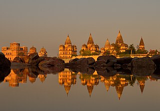
Orchha is a town, near the city of Niwari in the Niwari district of Madhya Pradesh state, India. The town was established by a Bundela rajput ruler Rudra Pratap Singh some time after 1501, as the seat of an eponymous former princely state of covering parts of central & north India, in the Bundelkhand region. Orchha lies on the Betwa River, 80 km from Tikamgarh and 15 km from Jhansi in Uttar Pradesh.

Tikamgarh is a town and a tehsil in Tikamgarh district in the Indian state of Madhya Pradesh. The city serves as a district headquarters. The earlier name of Tikamgarh was Tehri consisting of three hamlets, forming a rough triangle. In Tikamgarh town there is locality still known as 'Purani Tehri'. Until Indian independence in 1947, Tikamgarh, formerly called Tehri, was part of the kingdom of Orchha, which was founded in the 16th century by the Bundeli chief Rudra Pratap Singh, who became the first King of Orchha. In 1783 the capital of the state was moved to Tehri, about 40 miles (64 km) south of Orchha, which was home to the fort of Tikamgarh, and the town eventually took the name of the fort. The district is famous for the old fort of Kundar known as Garh Kundar, which was built by Khangars and remained the capital of Khangar rulers from 1180 to 1347.

Guna (Gwalior United National Army) is a city and a municipality in Guna district in the Indian state of Madhya Pradesh. It is the administrative headquarters of Guna District under Gwalior Division and is located on the banks of Parbati river.

Tikamgarh district is one of the 55 districts of Madhya Pradesh state in central India. Tikamgarh town is the district headquarters. The district is part of Sagar Division.

Shajapur is a town in Malwa region of Madhya Pradesh state in west-central India. It is the headquarters of Shajapur district.

Badagaon Dhasan is a town and a Nagar Parishad in Tikamgarh district in the state of Madhya Pradesh, India.
Bhander is a town and a nagar panchayat in Datia district in the state of Madhya Pradesh.
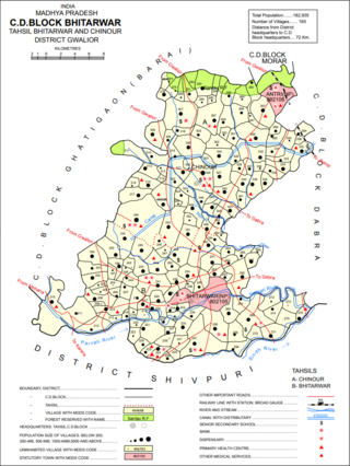
Bhitarwar is a city and a municipality in Gwalior district in the state of Madhya Pradesh, India. The town is surrounded by a river called Parbati.
Chourai is a town and a nagar panchayat in Chhindwara district in the state of Madhya Pradesh, India.
Jeron Khalsa is a town and a gram panchayat in Niwari district in the Indian state of Madhya Pradesh.
Karera is a municipality or Nagar Parishad in the Shivpuri district of the Indian state of Madhya Pradesh.
Khaniyadhana is a tehsil and a Nagar Palika in Shivpuri district in the Indian state of Madhya Pradesh. It is known for its eight Jain temples.
Lahar is a city and a Nagar Palika in Bhind district in the Indian state of Madhya Pradesh.
Makronia is a municipality in Sagar district in the Indian state of Madhya Pradesh. Its part of Sagar Urban Agglomeration.
Sarangpur is a city and tehsil in Rajgarh district in the Indian state of Madhya Pradesh. It is situated at the bank of the river Kali Sindh.
Pichhore is a town and a nagar panchayat in Shivpuri district in the Indian state of Madhya Pradesh. It's also a tehsil headquarter and Development block. it's loceted in Bundelkhand region of Madhya Pradesh.

Dabra is a town and municipality in Gwalior district in the state of Madhya Pradesh, India located near NH-44 national highway. It serves the headquarters for both a tehsil and a coterminous community development block.

Lavkushnagar, formerly known as Laundi and Lavpuri, is a town/tehshil and a nagar panchayat in Chhatarpur district in the Indian state of Madhya Pradesh. It is about 55 km (34 mi) away from Chhatarpur and 37 km (23 mi) from the temple town Khajuraho. The Urmil and Kail Rivers flow through this town. The Civil Airport Khajuraho and Dumra, Harpalpur, and Khajuraho Railway Station are located nearby, and links it to some major towns and cities of Madhya Pradesh. It also has a Civil Court, a Sub Jail, and a police station.
Teharka is a village in Niwari Tehsil in the Tikamgarh district of the Indian state of Madhya Pradesh. Teharka belongs to the Sagar Division. Teharka is the only village with two gram panchayats in Niwari Tehsil. It is located 78 km north of the district headquarters, Tikamgarh, and 320 km from the state capital, Bhopal. Teharka has borders with Prithvipur Tehsil in the south, Mauranipur Tehsil in the east, and Chirgaon Tehsil in the north.
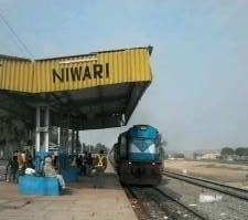
Niwari district is one of the 52 districts of the Madhya Pradesh state in India. Niwari is administrative headquarter of Niwari district.