
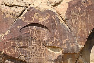
The Jeffers Petroglyphs site is an outcrop in southwestern Minnesota with pre-contact Native American petroglyphs. The petroglyphs are pecked into rock of the Red Rock Ridge, a 23-mile (37 km)-long Sioux quartzite outcrop that extends from Watonwan County, Minnesota to Brown County, Minnesota. The exposed surface is approximately 150 by 650 feet and surrounded by virgin prairie. Several old wagon trail ruts traverse the site, one of which is believed to be the old stage coach route from New Ulm, Minnesota to Sioux Falls, South Dakota.

This is a list of the National Register of Historic Places listings in Sanilac County, Michigan.
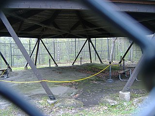
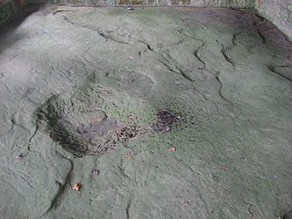
Sanilac Petroglyphs Historic State Park is a state park in Michigan containing Michigan's only known rock carvings attributable to Native American Indians. The park consists of 240 acres (97 ha) in Greenleaf Township, Sanilac County, in Michigan's Lower Peninsula. There is concern that without preservation, the carvings may be worn further away and lost. The site was added to the National Register of Historic Places in 1971.

Millstone Bluff is a natural bluff in Pope County, Illinois, United States, located near the community of Glendale. Listed on the National Register of Historic Places because of its archaeological significance, Millstone Bluff is one of three National Register sites in Pope County, along with the Golconda Historic District and part of the Kincaid Mounds State Historic Site.
The Leo Petroglyph is a sandstone petroglyph containing 37 images of humans and other animals as well as footprints of each. The petroglyph is located near the small village of Leo, Ohio and is thought to have been created by the Fort Ancient peoples. The area in which the sandstone petroglyph was found is on the edge of an unglaciated Mississippian sandstone cliff 20–65 feet high. To this day, the meanings of the drawings are unknown. On November 10, 1970, it was added to the National Register of Historic Places. The site is maintained by the Ohio History Connection.
Legend Rock Petroglyph Site is located in Hot Springs County, Wyoming, 20 miles northwest of Hot Springs State Park. Legend Rock is a petroglyph site which features hundreds of individual petroglyphs spread across the face of the rock. Although a handful of the rock's etchings have variously been eroded and defaced, a wide majority have been preserved for public viewing. The nearly 300 individual petroglyphs feature some of the oldest and best examples of Dinwoody rock art in the world. The origins of the petroglyphs are still subject to debate. The site was listed on the National Register of Historic Places on July 5, 1973. and it is preserved by the state of Wyoming as a state historic site.
This is a list of the National Register of Historic Places listings in Rice County, Kansas.

This is a list of the National Register of Historic Places listings in Washington County, Maine.

The Barnesville Petroglyph is a well-known petroglyph site in the eastern part of the U.S. state of Ohio. Located approximately 3 miles (4.8 km) southwest of the village of Barnesville in Belmont County, the petroglyphs have been known both by archaeologists and the general public since the 1850s or earlier. Although the site was significantly damaged during the twentieth century, it is still a significant archaeological site; as a result, it has been named a historic site.

This is a list of the National Register of Historic Places listings in Kingman County, Kansas.

Indian God Rock is a large boulder in the northwestern part of the U.S. state of Pennsylvania. Located near the unincorporated community of Brandon, it lies along the Allegheny River in Venango County's Rockland Township. It is significant for the large petroglyph on one of its sides. Because of the petroglyph, the rock has been an explorers' landmark, a tourist attraction, and an object of scholarly investigation.

The Francis Farm Petroglyphs are a group of petroglyphs in the southwestern part of the U.S. state of Pennsylvania. Located on a boulder in Jefferson Township in the northwestern portion of Fayette County, it has been known to archaeologists since at least the middle of the nineteenth century. Despite damage in the 1930s, it remains an important archaeological site, and accordingly, it has been designated a historic site.

The Sugar Grove Petroglyphs are a group of petroglyphs in the southwestern part of the U.S. state of Pennsylvania. Located on an outcrop of sandstone in Monongahela Township near the eastern edge of Greene County, the petroglyphs have been known since at least the 1930s. Due to their value as an archaeological site, the petroglyphs have been named a historic site.

Petroglyph Canyon (24CB601) is an archaeologically significant canyon in the northwestern United States. Located on both sides of the border between Montana and Wyoming, the canyon has long been obscure due to its small size. However, it gained substantial attention in the late 20th century because of its numerous prehistoric petroglyphs, and much of it was named a historic site in the 1970s.
Camp Beale Springs, near Kingman, Arizona, also known as Fort Beale, was a historic military facility that dates from 1857. It was listed on the National Register of Historic Places in 1974. Its location is not disclosed by the National Register, as is done for many archeological sites which have importance for their potential to yield information in the future.
The Yellow Jacket Petroglyphs, also known as CA-MNO-2189, are a 9.9-acre (4.0 ha) pre-Columbian archaeological site located in Mono County, California near Bishop, California. The site includes over 200 petroglyphs created by Paiute inhabitants of the region between 2950 B.C. and 1850 A.D. A wide array of design elements were used in the petroglyphs; the majority are abstract curved figures, but abstract lines, anthropomorphs, human and animal tracks, and cupules are also present. The site also includes remnants of human inhabitation, such as stacks of rocks thought to signify house sites, stone tools, ceramics, and animal remains.

The Lagomarsino Petroglyph Site (26ST1) is a 65-acre (26 ha) archeological site of petroglyphs, located in Storey County, Nevada near Virginia City. It was listed for its potential to yield information in the future, and includes one contributing site with approximately 2000 items.

The Bellows Falls Petroglyph Site is an archaeological site containing panels of precontact Native American petroglyphs in Bellows Falls, Vermont. Located near the Vilas Bridge on bedrock west of and above the Connecticut River, they depict a rarely-seen assemblage of anthropomorphic figures that is believed to be unique in New England, and uncommon even in surrounding geographic areas. The site was listed on the National Register of Historic Places in 1990.
The Torrey Lake Petroglyph District extends for about 3.2 miles (5.1 km) along Torrey Creek in Fremont County, Wyoming. The site includes about 175 petroglyphs, as well as eleven lithic scatters and a sheep trap. The petroglyphs are in the Interior Line Style, or Dinwoody style, consistent with other rock at in central Wyoming. Site investigations have uncovered a number of petroglyphs that had previously been hidden under lichen. The site was placed on the National Register of Historic Places on October 4, 1993.

