Oakland, Lawrence County, Pennsylvania

Last updated

Oakland, Pennsylvania
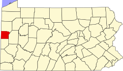
Map of Oakland, Lawrence County, Pennsylvania Highlighted.png
Location in Lawrence County
USA Pennsylvania location map.svg
Red pog.svg
Oakland
Location in Pennsylvania
Usa edcp location map.svg
Red pog.svg
Oakland
Location in the United States
Coordinates: 40°59′27″N80°21′46″W / 40.99083°N 80.36278°W / 40.99083; -80.36278
CountryUnited States
StatePennsylvania
County Lawrence
Township Union
Area
[1]
  Total0.93 sq mi (2.41 km2)
  Land0.92 sq mi (2.38 km2)
  Water0.01 sq mi (0.04 km2)
Elevation
1,105 ft (337 m)
Population
 (2020) [2]
  Total1,437
  Density1,565.36/sq mi (604.66/km2)
Time zone UTC-4 (EST)
  Summer (DST) UTC-5 (EDT)
Area code 724
FIPS code 42-56000
GNIS feature ID2389605

Oakland is an unincorporated area and census-designated place (CDP) in Lawrence County, Pennsylvania, United States. The population was 1,569 at the 2010 census. [3]

Contents

Geography

Oakland is located in central Lawrence County at 40°59′27″N80°21′46″W / 40.99083°N 80.36278°W / 40.99083; -80.36278 (40.990795, -80.362675). [4] It sits in the southeastern corner of Union Township, bordered to the south and east by the city of New Castle, the Lawrence county seat, and to the north by Oakwood.

According to the United States Census Bureau, the CDP has a total area of 0.93 square miles (2.4 km2), of which 0.02 square miles (0.04 km2), or 1.55%, are water. [5] The community sits on a hill overlooking the Shenango River to the east. The Shenango is a southward-flowing tributary of the Beaver River and is part of the Ohio River watershed.

Demographics

Historical population
CensusPop.Note
2020 1,437
U.S. Decennial Census [6]

As of the census [7] of 2000, there were 1,516 people, 617 households, and 434 families residing in the CDP. The population density was 1,653.3 inhabitants per square mile (638.3/km2). There were 656 housing units at an average density of 715.4 per square mile (276.2/km2). The racial makeup of the CDP was 92.22% White, 6.79% African American, 0.20% Asian, 0.40% from other races, and 0.40% from two or more races. Hispanic or Latino of any race were 0.33% of the population.

There were 617 households, out of which 27.7% had children under the age of 18 living with them, 53.3% were married couples living together, 12.0% had a female householder with no husband present, and 29.5% were non-families. 26.6% of all households were made up of individuals, and 16.7% had someone living alone who was 65 years of age or older. The average household size was 2.46 and the average family size was 2.97.

In the CDP, the population was spread out, with 21.5% under the age of 18, 7.5% from 18 to 24, 26.2% from 25 to 44, 22.9% from 45 to 64, and 21.9% who were 65 years of age or older. The median age was 42 years. For every 100 females, there were 93.4 males. For every 100 females age 18 and over, there were 92.6 males.

The median income for a household in the CDP was $37,885, and the median income for a family was $40,450. Males had a median income of $36,500 versus $19,674 for females. The per capita income for the CDP was $15,015. About 5.5% of families and 7.6% of the population were below the poverty line, including 7.8% of those under age 18 and 7.9% of those age 65 or over.

Related Research Articles

<span class="mw-page-title-main">Brickerville, Pennsylvania</span> Census-designated place in Pennsylvania, United States

Brickerville is an unincorporated community and census-designated place (CDP) in Elizabeth Township, Lancaster County, Pennsylvania, United States, with a ZIP code of 17543. The population was 1,309 at the 2010 census.

<span class="mw-page-title-main">Belmont, Pennsylvania</span> Census-designated place in Pennsylvania, United States

Belmont is an unincorporated community and census-designated place (CDP) in Cambria County, Pennsylvania, United States. The population was 2,784 at the 2010 census.

<span class="mw-page-title-main">Hyde, Pennsylvania</span> Census-designated place in Pennsylvania, United States

Hyde is an unincorporated community and census-designated place (CDP) in Clearfield County, Pennsylvania, United States. The population was 1,303 at the 2020 census.

<span class="mw-page-title-main">Geneva, Pennsylvania</span> Census-designated place in Pennsylvania, United States

Geneva is a census-designated place in Crawford County, Pennsylvania, United States. The population was 109 at the 2010 census.

<span class="mw-page-title-main">North Shenango Township, Crawford County, Pennsylvania</span> Township in Pennsylvania, United States

North Shenango Township is a township in Crawford County, Pennsylvania, United States. The population was 1,278 at the 2020 census, down from 1,410 at the 2010 census.

<span class="mw-page-title-main">Pymatuning Central, Pennsylvania</span> Census-designated place in Pennsylvania, United States

Pymatuning Central is a census-designated place (CDP) in Crawford County, Pennsylvania, United States. The population was 2,269 at the 2010 census.

<span class="mw-page-title-main">Pymatuning South, Pennsylvania</span> Census-designated place in Pennsylvania, United States

Pymatuning South is a census-designated place (CDP) in Crawford County, Pennsylvania, United States. The population was 479 at the 2010 census.

<span class="mw-page-title-main">South Shenango Township, Crawford County, Pennsylvania</span> Township in Pennsylvania, United States

South Shenango Township is a township in Crawford County, Pennsylvania, United States. The population was 1,836 at the 2020 census, down from 2,037 at the 2010 census.

<span class="mw-page-title-main">West Fallowfield Township, Crawford County, Pennsylvania</span> Township in Pennsylvania, United States

West Fallowfield Township is a township in Crawford County, Pennsylvania, United States. The population was 578 at the 2020 census, down from 605 at the 2010 census.

<span class="mw-page-title-main">West Shenango Township, Crawford County, Pennsylvania</span> Township in Pennsylvania, United States

West Shenango Township is a township in Crawford County, Pennsylvania, United States. The population was 436 at the 2020 census, down from 504 at the 2010 census.

<span class="mw-page-title-main">New Castle Northwest, Pennsylvania</span> Census-designated place in Pennsylvania, United States

New Castle Northwest is an unincorporated area and census-designated place (CDP) in Lawrence County, Pennsylvania, United States. The population was 1,413 at the 2010 census.

<span class="mw-page-title-main">Oakwood, Pennsylvania</span> Census-designated place in Pennsylvania, United States

Oakwood is an unincorporated area and census-designated place (CDP) in Lawrence County, Pennsylvania, United States. The population was 2,270 at the 2010 census.

<span class="mw-page-title-main">Shenango Township, Lawrence County, Pennsylvania</span> Township in Pennsylvania, United States

Shenango Township is a township in Lawrence County, Pennsylvania, United States. The population was 7,133 at the 2020 census, a decline from the figure of 7,479 tabulated in 2010. Shenango Township is situated between the city of New Castle to the north and the borough of Ellwood City to the south.

<span class="mw-page-title-main">Union Township, Lawrence County, Pennsylvania</span> Township in Pennsylvania, United States

Union Township is a township in Lawrence County, Pennsylvania, United States. The population was 4,997 at the time of the 2020 census, a decline from the figure of 5,190 as of 2010.

<span class="mw-page-title-main">Trevorton, Pennsylvania</span> CDP in Pennsylvania, United States

Trevorton is a census-designated place (CDP) in Zerbe Township, Northumberland County, Pennsylvania, United States. The population was 1,834 at the 2010 census.

<span class="mw-page-title-main">Gastonville, Pennsylvania</span> Census-designated place in Pennsylvania, United States

Gastonville is a census-designated place (CDP) in Washington County, Pennsylvania, United States. The population was 2,818 at the 2010 census.

<span class="mw-page-title-main">McMurray, Pennsylvania</span> Census-designated place in Pennsylvania, United States

McMurray is a census-designated place (CDP) in Peters Township, Washington County, Pennsylvania. The population was 4,736 at the 2020 census. It is part of the Pittsburgh metropolitan area. Its zip code is 15317, which it shares with neighboring borough Canonsburg.

<span class="mw-page-title-main">Thompsonville, Pennsylvania</span> Census-designated place in Pennsylvania, United States

Thompsonville is a census-designated place (CDP) in Washington County, Pennsylvania, United States. The population was 3,520 at the 2010 census.

Lawson Heights is a census-designated place (CDP) in Unity Township, Westmoreland County, Pennsylvania, United States. The population was 2,339 at the 2000 census.

Norfolk is a hamlet in St. Lawrence County, New York, United States. The population was 1,327 at the 2010 census.

References

  1. "ArcGIS REST Services Directory". United States Census Bureau. Retrieved October 12, 2022.
  2. "Census Population API". United States Census Bureau. Retrieved October 12, 2022.
  3. "Total Population: 2010 Census DEC Summary File 1 (P1), Oakland CDP (Lawrence County), Pennsylvania". data.census.gov. U.S. Census Bureau. Retrieved October 8, 2020.
  4. "US Gazetteer files: 2010, 2000, and 1990". United States Census Bureau. February 12, 2011. Retrieved April 23, 2011.
  5. "2019 U.S. Gazetteer Files: Places: Pennsylvania". United States Census Bureau. Retrieved October 8, 2020.
  6. "Census of Population and Housing". Census.gov. Retrieved June 4, 2016.
  7. "U.S. Census website". United States Census Bureau . Retrieved January 31, 2008.