Rose Point, Pennsylvania

Last updated

Rose Point, Pennsylvania
The Point in Rose Point.jpg
The actual Rose Point at the center of the community
PAMap-doton-Rose Point.png
Location of Rose Point, Pennsylvania
Map of Rose Point in Slippery Rock Township, 1872.png
Map of Rose Point in 1872
Coordinates: 40°58′12″N80°11′11″W / 40.97000°N 80.18639°W / 40.97000; -80.18639
Country United States
State Pennsylvania
County Lawrence
Township Slippery Rock
Elevation
1,106 ft (337 m)
Time zone UTC-5 (Eastern (EST))
  Summer (DST) UTC-4 (EDT)
GNIS feature ID1185451 [1]

Rose Point is an unincorporated community in east central Slippery Rock Township, Lawrence County, Pennsylvania, United States, very close to the Butler County line. Founded approximately 200 years ago, the community lies in a rural yet formerly industrial region of fields and broken terrain.

Contents

Geography

Rose Point's elevation is 1,106 feet (337 m). [1] It lies on the northern side of U.S. Route 422 at its intersection with Rose Point Road, along the gorge of the Slippery Rock Creek. [2] Located east of the city of New Castle, the county seat of Lawrence County, [3] the community sits approximately midway between New Castle and Butler. It lies near two of U.S. 422's significant intersections: with U.S. Route 19, approximately 1 mile (1.6 km) away, and with Interstate 79, about 3 miles (4.8 km) distant. In the vicinity of Rose Point are multiple state parks: Moraine State Park, including the large Lake Arthur, is located to the east not far past Interstate 79, while McConnells Mill State Park sits on the opposite side of U.S. 422. [4]

Geology

The bedrock around Rose Point is primarily the soft rock of the large Vanport Limestone layer, which has a 93.6% content of calcium carbonate and low levels of magnesium carbonate and silica. [5] Hydrocarbons were originally prevalent in the township: significant coal beds of fine quality were found throughout the area, and oil wells were drilled in hopes of reaching the edge of the Venango County-centered oil fields. Seen most clearly in the deep and broken gorge of the Slippery Rock Creek [6] is the karst topography of the region around Rose Point, which also includes significant cave complexes. Leading among the caves in the area is the Harlansburg Cave, Pennsylvania's longest cave, which has been reported to extend from Harlansburg (eleven miles away) to Rose Point. [5] Smaller caves such as the Rose Point Cave also exist in the area, parallel to the Harlansburg Cave; all these caves are believed to have been formed by stream water forced underground during wetter times of the year, causing their passages to be maze-like rather than linear. [5]

History

Rose Point Reformed Presbyterian Church Rose Point Reformed Presbyterian Church.jpg
Rose Point Reformed Presbyterian Church

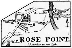
The first settler in the Rose Point vicinity were Abraham Wigle and Samuel Stickle of Westmoreland County, who arrived in 1804. Wigle was the first of many to harness the power of the Slippery Rock Creek, building a gristmill and a sawmill on its banks in about 1825; although Wigle's mill was destroyed by water, another mill (later abandoned) was built shortly before 1850, [6] and the still-preserved McConnells Mill is just 2 miles (3.2 km) downstream. [2] Various businesses were established in the community, including a hotel, blacksmiths' and cobblers' shops, and multiple stores. Two churches were established in the community: one Reformed Presbyterian (which still exists), and one Roman Catholic. Slippery Rock Township's natural resources were exploited in Rose Point, with iron furnaces being built to use locally produced iron ore, coal, and limestone. [6] Of these two, the Willie Roy or Wilroy Furnace, built in 1854, has been recognized as a Pennsylvania state historic location. [6] [7] Public services were also introduced to the community: a post office was opened in the 1850s, and a village school was established in the early 1860s. Dates given for the establishment of the Rose Point post office vary from 1852 to 1858; regardless of the date of its establishment, the post office operated until disestablishment in 1933. [8] Today, Rose Point addresses are served by the New Castle ZIP code, 16101. [9] While the community has long been known only as Rose Point, it also bore the name of "Stonetown" for a time in its early history; the post office, however, was always named Rose Point. [6]

Related Research Articles

<span class="mw-page-title-main">Butler County, Pennsylvania</span> County in Pennsylvania, United States

Butler County is a county in the Commonwealth of Pennsylvania. It is part of Western Pennsylvania. As of the 2020 census, the population was 193,763. Its county seat is Butler. Butler County was created on March 12, 1800, from part of Allegheny County and named in honor of General Richard Butler, a hero of the American Revolution.

<span class="mw-page-title-main">Exeter Township, Berks County, Pennsylvania</span> Township in Pennsylvania, United States

Exeter Township is a township in Berks County, Pennsylvania, United States. The population was 25,500 as of the 2020 census, making it the third-most populous municipality in Berks County after the city of Reading and Spring Township. Daniel Boone Homestead is within its borders. This formerly rural township is now made up of mostly sprawl-oriented developments along U.S. Route 422 and Route 562 Its school district also contains the adjacent borough of St. Lawrence.

<span class="mw-page-title-main">Muddy Creek Township, Pennsylvania</span> Township in Pennsylvania, United States

Muddy Creek Township is a township in Butler County, Pennsylvania, United States. The population was 2,210 at the 2020 census.

<span class="mw-page-title-main">Portersville, Pennsylvania</span> Village in Pennsylvania, United States

Portersville is a borough in Butler County, Pennsylvania, United States. The population was 235 at the 2010 census.

<span class="mw-page-title-main">Slippery Rock Township, Butler County, Pennsylvania</span> Township in Pennsylvania, United States

Slippery Rock Township is a township in Butler County, Pennsylvania, United States. The population was 6,719 at the 2020 census.

<span class="mw-page-title-main">New Castle, Pennsylvania</span> City in Pennsylvania, United States

New Castle is a city in and the county seat of Lawrence County, Pennsylvania, United States. Located along the Shenango River at the mouth of Neshannock Creek, it is 43 miles (69 km) northwest of Pittsburgh near the Pennsylvania–Ohio border, approximately 17 miles (27 km) southeast of Youngstown, Ohio. As of the 2020 census, the city had a population of 21,926. The commercial center of a fertile agricultural region, New Castle is included in the northwestern part of the Pittsburgh metropolitan area.

<span class="mw-page-title-main">Perry Township, Lawrence County, Pennsylvania</span> Township in Pennsylvania, United States

Perry Township is a township in Lawrence County, Pennsylvania, United States. The population was 1,854 at the time of the 2020 census, a decline from the figure of 1,938 tabulated in 2010.

<span class="mw-page-title-main">Shenango Township, Lawrence County, Pennsylvania</span> Township in Pennsylvania, United States

Shenango Township is a township in Lawrence County, Pennsylvania, United States. The population was 7,133 at the 2020 census, a decline from the figure of 7,479 tabulated in 2010. Shenango Township is situated between the city of New Castle to the north and the borough of Ellwood City to the south.

<span class="mw-page-title-main">Slippery Rock Township, Lawrence County, Pennsylvania</span> Township in Pennsylvania, United States

Slippery Rock Township is a township in Lawrence County, Pennsylvania, United States. As of the 2020 census, the population was 2,913, a decline from the figure of 3,283 tabulated in 2010.

<span class="mw-page-title-main">McConnells Mill State Park</span> State park in Pennsylvania, United States

McConnells Mill State Park is a 2,546 acres (1,030 ha) Pennsylvania state park in Perry and Slippery Rock Townships, Lawrence County, Pennsylvania in the United States. The park features a deep scenic gorge with the restored watermill and a covered bridge at the bottom, accessible by a roadway that winds between large, room-sized boulders on the hillside. McConnells Mill State Park is along the Slippery Rock Creek. just southwest of the intersection of US 422 and US 19.

<span class="mw-page-title-main">U.S. Route 422</span> Highway in Ohio and Pennsylvania

U.S. Route 422 (US 422) is a 271-mile-long (436 km) spur route of US 22 split into two segments in the U.S. states of Ohio and Pennsylvania. The western segment of US 422 runs from downtown Cleveland, Ohio, east to Ebensburg, Pennsylvania. The eastern segment, located entirely within Pennsylvania, runs from Hershey east to King of Prussia, near Philadelphia. US 422 Business serves as a business route into each of four towns along the way.

<span class="mw-page-title-main">Harlansburg, Pennsylvania</span> Unincorporated community in Pennsylvania, United States

Harlansburg is a community 8 miles (13 km) east of the city of New Castle in Lawrence County, Pennsylvania, United States.

<span class="mw-page-title-main">Pennsylvania Route 108</span> State highway in Pennsylvania, US

Pennsylvania Route 108 is a highway in Western Pennsylvania that runs for 32 miles (51 km) from the Ohio state line near SNPJ to PA 8 in Adams Corner. PA 108 intersects Interstate 376 (I-376) near New Castle and U.S. Route 19 (US 19) near Harlansburg. PA 108 also has an interchange with Interstate 79 (I-79) at exit 105.

<span class="mw-page-title-main">Pennsylvania Route 388</span> State highway in Lawrence County, Pennsylvania, US

Pennsylvania Route 388 is a north–south state highway in Lawrence County, Pennsylvania, United States, located in Western Pennsylvania. It travels 8.4 miles (13.5 km) between PA 168 in East Brook and PA 65 in Energy.

<span class="mw-page-title-main">Pennsylvania Route 345</span> State highway in Pennsylvania, US

Pennsylvania Route 345 is a 13-mile-long (21 km) state highway in the U.S. state of Pennsylvania. The route runs from PA 82 in West Nantmeal Township, Chester County, north to U.S. Route 422 near Birdsboro, Berks County. The route is a two-lane road its entire length, passing through the community of Warwick, Hopewell Furnace National Historic Site, French Creek State Park, and the borough of Birdsboro. PA 345 intersects PA 401 in East Nantmeal Township, PA 23 in Warwick, and PA 724 in Birdsboro. PA 345 was first designated by 1973 between PA 82 in West Nantmeal Township and PA 724 in Birdsboro. The route was extended north to US 422 in 2008, replacing a former section of PA 82 north of Birdsboro that was initially designated in 1928.

<span class="mw-page-title-main">Pennsylvania Route 488</span> State highway in Pennsylvania, US

Pennsylvania Route 488 is a 17-mile-long (27 km) state highway located in Lawrence and Butler counties in Pennsylvania. The western terminus is at PA 65/PA 288 in Ellwood City. The eastern terminus is at U.S. Route 422 in Moraine State Park.

<span class="mw-page-title-main">New Castle Area Transit Authority</span>

New Castle Area Transit Authority is a public transportation service located in Lawrence County, Pennsylvania. It provides inter-city bus and paratransit service to select communities within the county. Because the region is located within the metropolitan area of Pittsburgh, service is provided to the downtown area.

<span class="mw-page-title-main">McConnell's Mill Covered Bridge</span> United States historic place

The McConnell's Mill Covered Bridge is an historic, wooden covered bridge that is located in Slippery Rock Township, Lawrence County, Pennsylvania, United States. It spans the Slippery Rock Creek in McConnells Mill State Park, southeast of Rose Point.

<span class="mw-page-title-main">Lawrence County, Pennsylvania</span> County in Pennsylvania, United States

Lawrence County is a county in the Commonwealth of Pennsylvania. As of the 2020 census, the population was 86,070. The county seat and largest city is New Castle.

Jamison Run is a small tributary of Slippery Rock Creek in western Pennsylvania. The stream rises in northern Lawrence County and flows south entering Slippery Rock Creek at Elliotts Mills, Pennsylvania. The watershed is roughly 46% agricultural, 45% forested and the rest is other uses.

References

  1. 1 2 "Rose Point, Pennsylvania". Geographic Names Information System . United States Geological Survey, United States Department of the Interior.
  2. 1 2 General Highway Map, Lawrence County, Pennsylvania Archived 2011-08-05 at Wikiwix, Pennsylvania Department of Transportation, 2008. Accessed 2008-12-12.
  3. "Find a County". National Association of Counties. Retrieved June 7, 2011.
  4. DeLorme. Pennsylvania Atlas & Gazetteer. 9th ed. Yarmouth: DeLorme, 2006, p. 56-57. ISBN   0-89933-280-3.
  5. 1 2 3 Fawley, J. Philip and Kenneth M. Long. "Harlansburg Cave: The Longest Cave in Pennsylvania" [ dead link ], Journal of Cave and Karst Studies 59, p. 106-111.
  6. 1 2 3 4 5 Durant, S.W. and P.A. Durant. History of Lawrence County Pennsylvania, 1770-1877, Slippery Rock Township, transcribed and posted on 2001-03-21. Accessed 2008-12-12.
  7. Wilroy Furnace, OurHistoricPlaces, 2008. Accessed 2008-12-12.
  8. Pennsylvania — Lawrence County, PostalHistory.com. Accessed 2008-12-14.
  9. Directions, Rose Point Reformed Presbyterian Church; and Directions to Rose Point Park, Rose Point Park. Both undated; both accessed 2008-12-13.