
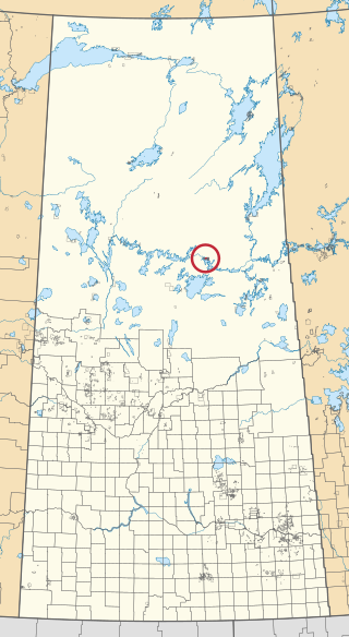
Gordon 86 is a Cree reserve in Saskatchewan, Canada located 61 kilometres (38 mi) northwest of Fort Qu'Appelle. Also known as the George Gordon Reserve, it is one of three territories of the George Gordon First Nation, as arranged by the signing of Treaty 4. The reserve has an area of 14,438.3 hectares. In the 2016 Canadian Census, it recorded a population of 837 living in 218 of its 238 total private dwellings. In the same year, its Community Well-Being index was calculated at 52 of 100, compared to 58.4 for the average First Nations community and 77.5 for the average non-Indigenous community. It is almost completely surrounded by the rural municipality of Touchwood No. 248.

Division No. 6 is one of eighteen census divisions in the province of Saskatchewan, Canada, as defined by Statistics Canada. It is located in the south-central part of the province. The most populous community in this division is Regina, the provincial capital.
The Lac La Ronge Indian Band is a Woodland Cree First Nation in northern Saskatchewan, it is the largest Cree band government in Canada and the largest First Nation in Saskatchewan. The administrative centre of the Lac La Ronge Indian Band is located in La Ronge.
Minton is a village in the Canadian province of Saskatchewan within the Rural Municipality of Surprise Valley No. 9 and Census Division No. 2. It is on Highway 6 just north of its intersection with Highway 18, 19 km north of the Raymond-Regway Border Crossing on the Montana-Saskatchewan border. The village was named after Minton, Shropshire in England. The name was given by the Canadian Pacific Railway.
Grandmother's Bay 219 is an Indian reserve of the Lac La Ronge Indian Band in Saskatchewan. Located on Otter Lake, part of the Churchill River system, it is 77 kilometers northeast of Lac la Ronge. In the 2016 Canadian Census, it recorded a population of 342 living in 101 of its 115 total private dwellings. In the same year, its Community Well-Being index was calculated at 44 of 100, compared to 58.4 for the average First Nations community and 77.5 for the average non-Indigenous community.

Fort Vermilion 173B is an Indian reserve of the Tallcree First Nation in Alberta, located within Mackenzie County. It is 1 kilometre southwest of Fort Vermilion. In the 2016 Canadian Census, it recorded a population of 96 living in 23 of its 25 total private dwellings.

Janvier 194 is an Indian reserve of the Chipewyan Prairie First Nation in Alberta, Canada that is surrounded by the Regional Municipality of Wood Buffalo. It is 97 km (60 mi) southwest of Fort McMurray.

Old Fort 217 is an Indian reserve of the Mikisew Cree First Nation in Alberta, located within Regional Municipality of Wood Buffalo. In the 2016 Canadian Census, it recorded a population of 0 living in 0 private dwellings. It is located 188 kilometres (117 mi) north of Fort McMurray, at an elevation of 214 metres (702 ft). In 2001, there were 5 people living on-reserve.

Namur Lake 174B is an Indian reserve of the Fort McKay First Nation in Alberta, located within the Regional Municipality of Wood Buffalo. It is 105 kilometres northwest of Fort McMurray.

Day Star 87 is an Indian reserve of the Day Star First Nation in Saskatchewan. It is 87 kilometres northwest of Fort Qu'Appelle. In the 2016 Canadian Census, it recorded a population of 148 living in 42 of its 62 total private dwellings. In the same year, its Community Well-Being index was calculated at 65 of 100, compared to 58.4 for the average First Nations community and 77.5 for the average non-Indigenous community.

Four Portages 157C is an Indian reserve of the Lac La Ronge Indian Band in Saskatchewan. It is 23 miles (37 km) north-east of La Ronge, and on the north shore of Lac la Ronge.

Fox Point 157D is an Indian reserve of the Lac La Ronge Indian Band in Saskatchewan. It is 16 miles south-east of La Ronge, and on the south-west shore of Lac la Ronge.

Fox Point 157E is an Indian reserve of the Lac La Ronge Indian Band in Saskatchewan. It is 18 miles south-east of La Ronge, and on an island near the south shore of Lac la Ronge.

Muscowpetung 80 is an Indian reserve of the Muscowpetung First Nation in Saskatchewan. It is 31 kilometres west of Fort Qu'Appelle along the south-west shore of Pasqua Lake, which is one of four Fishing Lakes. In the 2016 Canadian Census, it recorded a population of 275 living in 87 of its 112 total private dwellings. In the same year, its Community Well-Being index was calculated at 54 of 100, compared to 58.4 for the average First Nations community and 77.5 for the average non-Indigenous community.

Muskowekwan 85 is an Indian reserve of the Muskowekwan First Nation in Saskatchewan. It is 64 kilometres northwest of Fort Qu'Appelle. In the 2016 Canadian Census, it recorded a population of 436 living in 150 of its 170 total private dwellings. In the same year, its Community Well-Being index was calculated at 52 of 100, compared to 58.4 for the average First Nations community and 77.5 for the average non-Indigenous community.

Pasqua 79 is an Indian reserve of the Pasqua First Nation in Saskatchewan. It is 16 kilometres west of Fort Qu'Appelle. In the 2016 Canadian Census, it recorded a population of 517 living in 173 of its 200 total private dwellings. In the same year, its Community Well-Being index was calculated at 56 of 100, compared to 58.4 for the average First Nations community and 77.5 for the average non-Indigenous community.
Piapot 75 is an Indian reserve of the Piapot Cree Nation in Saskatchewan. It is 43 kilometres west of Fort Qu'Appelle. In the 2016 Canadian Census, it recorded a population of 516 living in 143 of its 171 total private dwellings. In the same year, its Community Well-Being index was calculated at 55 of 100, compared to 58.4 for the average First Nations community and 77.5 for the average non-Indigenous community.

Poorman 88 is an Indian reserve of the Kawacatoose First Nation in Saskatchewan. It is 87 kilometres northwest of Fort Qu'Appelle. In the 2016 Canadian Census, it recorded a population of 729 living in 172 of its 196 total private dwellings. In the same year, its Community Well-Being index was calculated at 47 of 100, compared to 58.4 for the average First Nations community and 77.5 for the average non-Indigenous community.

Stanley 157 is an Indian reserve of the Lac La Ronge Indian Band in Saskatchewan. It is 56 kilometres northeast of Lac la Ronge. In the 2016 Canadian Census, it recorded a population of 1840 living in 451 of its 466 total private dwellings. In the same year, its Community Well-Being index was calculated at 52 of 100, compared to 58.4 for the average First Nations community and 77.5 for the average non-Indigenous community.

Stanley 157A is an Indian reserve of the Lac La Ronge Indian Band in Saskatchewan, Canada. It is 41 miles north-east of La Ronge, and 7 miles east of Stanley on the south shore of the Churchill River.
