Old Pino, California

Last updated

Coordinates: 38°49′05″N120°38′50″W / 38.81806°N 120.64722°W / 38.81806; -120.64722

Geographic coordinate system Coordinate system

A geographic coordinate system is a coordinate system that enables every location on Earth to be specified by a set of numbers, letters or symbols. The coordinates are often chosen such that one of the numbers represents a vertical position and two or three of the numbers represent a horizontal position; alternatively, a geographic position may be expressed in a combined three-dimensional Cartesian vector. A common choice of coordinates is latitude, longitude and elevation. To specify a location on a plane requires a map projection.

Old Pino
Unincorporated community
California Locator Map with US.PNG
Red pog.svg
Old Pino
Location in California
Usa edcp location map.svg
Red pog.svg
Old Pino
Old Pino (the US)
Coordinates: 38°49′05″N120°38′50″W / 38.81806°N 120.64722°W / 38.81806; -120.64722
Country United States
State California
County El Dorado County
Elevation [1] 3,156 ft (962 m)

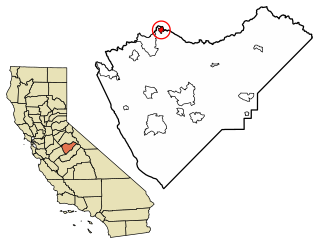
Old Pino is an unincorporated community in El Dorado County, California. [1] It is located 5 miles (8 km) northwest of Pollock Pines, [2] at an elevation of 3156 feet (962 m). [1]

Unincorporated area Region of land not governed by own local government

In law, an unincorporated area is a region of land that is not governed by a local municipal corporation; similarly an unincorporated community is a settlement that is not governed by its own local municipal corporation, but rather is administered as part of larger administrative divisions, such as a township, parish, borough, county, city, canton, state, province or country. Occasionally, municipalities dissolve or disincorporate, which may happen if they become fiscally insolvent, and services become the responsibility of a higher administration. Widespread unincorporated communities and areas are a distinguishing feature of the United States and Canada. In most other countries of the world, there are either no unincorporated areas at all, or these are very rare; typically remote, outlying, sparsely populated or uninhabited areas.

El Dorado County, California County in California

El Dorado County, officially the County of El Dorado, is a county in the U.S. state of California. As of the 2010 census, the population was 181,058. The county seat is Placerville.

California State of the United States of America

California is a state in the Pacific Region of the United States. With 39.6 million residents, California is the most populous U.S. state and the third-largest by area. The state capital is Sacramento. The Greater Los Angeles Area and the San Francisco Bay Area are the nation's second- and fifth-most populous urban regions, with 18.7 million and 9.7 million residents respectively. Los Angeles is California's most populous city, and the country's second-most populous, after New York City. California also has the nation's most populous county, Los Angeles County, and its largest county by area, San Bernardino County. The City and County of San Francisco is both the country's second-most densely populated major city after New York City and the fifth-most densely populated county, behind only four of the five New York City boroughs.

Related Research Articles

Norbourne Estates, Kentucky City in Kentucky, United States

Norbourne Estates is a home rule-class city in Jefferson County, Kentucky, United States. The population was 441 at the 2010 census.

Steedman, Missouri unincorporated community in Missouri

Steedman is an unincorporated community in southeastern Callaway County in the U.S. state of Missouri. The community is located on Missouri Route CC and Missouri Route 94 between Portland to the east and Mokane to the west above the Missouri River floodplain.

Glencoe, California Unincorporated community in California, United States

Glencoe is an unincorporated community in Calaveras County, California. It lies at an elevation of 2749 feet and is located at 38°21′15″N120°35′06″W. The community is in ZIP code 95232 and area code 209.

Buck Meadows, California Census designated place in California, United States

Buck Meadows is a census-designated place in Mariposa County, California. It is located 2 miles (3.2 km) east-northeast of Smith Peak, at an elevation of 3015 feet. The population was 31 at the 2010 census.

CHNL is a radio station in Kamloops, British Columbia, Canada. The station, owned by Newcap Radio since 2017, airs a classic hits format with some talk and sports at 610 on the AM dial. The station launched in 1970.

Saint Marks, Indiana Unincorporated community in Indiana, United States

Saint Marks is an unincorporated community in Jackson Township, Dubois County, in the U.S. state of Indiana.

Phillips, California Unincorporated community in California, United States

Phillips is a small unincorporated community in El Dorado County, California. It is located on the South Fork of the American River, 2.5 miles (4 km) west of Echo Summit, at an elevation of 6,873 feet. It is the site of the Sierra-at-Tahoe ski resort. The ZIP code is 95720. The community is inside area code 530.

Tyndall Landing, California Unincorporated community in California, United States

Tyndall Landing is an unincorporated community in Yolo County, California. It is located on the Sacramento River 8 miles (13 km) east of Dunnigan, at an elevation of 36 feet.

Cedar Vista, California Unincorporated community in California, United States

Cedar Vista is an unincorporated community in Calaveras County, California. It lies at an elevation of 3317 feet. Cedar Vista is located at 38°10′10″N120°24′29″W.

Old Fort Jim, California Unincorporated community in California, United States

Old Fort Jim is an unincorporated community in El Dorado County, California. It is located 3 miles (4.8 km) southwest of Camino, at an elevation of 2247 feet.

Pino Grande, California Unincorporated community in California, United States

Pino Grande is an unincorporated community in El Dorado County, California. It is located 8 miles (13 km) north-northwest of Pollock Pines, at an elevation of 4022 feet.

Springfield Meadows, California Unincorporated community in California, United States

Springfield Meadows is an unincorporated community in El Dorado County, California. It lies at an elevation of 577 feet.

Pueblo de las Juntas is a former settlement in Fresno County, California situated at the confluence of the San Joaquin River and Fresno Slough, 2 miles (3.2 km) north of Mendota.

Ridgewood, New York is a hamlet in the town of Newfane in Niagara County, New York, United States.

Rancho Cañada de los Pinos or College Rancho was a 35,499-acre (143.66 km2) Mexican land grant in present-day Santa Barbara County, California. The grant extended along the north bank of the Santa Ynez River opposite Rancho Lomas de la Purificacion and encompassed Mission Santa Inés and present-day Santa Ynez, in the Santa Ynez Valley.

Solun Glacier

Solun Glacier is the 9.3 km long and 4 km wide glacier on Pernik Peninsula, Loubet Coast on the west side of Antarctic Peninsula, situated east of Škorpil Glacier and northwest of McCance Glacier. It drains the north slopes of Protector Heights, and flows northwards into Darbel Bay.

Fletcher Mill is an unincorporated community in Rappahannock County, in the U.S. state of Virginia.

Birds Run is an unincorporated community in Guernsey County, in the U.S. state of Ohio.

Wick is an unincorporated community in Ashtabula County, in the U.S. state of Ohio.

Elm Point is an unincorporated community in St. Charles County, in the U.S. state of Missouri.

References

  1. 1 2 3 U.S. Geological Survey Geographic Names Information System: Old Pino, California
  2. Durham, David L. (1998). California's Geographic Names: A Gazetteer of Historic and Modern Names of the State. Clovis, Calif.: Word Dancer Press. ISBN   1-884995-14-4.