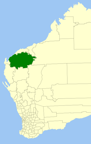
The Shire of Ashburton is one of the four local government areas in the Pilbara region of Western Australia, covering an area of 105,647 square kilometres (40,791 sq mi). It is named after the Ashburton River.

Jandakot Airport is a general aviation (GA) airport located in Jandakot, Western Australia, about 20 kilometres (12 mi) south-southwest of the "general aviation area of the Airport West precinct" at Perth Airport. Jandakot airport opened in 1963. From 1 July 1998, Jandakot Airport Holdings purchased a 50-year lease with a 49-year option to operate and maintain the airport including its conservation areas.

Busselton Margaret River Airport, formerly known as Busselton Regional Airport and alternatively known as Busselton-Margaret River Regional Airport, is located in the Busselton suburb of Yalyalup, 6.5 km (4.0 mi) from the Busselton town centre. Busselton is a major regional centre in the South West of Western Australia, about 220 km (140 mi) south of Perth and at the edge of the Margaret River wine region.

Albany Airport, also known as Harry Riggs Albany Regional Airport, is an airport serving Albany, Western Australia. It is located 6 nautical miles northwest of Albany just off Albany Highway and operated by the City of Albany. It is the largest airport in the Great Southern region.

Newman Airport is an airport near Newman, in the Pilbara region of Western Australia, situated 5.5 nautical miles southeast of the town.

Camden Airport is an aerodrome located on the outskirts of Sydney, 1 nautical mile northwest of Camden, New South Wales, Australia. The airport is located approximately 60 km (37 mi) from Sydney's central business district. Camden is used as a general aviation overflow airport for the busier Bankstown Airport, and provides facilities for gliding and ballooning. The aerodrome has one grass runway and one paved runway and two glider airstrips. It is in the south-west corner of the designated Sydney flight training area.

Geraldton Airport is an airport located 6 nautical miles east of Geraldton, Western Australia, in Moonyoonooka along the Geraldton – Mount Magnet Road.
Kalbarri Airport in Kalbarri, Western Australia is owned and operated by the Shire of Northampton. The airport is approximately 10 km (6.2 mi) from the town centre.

Kalgoorlie-Boulder Airport is an airport in Kalgoorlie, Western Australia. The airport is 3 nautical miles south of the city. The airport handled 299,055 passengers in the 2021–22 financial year.
Karratha Airport is an airport in Karratha, in the Pilbara region of Western Australia. The airport is 14 km (8.7 mi) from Karratha and 5 nautical miles south of Dampier.

Paraburdoo Airport is an airport serving Paraburdoo, a town in the Pilbara region of Western Australia. The airport is located 5 nautical miles northeast of Paraburdoo. It also serves the town of Tom Price, with bus services completing the extra 71 km to Tom Price.

Port Hedland International Airport is an international airport serving Port Hedland, Western Australia. The airport is 5 nautical miles south-east of Port Hedland and 11 km (6.8 mi) from South Hedland and is owned by the Town of Port Hedland Council. It is an important airport for passengers who work in the mining industry.
Ravensthorpe Airport is an airport near Ravensthorpe, Western Australia. The airport is located 15 nautical miles south of Ravensthorpe and 19 km (12 mi) north of Hopetoun. The $5 million airport was opened on 5 December 2004, when the first flight landed. The airport is managed by the Shire of Ravensthorpe, and was built to support the local mines. The airport also received $17,000 in funds for security upgrades in 2005.
Forrest Airport is an airport located in the hamlet of Forrest, Western Australia. The airport is clearly visible from the Indian Pacific train, which services the Trans-Australian Railway.
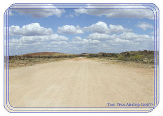
Tom Price Airport is an airport near Tom Price, in the Pilbara region of Western Australia. It has a short dirt runway capable of handing small general aviation aircraft and light turboprops.
Learmonth Airport is a civil airport, co-located on the site of RAAF Base Learmonth, a Royal Australian Air Force (RAAF) base. The airport is located near the town of Exmouth on the north-west coast of Western Australia, in Australia.
Derby Airport is located 5 nautical miles southeast of Derby, Western Australia.
Margaret River Airport is located in Bramley near Margaret River, Western Australia. It was established in 1981 and sealed in 1999.
Coolawanyah Station Airport is an airport located 5 kilometres (3.1 mi) west of Coolawanyah Station, in the Shire of Ashburton, part of the Pilbara region of Western Australia.

Exmouth Submarine Base, called Operation Potshot, was a United States Navy base at Exmouth Gulf, Western Australia during World War II. Exmouth Gulf on western Australia was selected as the site for US Naval base as it was thought at the time to be out of the reach of Empire of Japan's long-range bombers. Bombing of Darwin on February 19, 1942, demonstrated a more southern port was needed. The Submarine operation at Exmouth Gulf and the North West Cape was called Operation Potshot, named after the Potshot airfield that provided fighter plane cover for the base.