Otho, Iowa

Last updated

Otho, Iowa
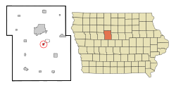
Webster County Iowa Incorporated and Unincorporated areas Otho Highlighted.svg
Location of Otho, Iowa
Coordinates: 42°25′29″N94°8′59″W / 42.42472°N 94.14972°W / 42.42472; -94.14972
Country Flag of the United States (23px).png  United States
State Flag of Iowa.svg  Iowa
County Webster
Area
[1]
  Total0.44 sq mi (1.15 km2)
  Land0.44 sq mi (1.15 km2)
  Water0.00 sq mi (0.00 km2)
Elevation
1,122 ft (342 m)
Population
 (2020)
  Total429
  Density968.40/sq mi (374.13/km2)
Time zone UTC-6 (Central (CST))
  Summer (DST) UTC-5 (CDT)
ZIP code
50569
Area code 515
FIPS code 19-60105
GNIS feature ID0459915

Otho is a city in Webster County, Iowa, United States. The population was 429 at the time of the 2020 census. [2]

Contents

Geography

Otho is located at 42°25′29″N94°8′59″W / 42.42472°N 94.14972°W / 42.42472; -94.14972 (42.424739, -94.149588). [3]

According to the United States Census Bureau, the city has a total area of 0.46 square miles (1.19 km2), all land. [4]

Demographics

Historical populations
YearPop.±%
1960 593    
1970 581−2.0%
1980 692+19.1%
1990 529−23.6%
2000 571+7.9%
2010 542−5.1%
2020 429−20.8%
Source: "U.S. Census website". United States Census Bureau . Retrieved March 29, 2020. and Iowa Data Center
Source:
U.S. Decennial Census [5] [2]

2020 census

As of the census of 2020, [6] there were 429 people, 226 households, and 120 families residing in the city. The population density was 969.0 inhabitants per square mile (374.1/km2). There were 245 housing units at an average density of 553.4 per square mile (213.7/km2). The racial makeup of the city was 93.7% White, 0.5% Black or African American, 0.9% Native American, 0.0% Asian, 0.0% Pacific Islander, 1.2% from other races and 3.7% from two or more races. Hispanic or Latino persons of any race comprised 3.5% of the population.

Of the 226 households, 22.6% of which had children under the age of 18 living with them, 36.3% were married couples living together, 10.2% were cohabitating couples, 24.8% had a female householder with no spouse or partner present and 28.8% had a male householder with no spouse or partner present. 46.9% of all households were non-families. 40.3% of all households were made up of individuals, 17.7% had someone living alone who was 65 years old or older.

The median age in the city was 47.8 years. 16.8% of the residents were under the age of 20; 4.9% were between the ages of 20 and 24; 25.2% were from 25 and 44; 31.0% were from 45 and 64; and 22.1% were 65 years of age or older. The gender makeup of the city was 52.2% male and 47.8% female.

2010 census

As of the census [7] of 2010, there were 542 people, 237 households, and 152 families living in the city. The population density was 1,178.3 inhabitants per square mile (454.9/km2). There were 260 housing units at an average density of 565.2 per square mile (218.2/km2). The racial makeup of the city was 97.6% White, 0.6% African American, 0.4% Native American, 0.2% Pacific Islander, 0.6% from other races, and 0.7% from two or more races. Hispanic or Latino of any race were 2.0% of the population.

There were 237 households, of which 28.7% had children under the age of 18 living with them, 50.2% were married couples living together, 8.9% had a female householder with no husband present, 5.1% had a male householder with no wife present, and 35.9% were non-families. 29.1% of all households were made up of individuals, and 12.7% had someone living alone who was 65 years of age or older. The average household size was 2.29 and the average family size was 2.80.

The median age in the city was 42.6 years. 22.1% of residents were under the age of 18; 8.5% were between the ages of 18 and 24; 22.2% were from 25 to 44; 30.3% were from 45 to 64; and 17% were 65 years of age or older. The gender makeup of the city was 52.2% male and 47.8% female.

2000 census

As of the census [8] of 2000, there were 571 people, 240 households, and 155 families living in the city. The population density was 1,281.2 inhabitants per square mile (494.7/km2). There were 245 housing units at an average density of 549.7 per square mile (212.2/km2). The racial makeup of the city was 97.20% White, 1.23% African American, 0.18% Native American, 0.18% Asian, 0.18% from other races, and 1.05% from two or more races. Hispanic or Latino of any race were 0.88% of the population.

There were 240 households, out of which 30.4% had children under the age of 18 living with them, 54.2% were married couples living together, 7.1% had a female householder with no husband present, and 35.4% were non-families. 30.0% of all households were made up of individuals, and 12.9% had someone living alone who was 65 years of age or older. The average household size was 2.38 and the average family size was 2.96.

26.3% were under the age of 18, 7.2% from 18 to 24, 27.5% from 25 to 44, 25.4% from 45 to 64, and 13.7% were 65 years of age or older. The median age was 39 years. For every 100 females, there were 100.4 males. For every 100 females age 18 and over, there were 97.7 males.

The median income for a household in the city was $34,318, and the median income for a family was $43,750. Males had a median income of $30,179 versus $22,375 for females. The per capita income for the city was $14,907. About 7.2% of families and 9.5% of the population were below the poverty line, including 11.6% of those under age 18 and 12.8% of those age 65 or over.

Education

Otho is within the Fort Dodge Community School District. [9] Otho residents are zoned to Butler Elementary School. [10] The district's sole secondary schools are Fort Dodge Middle School and Fort Dodge Senior High School.

Related Research Articles

<span class="mw-page-title-main">Pierceton, Indiana</span> Town in Indiana, United States

Pierceton is a town in Washington Township, Kosciusko County, in the U.S. state of Indiana. The population was 928 at the 2020 census.

<span class="mw-page-title-main">Fraser, Iowa</span> City in Iowa, United States

Fraser is a city in Dodge Township, Boone County, Iowa, United States. The population was 101 at the time of the 2020 census. It is part of the Boone, Iowa Micropolitan Statistical Area, which is a part of the larger Ames–Boone Combined Statistical Area. The city is located along the Des Moines River.

<span class="mw-page-title-main">Fairbank, Iowa</span> City in Iowa, United States

Fairbank is a city in Buchanan and Fayette counties in the U.S. state of Iowa. The population was 1,111 at the time of the 2020 census.

<span class="mw-page-title-main">Rinard, Iowa</span> City in Iowa, United States

Rinard is a city in Calhoun County, Iowa, United States. The population was 38 at the time of the 2020 census.

<span class="mw-page-title-main">Plover, Iowa</span> City in Iowa, United States

Plover is a city in Pocahontas County, Iowa, United States. The population was 50 at the time of the 2020 census.

<span class="mw-page-title-main">Badger, Iowa</span> City in Iowa, United States

Badger is a Town in Webster County, Iowa, United States. The population was 522 at the 2020 census. The town got its name from Badger Creek, which itself got its name when a group of soldiers from Fort Dodge in the early 1850s saw a badger for the first time.

<span class="mw-page-title-main">Moorland, Iowa</span> City in Iowa, United States

Moorland is a small town in Webster County, Iowa, United States. The population was 168 at the time of the 2020 census.

<span class="mw-page-title-main">Meade, Kansas</span> City in Meade County, Kansas

Meade is a city in and the county seat of Meade County, Kansas, United States. As of the 2020 census, the population of the city was 1,505.

<span class="mw-page-title-main">Ness City, Kansas</span> City in Ness County, Kansas

Ness City is a city in and the county seat of Ness County, Kansas, United States. As of the 2020 census, the population of the city was 1,329. Ness City is famous for its four-story Old Ness County Bank Building located downtown and nicknamed Skyscraper of the Plains.

<span class="mw-page-title-main">West Concord, Minnesota</span> City in Minnesota, United States

West Concord is a city in Dodge County, Minnesota, United States. The population was 861 at the 2020 census.

<span class="mw-page-title-main">Dodge, Nebraska</span> Village in Nebraska, United States

Dodge is a village in Dodge County, Nebraska, United States. The population was 612 at the 2010 census.

<span class="mw-page-title-main">Inglewood, Nebraska</span> Village in Nebraska, United States

Inglewood is a village in Dodge County, Nebraska, United States. The population was 325 at the 2010 census.

<span class="mw-page-title-main">Uehling, Nebraska</span> Village in Nebraska, United States

Uehling is a village in Dodge County, Nebraska, United States. The population was 230 at the 2010 census.

<span class="mw-page-title-main">Clarkson Valley, Missouri</span> City in Missouri, United States

Clarkson Valley is a city in St. Louis County, Missouri, United States. The population was 2,609 at the 2020 census.

<span class="mw-page-title-main">Dodge, North Dakota</span> City in North Dakota, United States

Dodge is a city in Dunn County, North Dakota, United States. The population was 89 at the 2020 census. Dodge was founded in 1915.

<span class="mw-page-title-main">Kekoskee, Wisconsin</span> Village in Wisconsin, United States

Kekoskee is a village in Dodge County, Wisconsin, United States. The population was 161 at the 2010 census.

<span class="mw-page-title-main">Blooming Prairie, Minnesota</span> City in Minnesota, United States

Blooming Prairie is a city in Dodge and Steele counties in the U.S. state of Minnesota. The population was 1,996 at the 2010 census. Most of the city is located within Steele County; only a small part of the city extends into Dodge County.

<span class="mw-page-title-main">Randolph, Wisconsin</span> Village in Wisconsin, United States

Randolph is a village in Columbia and Dodge Counties in the U.S. state of Wisconsin. The population was 1,811 at the 2010 census. Of this, 1,339 were in Dodge County, and 472 were in Columbia County. The village is located at the southeast corner of the Town of Randolph in Columbia County, although only a tiny portion of the village lies within the town. Most of the village lies within the Town of Westford in Dodge County. Small portions also lie within the Town of Fox Lake to the north and the Town of Courtland in Columbia County.

<span class="mw-page-title-main">Clyman, Wisconsin</span> Village in Wisconsin, United States

Clyman is a village in Dodge County, Wisconsin, United States. The population was 422 at the 2010 census. The village is located within the Town of Clyman.

<span class="mw-page-title-main">Fort Dodge, Kansas</span> Unincorporated community in Ford County, Kansas

Fort Dodge is a census-designated place (CDP) in Grandview Township, Ford County, Kansas, United States. As of the 2020 census, the population was 97. It is located on U.S. Route 400 5 miles (8 km) southeast of Dodge City. Fort Dodge has a post office with ZIP code 67843.

References

  1. "2020 U.S. Gazetteer Files". United States Census Bureau. Retrieved March 16, 2022.
  2. 1 2 "2020 Census State Redistricting Data". census.gov. United states Census Bureau. Retrieved August 12, 2021.
  3. "US Gazetteer files: 2010, 2000, and 1990". United States Census Bureau. February 12, 2011. Retrieved April 23, 2011.
  4. "US Gazetteer files 2010". United States Census Bureau. Archived from the original on January 25, 2012. Retrieved May 11, 2012.
  5. "Census of Population and Housing". Census.gov. Retrieved June 4, 2015.
  6. "2020 Census". United States Census Bureau.
  7. "U.S. Census website". United States Census Bureau . Retrieved May 11, 2012.
  8. "U.S. Census website". United States Census Bureau . Retrieved January 31, 2008.
  9. "Fort Dodge" (PDF). Iowa Department of Education . Retrieved April 5, 2020.
  10. "Elementary Boundary Map Final" (PDF). Fort Dodge Community School District . Retrieved April 5, 2020. - See text note in the lower left corner of the screen.