
Perivale is a mainly residential suburban town of Greater London, 9.5 miles (15.3 km) west of Charing Cross. It is the smallest of the seven towns which make up the London Borough of Ealing.

Medway is a unitary authority area with borough status in the ceremonial county of Kent in South East England. It was formed in 1998 by merging the boroughs of Rochester-upon-Medway and Gillingham, and is administered by Medway Council, which is independent from Kent County Council. The borough had a population of 278,016 in 2019. The borough contains the towns of Chatham, Gillingham, Rainham, Rochester and Strood, which are collectively known as the Medway Towns.
Snodland is a town in the borough of Tonbridge and Malling in Kent, England. It lies on the River Medway, between Rochester and Maidstone, and 27 miles (43 km) from central London. At the 2011 Census, it had a population of 10,211.

Gillingham is a town in the unitary authority area of Medway, in the ceremonial county of Kent, England. The town forms a conurbation with neighbouring towns Chatham, Rochester, Strood and Rainham. It is also the largest town in the borough of Medway. In 2020 it had a population of 108,785.

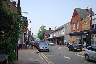
Rainham is a town in the unitary authority area of Medway, in the ceremonial county of Kent, England. The town forms a conurbation with neighbouring towns Chatham, Rochester, Strood and Gillingham.

Swanley is a town and civil parish in the Sevenoaks District of Kent, England, 16 miles (26 km) southeast of central London, adjacent to the Greater London boundary and within the M25 motorway periphery. The population at the 2021 census was 17,826.

Allington is an almost entirely modern village situated alongside the sides of the A20 road west of Maidstone in Kent, England. It is part of the built-up area of Maidstone.
Parkwood or Park Wood may refer to:

Walderslade is a large suburb in Kent in Chatham split between the unitary authority of Medway and the boroughs of Maidstone and Tonbridge & Malling in South East England. It was, until 1998, fully part of Kent and is still ceremonially associated via the Lieutenancies Act. It encompasses almost all the ME5 postcode district.

Rainham Marshes is an RSPB nature reserve in the east of London, adjacent to the Thames Estuary in Purfleet, Thurrock and the London Borough of Havering.

Gillingham and Rainham is a constituency in Kent represented in the House of Commons of the UK Parliament since 2024 by Naushabah Khan of the Labour Party. It was previously represented since its 2010 creation by Rehman Chishti of the Conservative Party and replaced the previous constituency of Gillingham.

The Saxon Shore Way is a long-distance footpath in England. It starts at Gravesend, Kent, and traces the coast of South-East England as it was in Roman times as far as Hastings, East Sussex, 163 miles (262 km) in total. This means that around Romney Marsh the route runs significantly inland from the modern coastline.

Hempstead is a village near Gillingham, Kent in South East England. Historically a small hamlet, Hempstead grew throughout the 20th century to become part of the urban area of the Medway Towns. Hempstead is located on the southern edge of the Unitary authority of Medway, surrounded by Wigmore and the A278 trunk road to the east, Capstone valley to the west and the M2 motorway and the village of Bredhurst to the south. Most of Hempstead is in a valley, with Hempstead Valley Drive running along its length with housing on both sides.
Twydall is a suburb of Gillingham in Kent in south-east England. In 1998 responsibility for local government was transferred from Kent County Council to the newly created Unitary Authority of Medway, The origin of the name Twydall is thought to mean "Two Parts" or "Double Portion" from the Old English twidǣl, but by 1240 it was written Twydele. Two Palmerston forts were built in the area, Grange Redoubt and Woodlands Redoubt: the design used came to be known as the Twydall Profile.

Wigmore is a suburb in the southeast of Medway in Kent, England. It is near Hempstead to the west and Rainham to the north east.
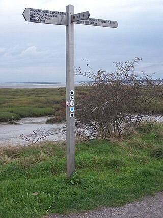
Riverside Country Park is a large coastal public park, situated alongside the River Medway estuary between Gillingham and Rainham. The park covers about 100 hectares. There are a variety of natural habitats within the park, including mudflats and salt marsh, ponds and reed-beds, grassland and scrub, which provide a haven for wildlife.

The Howard School is a boys' secondary school in Rainham, Kent, England, with approximately 1,500 pupils. It offers a partially selective system and is one of only five bi-lateral schools in the United Kingdom. The partially selective system permits admission to the grammar school section by the 11-Plus selection, however a passing mark is not required if the pupil is seen to have the ability to work in the 'grammar stream', and non-selective admission to the high school. The school is a Sports College.

Foxburrow Wood is a 6.1-hectare (15-acre) Local Nature Reserve in Rainham in Kent. It is owned and managed by Medway Council.

