
Coromandel, also called Coromandel Town to distinguish it from the wider district, is a town on the Coromandel Harbour, on the western side of the Coromandel Peninsula, which is in the North Island of New Zealand. It is 75 kilometres east of the city of Auckland, although the road between them, which winds around the Firth of Thames and Hauraki Gulf coasts, is 190 km long. The population was 1,870 as of June 2024.

Amberley is a town located in the Hurunui District in north Canterbury, on the east coast of the South Island of New Zealand. It is located on State Highway 1 approximately 50 km north of Christchurch. It is the seat of the Hurunui District Council. The nearest town to the north of Amberly via state highway one is Waipara (11 km) and the nearest town to the south is Leithfield (5.7 km).

Cheviot is a town in the Hurunui District of north Canterbury, on the east coast of the South Island of New Zealand. It is located on State Highway 1, approximately 112 kilometres (70 mi) north of Christchurch and 68 kilometres (42 mi) south of Kaikōura.

Tuatapere is a small rural town in Southland, New Zealand. It is the self declared "Sausage Capital of New Zealand". Tuatapere is located eight kilometres from the southern coast. The Waiau River flows through the town before reaching Te Waewae Bay, where it has its outflow into Foveaux Strait. The main local industries are forestry and farming.

The Kaikōura Ranges are two parallel ranges of mountains located in the Canterbury Region in the northeast of the South Island of New Zealand. The two ranges are visible from a great distance, including from the southern coast of the North Island.

Waipara is a wine and tourism district in Canterbury, New Zealand, on the banks of the Waipara River. Its name translates to "Muddy Water", wai meaning water and para meaning mud.

The Main North Line between Picton and Christchurch and the Main South Line between Lyttelton and Invercargill, running down the east coast of the South Island of New Zealand, are sometimes together referred to collectively as the South Island Main Trunk (SIMT). Construction of a line running the length of the east coast began in the 1860s and was completed all the way from Picton to Invercargill in 1945; the last sections being on the Main North Line south of Picton. The designation "South Island Main Trunk" originally referred to only that line between Christchurch and Invercargill.

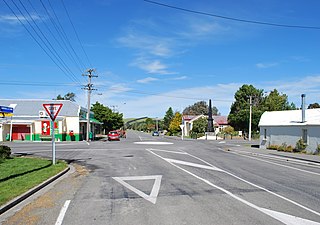
Waiau is a small town in north Canterbury, in the South Island of New Zealand. It lies 30 kilometres (19 mi) east of Hanmer Springs on the northern bank of the Waiau Uwha River, some 30 kilometres (19 mi) from the river's mouth. There is a small supermarket, a DIY store and a petrol station.
The Waiau Branch was a branch line railway in the northern Canterbury region of New Zealand's South Island. Known as the Great Northern Railway for its first few decades of life, the Waiau Branch was seen as part of a main line north but was ultimately superseded by a coastal route. Opened in stages from 1882 to 1919, the line closed in 1978 but a portion has been retained as the Weka Pass Railway.

Waikari is a small town in the Canterbury region of New Zealand's South Island.
Hawarden is a small town in the Canterbury region of New Zealand's South Island. It is located near Waikari, just off State Highway 7.

Culverden is a small town in the northern Canterbury region of New Zealand's South Island. It lies at the centre of the Amuri Plain. Culverden has traditionally been surrounded by sheep farms. Dairy farms have now become more common as a result of irrigation schemes in the area. The Waiau Plains Irrigation Scheme was completed in 1980. It provides irrigation to 17,000 hectares of farmland and the Balmoral Scheme provides irrigation to a further 5500 hectares.

Rotherham is a small village in the Hurunui District of the Canterbury region in New Zealand's South Island. It is between Culverden and Waiau on the Inland Kaikōura Road, on the northernmost part of the Amuri Plain. It lies near the south bank of the Waiau Uwha River, a popular location for trout and salmon fishing.

The Main North Line, sometimes referred to as part of the South Island Main Trunk railway, is a railway line that runs north from Christchurch in New Zealand up the east coast of the South Island through Kaikōura and Blenheim to Picton. It is a major link in New Zealand's national rail network and offers a connection with roll-on roll-off ferries from Picton to Wellington. It was also the longest railway construction project in New Zealand's history, with the first stages built in the 1870s and not completed until 1945.
The Culverden Express was a passenger train operated by the New Zealand Railways Department between Christchurch and Culverden. It ran from 1886 until its replacement by the Picton Express in 1945 and its route followed both the Main North Line and the Waiau Branch. In the mid-1920s, the main northern terminus became Parnassus, and to reflect this, the name was changed to the Parnassus Express.

Tāneatua is a small town in the Bay of Plenty region of New Zealand's North Island, 13 kilometres south of Whakatāne. State Highway 2 passes through the town on its route between Edgecumbe and Ōpōtiki. The small settlements of Ruatoki and Waimana are to the south and south-east of Tāneatua.
Hedgehope is a locality in the central Southland region of New Zealand's South Island.
Washdyke is an industrial suburb in the north of Timaru, in south Canterbury, New Zealand. State Highway 1 passes through Washdyke on the way north out of the city. The northern terminus of State Highway 8 is in Washdyke.

Waiau Pa is a small town of Auckland, New Zealand. It is in the Franklin Ward of Auckland Council. The name means "River of swirling currents" in the Māori language.
Waiau is a rural locality in the Western Bay of Plenty District of New Zealand. It is on the northern side of Tauranga Harbour, and is east and north from Waihi Beach and east of Athenree. Waiau River and State Highway 2 run through it.


