
The Au Sable River in Michigan, United States runs approximately 138 miles (222 km) through the northern Lower Peninsula, through the towns of Grayling and Mio, and enters Lake Huron at Au Sable. It is considered one of the best brown trout fisheries east of the Rockies and has been designated a blue ribbon trout stream by the Michigan Department of Natural Resources. In French, au sable literally means "at the sand." A 1795 map calls it the Beauais River.

The Holston River is a 136-mile (219 km) river that flows from Kingsport, Tennessee, to Knoxville, Tennessee. Along with its three major forks, it comprises a major river system that drains much of northeastern Tennessee, southwestern Virginia, and northwestern North Carolina. The Holston's confluence with the French Broad River at Knoxville marks the beginning of the Tennessee River.

The Maury River is a 42.8-mile-long (68.9 km) tributary of the James River in west-central Virginia in the United States. It is part of the watershed of Chesapeake Bay.

Seneca Creek is a 19.6-mile-long (31.5 km) tributary of the North Fork of the South Branch of the Potomac River located entirely within Pendleton County, West Virginia, USA.
Trough Creek State Park is a 554 acres (224 ha) Pennsylvania state park in Cass, Penn and Todd Townships, Huntingdon County, Pennsylvania in the United States. The majority of the park is in Todd Township along Pennsylvania Route 994, east of the unincorporated village of Entriken. Huntingdon is the nearest borough. The park borders Rothrock State Forest and Raystown Lake National Recreation Area. There is a growing population of bald eagles at the lake. Fourteen eagles were spotted in January 2007. This is up from two that were spotted in 1990, the first year that an eagle survey was taken. These three sections of state and federal owned property combine together to provide hunting, hiking and fishing opportunities for the outdoorsman.

Poe Paddy State Park is a 23-acre (9.3 ha) Pennsylvania state park in Haines Township, Centre County, Pennsylvania in the United States. The park is surrounded by Bald Eagle State Forest. Poe Valley State Park is 4 miles (6.4 km) to the east. The park is at the confluence of Big Poe Creek and Penns Creek. Poe Paddy State Park is named for the two mountains that surround it. Poe Mountain lies to the east and Paddy Mountain lies to the west, with Penns Creek in the valley between them.

Fort Valley is a mountain valley in Shenandoah County, Virginia. The so-called "valley within a valley" lies between the two arms of the northern Massanutten Mountain range in the Shenandoah Valley. The valley is closed at its southern end, and is constricted and nearly closed to the north, where Passage Creek flows through a narrow gap. The valley opens out toward the center, becoming about three miles (4.8 km) wide at its widest. In all, Fort Valley is 23 miles (37 km) long.

The Selway River is a large tributary of the Middle Fork of the Clearwater River in the U.S. state of Idaho. It flows within the Selway-Bitterroot Wilderness, the Bitterroot National Forest, and the Nez Perce National Forest of North Central Idaho. The entire length of the Selway was included by the United States Congress in 1968 as part of the National Wild and Scenic Rivers Act.

The Black River is a 114-mile-long (183 km) river in the White Mountains of the U.S. state of Arizona. It forms southwest of Alpine and flows southwest then northwest to meet the White River west of Fort Apache. The merged streams form the Salt River, a major tributary of the Gila River.
Tonto Creek is a 72.5-mile-long (116.7 km) stream located in the Mogollon Rim area of the state of Arizona on the north edge of the Tonto National Forest. The closest town, Payson, is 18 miles (29 km) away. Tonto Creek is a stream that flows year round, starting just below the Mogollon Rim, at the northern edge of Tonto National Forest. The creek continues its descent through the Hellsgate Wilderness area and eventually into a wide valley in the Sonoran Desert. It continues through the desert and into the Salt River within the north end of Theodore Roosevelt Lake. The facilities are maintained by Tonto National Forest division of the USDA Forest Service.

The Laurel Fork is a 15.7-mile-long (25.3 km) stream in Virginia and West Virginia, United States. The stream flows north from Highland County, Virginia, where its source and the majority of its length is located, to its mouth in Pendleton County, West Virginia. Laurel Fork is a tributary to the North Fork South Branch Potomac River, making it a part of the Potomac River watershed. The area surrounding Laurel Fork is home to several plant and animal species found nowhere else in Virginia, and is a prime example of a northern boreal forest in the state.
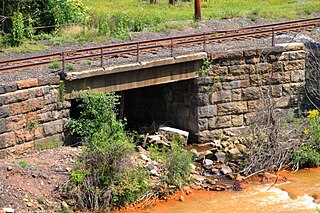
Trout Run is a tributary of Shamokin Creek in Northumberland County, Pennsylvania, in the United States. It is approximately 1.4 miles (2.3 km) long and flows through Coal Township. The watershed of the stream has an area of 3.01 square miles (7.8 km2). The stream is not designated as impaired and has a high level of water quality. It flows through a valley between Big Mountain and Little Mountain. A reservoir is located in the stream's watershed and it has been used as a water supply. The stream is designated as a Coldwater Fishery and a Migratory Fishery and supports aquatic life.

North Creek is a wildland in the George Washington and Jefferson National Forests of western Virginia that has been recognized by the Wilderness Society as a special place worthy of protection from logging and road construction. Tall evergreen and hardwood trees in the area around Apple Orchard Falls tower above ferns and wildflowers. The area includes a valley which extends from Sunset Fields in the east to its western border near the North Creek Camping Area.

James River Face Wilderness Addition is a wildland in the George Washington and Jefferson National Forests of western Virginia that has been recognized by the Wilderness Society as a special place worthy of protection from logging and road construction. Adjacent to the James River Face Wilderness, it extends the wildland opportunities of the wilderness on the east to the Jefferson National Forest boundary. The area, managed for bear, has hardwood forests with ages between 60 and almost 100 years.
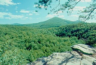
Cove Mountain is a wildland in the George Washington and Jefferson National Forests of western Virginia that has been recognized by the Wilderness Society as a special place worthy of protection from logging and road construction.

Mount Rogers Crest Zone is a wildland in the George Washington and Jefferson National Forests of western Virginia that has been recognized by the Wilderness Society as a special place worthy of protection from logging and road construction. The Wilderness Society has designated the area as a “Mountain Treasure”.
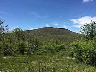
Whitetop Mountain is a wildland in the George Washington and Jefferson National Forests of western Virginia that has been recognized by the Wilderness Society as a special place worthy of protection from logging and road construction. The Wilderness Society has designated the area as a “Mountain Treasure”.
Rogers Ridge, a wildland in the George Washington and Jefferson National Forests of western Virginia and the Cherokee National Forest of eastern Tennessee, has been recognized by the Wilderness Society as a special place worthy of protection from logging and road construction. The Wilderness Society has designated the area as a “Mountain Treasure”.
London Bridge Branch, a wildland in the George Washington and Jefferson National Forests of western Virginia and the Cherokee National Forest of eastern Tennessee, has been recognized by the Wilderness Society as a special place worthy of protection from logging and road construction. The Wilderness Society has designated the area as a “Mountain Treasure”.


