
Peachtree City is the largest city in Fayette County, Georgia, United States. As of the 2010 United States Census, it had a population of 34,364. Peachtree City is located in South Metro Atlanta.
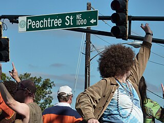
Peachtree Street is one of several major streets running through the city of Atlanta, Georgia, United States. Beginning at Five Points in downtown Atlanta, it runs North through Midtown; a few blocks after entering into Buckhead, the name changes to Peachtree Road at Deering Road. Much of the city's historic and noteworthy architecture is located along the street, and it is often used for annual parades,, as well as one-time parades celebrating events such as the 100th anniversary of Coca-Cola in 1986 and the Atlanta Braves' 1995 and 2021 World Series victories.
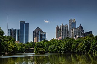
Midtown Atlanta, or Midtown, is a high-density commercial and residential neighborhood of Atlanta, Georgia. The exact geographical extent of the area is ill-defined due to differing definitions used by the city, residents, and local business groups. However, the commercial core of the area is anchored by a series of high-rise office buildings, condominiums, hotels, and high-end retail along Peachtree Street between North Avenue and 17th Street. Midtown, situated between Downtown to the south and Buckhead to the north, is the second-largest business district in Metro Atlanta. In 2011, Midtown had a resident population of 41,681 and a business population of 81,418.

Buckhead is the uptown commercial and residential district of the city of Atlanta, Georgia, comprising approximately the northernmost fifth of the city. Buckhead is the third largest business district within the Atlanta city limits, behind Downtown and Midtown, and a major commercial and financial center of the Southeast.
Peachtree, peach tree or variations may refer to:
From its incorporation in 1847, the municipal boundaries of Atlanta, Georgia, United States, were extended repeatedly from a small area around its railroad station to today's city covering 131.7 square miles (341 km2).

Accompanying Hurricane Katrina's catastrophic coastal impacts was a moderate tornado outbreak spawned by the cyclone's outer bands. The event spanned August 26–31, 2005, with 57 tornadoes touching down across 8 states. One person died and numerous communities suffered damage of varying degrees from central Mississippi to Pennsylvania, with Georgia sustaining record monetary damage for the month of August. Due to extreme devastation in coastal areas of Louisiana and Mississippi, multiple tornadoes may have been overlooked—overshadowed by the effects of storm surge and large-scale wind—and thus the full extent of the hurricane's tornado outbreak is uncertain. Furthermore, an indeterminate number of waterspouts likely formed throughout the life cycle of Hurricane Katrina.
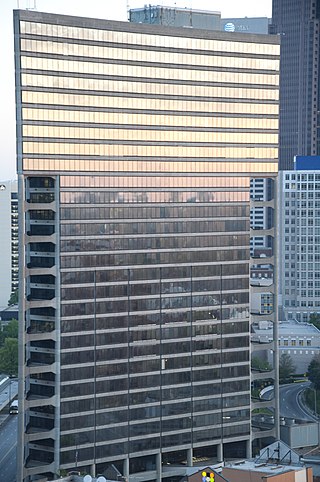
Peachtree Summit is a 125 m (410 ft), 31-story skyscraper in downtown Atlanta, Georgia. Completed in 1975, Peachtree Summit is shaped like a triangle due to the unusual shape of its building lot, which is hemmed in by the Downtown Connector, West Peachtree Street, and Ivan Allen Jr. Boulevard. The building has a direct connection to the Civic Center MARTA station and was built with a three-story lobby to account for the late 1970s elevation of West Peachtree Street for MARTA construction. This building was planned as the first of three similar buildings for the area, of which only this one was constructed.

Ponce de Leon Avenue, often simply called Ponce, provides a link between Atlanta, Decatur, Clarkston, and Stone Mountain, Georgia. It was named for Ponce de Leon Springs, in turn from explorer Juan Ponce de León, but is not pronounced as in Spanish. Several grand and historic buildings are located on the avenue.
Peachtree is an unincorporated community in Botetourt County, Virginia, United States.
Peachtree/Norwood is a Roanoke, Virginia neighborhood located in far northwest Roanoke. It borders the neighborhoods of Edgewood-Summit Hills on the south, Washington Heights and Westview Terrace on the east, Roanoke County on the north and the City of Salem on the west. The neighborhood is predominantly residential in character throughout its central area with commercial development along both its U.S. 460 and Virginia State Route 117 frontages. Its development patterns typical of those experienced for an American city during the mid-20th century with low-density housing.
Washington Heights is a Roanoke, Virginia neighborhood located in northwest Roanoke, bound to the west by Virginia State Route 117. It borders the neighborhoods of Peachtree/Norwood on the west, South Washington Heights on the south, Villa Heights on the east and Westview Terrace on the north. The neighborhood sees both a mix of residential development throughout its area spanning a more traditional grid street network in addition to more typical suburban ranch style construction.
The Southeast Region is one of ten United States regions that currently send teams to the Little League World Series, the largest youth baseball competition in the world. The region's participation in the LLWS dates back to 1957, when it was known as the South Region. However, when the LLWS was expanded in 2001 from eight teams to 16 teams, the Southern Region was split into the Southeast and Southwest Regions.

The Nine-Mile Circle was a streetcar line of the Atlanta Street Railway, later the Atlanta Consolidated Street Railway which went from downtown Atlanta to today's Virginia-Highland neighborhood as follows:

Streetcars originally operated in Atlanta downtown and into the surrounding areas from 1871 until the final line's closure in 1949.

Peachtree Park is a neighborhood in the Buckhead Community of Atlanta, Georgia.

Can This Be Dixie? is a 1936 American musical comedy film directed by George Marshall and featuring child star Jane Withers along with [Slim Summerville]] and Helen Wood.
The War Between the Provinces is a series of fantasy novels by Harry Turtledove.
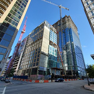
1105 West Peachtree is a mixed-use development in Atlanta, Georgia, United States. Located along West Peachtree Street in Midtown Atlanta, the development would consist primarily of a 32-story office building and a smaller residential tower called 40 West 12th.


