
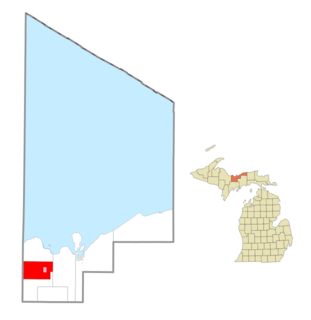
Onota Township is a civil township of Alger County in the U.S. state of Michigan. As of the 2010 census, the township population was 352.
Rock River Township is a civil township of Alger County in the U.S. state of Michigan. The population was 1,212 at the 2010 census.
The Advisory Committee on Antarctic Names is an advisory committee of the United States Board on Geographic Names responsible for recommending commemorative names for features in Antarctica.

The Forrestal Range is a largely snow-covered mountain range, about 105 km (65 mi) long, standing east of Dufek Massif and the Neptune Range in the Pensacola Mountains of Antarctica. Discovered and photographed on 13 January 1956 on a transcontinental patrol plane flight of U.S. Navy Operation Deep Freeze I from McMurdo Sound to the vicinity of the Weddell Sea and return.
Wichita Mountains Wildlife Refuge, located in southwestern Oklahoma near Lawton, has protected unique wildlife habitats since 1901 and is the oldest managed wildlife facility in the United States Fish and Wildlife Service system. The refuge's location in the geologically unique Wichita Mountains and its areas of undisturbed mixed grass prairie make it an important conservation area. The Wichitas are approximately 500 million years old. Measuring about 59,020 acres (238.8 km2), the refuge hosts a great diversity of species: 806 plant species, 240 species of birds, 36 fish, and 64 reptiles and amphibians are present.

Sedan is an unincorporated community in Hampshire County in the U.S. state of West Virginia. Sedan is located between Hanging Rock and Delray on Delray Road in the North River Valley. The community was named for the Battle of Sedan, shortly after the battle was fought during the Franco-Prussian War on September 1, 1870. A post office operated in Sedan from 1871 to 1935.

Viola is an unincorporated community on Route 39 on the border between Barry and Stone counties in the U.S. state of Missouri. Viola is also situated adjacent to Table Rock Lake between the Kings River arm to the west and the main White River portion of the lake to the north.
East Beckley was an unincorporated community located in Raleigh County, West Virginia. Its post office was reopened in February 2014. East Beckley comprised parts of the unincorporated communities of Sylvia and Atkinsville.

Vernon is an unincorporated community in McIntosh County, Oklahoma, United States. Its elevation is 696 feet (212 m).

Arlington is a census-designated place (CDP) in southeastern Carbon County, Wyoming, United States. The population was 25 at the 2010 census.
Sturgeon River is a 63.6-mile-long (102.4 km) river in the U.S. state of Michigan, flowing mostly southward through Alger County and Delta County counties on the Upper Peninsula.

Sulphur, Nevada, is a ghost town in Humboldt County, Nevada that was a Feather River Route station in the Black Rock Desert along the Kamma Mountains.
Weir is an unincorporated community in Kanawha County, West Virginia, United States. Its post office is called Falling Rock.

Diorite is an unincorporated community in Marquette County in the U.S. state of Michigan. The community is located within Ely Township. As an unincorporated community, Diorite has no legally defined boundaries or population statistics of its own.

Gordonsville is an unincorporated community in Shell Rock Township, Freeborn County, Minnesota, United States. It is southeast of Albert Lea, along U.S. Highway 65.
New Floodwood is an unincorporated community in Athens County, in the U.S. state of Ohio.
Raven Rock is an unincorporated community in Pleasants County, in the U.S. state of West Virginia.
Castle Rock is an extinct town in Osage County, in the U.S. state of Missouri. The townsite lies is located on the inside curve of an incised meander of the Osage River. The Castle Rock formation for which it was named lies across the river to the north in Cole County just southeast of Wardsville. The Pikes Camp Wildlife Area lies to the west across the river.
Flag is an extinct community in Taney County, in the U.S. state of Missouri. It was on the west side of the county, near the Stone County line, a bit north of the present day location of the Table Rock Dam.
White Rock is an extinct town in Elko County, in the U.S. state of Nevada.


