| Woodbay | |
|---|---|
| Unincorporated community | |
| Coordinates: 37°41′32″N81°15′54″W / 37.69222°N 81.26500°W Coordinates: 37°41′32″N81°15′54″W / 37.69222°N 81.26500°W | |
| Country | United States |
| State | West Virginia |
| County | Raleigh |
| Elevation | 1,936 ft (590 m) |
| Time zone | Eastern (EST) (UTC-5) |
| • Summer (DST) | EDT (UTC-4) |
| GNIS ID | 2747536 [1] |
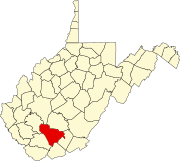
Woodbay was an unincorporated community and coal town in Raleigh County, West Virginia.

In law, an unincorporated area is a region of land that is not governed by a local municipal corporation; similarly an unincorporated community is a settlement that is not governed by its own local municipal corporation, but rather is administered as part of larger administrative divisions, such as a township, parish, borough, county, city, canton, state, province or country. Occasionally, municipalities dissolve or disincorporate, which may happen if they become fiscally insolvent, and services become the responsibility of a higher administration. Widespread unincorporated communities and areas are a distinguishing feature of the United States and Canada. In most other countries of the world, there are either no unincorporated areas at all, or these are very rare; typically remote, outlying, sparsely populated or uninhabited areas.
A coal town, also known as a coal camp or patch is typically situated in a remote place and provides residences for a population of miners to reside near a coal mine. A coal town is a type of company town or mining community established by the employer, a mining company, which imports workers to work the mineral find. The 'town founding' process is not limited to coal mining, nor mining, but is generally found where mineral wealth is located in a remote or undeveloped area, which is then opened for exploitation, normally first by having some transportation infrastructure brought into being first. Often, such minerals were the result of logging operations by pushing into a wilderness forest, which clear-cutting operations then allowed geologists and cartographers, to chart and plot the lands, allowing efficient discovery of natural resources and their exploitation.

Raleigh County is a county located in the U.S. state of West Virginia. As of the 2010 census, the population was 78,859. Its county seat is Beckley. The county was founded in 1850 and is named for Sir Walter Raleigh.


