Red House or The Red House may refer to:
A pear is a tree of the genus Pyrus and the fruit of that tree, edible in some species.
The following is a set–index article, providing a list of lists, for the cities, towns and villages within the jurisdictional United States. It is divided, alphabetically, according to the state, territory, or district name in which they are located.
Isaban is an unincorporated community located on Fourpole Creek, in McDowell and Mingo counties in the U.S. state of West Virginia.

Robert Lincoln Ramsay was an English-born American politician who served as a member of the United States House of Representatives for West Virginia's 1st congressional district from 1933 to 1939, 1941 to 1943, and 1949 to 1953.

Quick is a small unincorporated community in Kanawha County, West Virginia, United States. It is located along Indian Creek Road. The community is where Whitoak Fork and Blue Creek come together and meet. It is also where the abandoned railroad that follows Blue Creek joins the road, and follows it all the way to the community of Hitop, along Pond Fork. Its post office is closed.
Belva is an unincorporated community and census-designated place in west Nicholas County and north Fayette County, West Virginia, United States; while the CDP only includes the Nicholas County portion, the Fayette County portion is considered part of the community. The town is situated at the bottomland surrounding the convergence of Bells Creek with Twentymile Creek and, subsequently, Twenty Mile Creek with the Gauley River. Belva is also the location of the convergence of two state highways: West Virginia Route 16 and West Virginia Route 39.
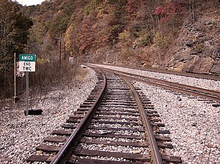
Amigo is an unincorporated community in Raleigh County, West Virginia, United States. The community is located on West Virginia Route 16 at the confluence of the Guyandotte River and Winding Gulf. The Amigo Post Office closed on October 22, 2011; it was established in 1915.

Pluto is an unincorporated community in Raleigh County, West Virginia. The elevation is 2,589 feet.
Surveyor is an unincorporated community in Raleigh County, West Virginia, United States. Surveyor is located on West Virginia Route 305, 7 miles (11 km) west of Beckley. Surveyor has a post office with ZIP code 25932.
Dickinson, also known as Quincy, is an unincorporated community in Kanawha County, West Virginia, United States. Dickinson is located on the north bank of the Kanawha River, 3 miles (4.8 km) southeast of Belle. The community is served by U.S. Route 60.
McAlpin is an unincorporated community in Raleigh County, West Virginia, United States. McAlpin is located on County Route 30 and Winding Gulf, 1.9 miles (3.1 km) west-southwest of Sophia.
Coco is an unincorporated community in Kanawha County, West Virginia, United States.
Cirtsville is an unincorporated community located in Raleigh County, West Virginia, United States. The community derives its name from Curt Vass, an early settler.
Lively is an unincorporated community in Fayette County, West Virginia, United States.
Legg is an unincorporated community in Kanawha County, West Virginia, United States. Its post office is closed.
Rensford is an unincorporated community in Kanawha County, West Virginia, United States. Its post office is closed. It was also known as Point Lick.
Jenky is an unincorporated community in Fayette County, West Virginia, United States.
Bryce is an unincorporated community in Fayette County, West Virginia, United States.
Wevaco is an unincorporated community and former coal town in Kanawha County, West Virginia, United States. It had a post office but is now closed.


