
Arch Alfred Moore Jr. was an American lawyer and Republican politician from West Virginia. He began his political career as a state legislator in 1952. He was elected the 28th and 30th Governor of West Virginia, serving from 1969 until 1977 and again from 1985 until 1989.

The Cacapon River, located in the Appalachian Mountains of West Virginia's Eastern Panhandle region, is an 81.0-mile-long (130.4 km) river known for its fishing, boating, wildlife, and scenery. As part of the Potomac River watershed, it is an American Heritage River.

Frenchburg is an unincorporated community in Hampshire County in the U.S. state of West Virginia. Frenchburg is located along the Northwestern Turnpike where the Little Cacapon River is formed by the confluence of the North and South forks of the Little Cacapon east of Shanks. Frenchburg is also the location of the southern terminus of Little Cacapon River Road on U.S. Route 50. Frenchburg is primarily known for the events that took place there during the American Civil War.

Mechanicsburg, also known as Mechanicsville, is an unincorporated community in Hampshire County, West Virginia, in the United States. It is located on the Northwestern Turnpike west of Romney at Mill Creek Gap. Mechanicsburg is the site of "The Burg", used as a headquarters by both armies during the American Civil War. Along Fox Hollow Road lies the 19th-century Fox's Hollow Baptist Church and the old Mechanicsburg School.

West Virginia Route 55 is an east–west state highway in West Virginia. The western terminus of the route is at U.S. Route 19 in Muddlety. The eastern terminus is at the Virginia state line six miles (10 km) east of Wardensville, where WV 55 continues as Virginia State Route 55. From Moorefield to the Virginia state line, WV 55 is concurrent with U.S. Route 48. This portion includes the Clifford Hollow Bridge.
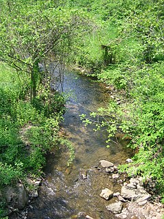
Dillons Run is a 12.9-mile-long (20.8 km) tributary stream of the Cacapon River, belonging to the Potomac River and Chesapeake Bay watersheds. The stream is located in Hampshire County in the U.S. state of West Virginia's Eastern Panhandle.

Meadow Branch is a 16.7-mile-long (26.9 km) tributary stream of Sleepy Creek in West Virginia's Eastern Panhandle region. It passes through the Sleepy Creek Wildlife Management Area, where it is dammed to form the 205-acre (0.83 km2) Sleepy Creek Lake.

Cacapon Mountain runs northwest through Morgan and Hampshire counties in West Virginia's Eastern Panhandle, rising to its greatest elevation of 2,618 feet (798 m) above sea-level at High Point. Cacapon Mountain is a folded mountain ridge, belonging to the Appalachian Ridge and Valley Province. Cacapon Mountain spans 16 miles (26 km) NNE to the Potomac River near Great Cacapon.

Cherry Run is a 7.2-mile-long (11.6 km) meandering stream that forms the northern section of the boundary between Morgan and Berkeley counties in West Virginia's Eastern Panhandle. While it is mostly non-navigable, Cherry Run provides many pools of varying depths for fishing and swimming. As a tributary of the Potomac River, Cherry Run is part of the Potomac and Chesapeake Bay watersheds.

Bloomery is an unincorporated community in Hampshire County in the U.S. state of West Virginia. Bloomery is located along the Bloomery Pike, northwest of Winchester, Virginia. According to the 2000 census, the Bloomery community has a population of 321.
Asco is an unincorporated community located in McDowell County, West Virginia, United States. Asco was originally known as Atlantic. The current name derives from the American Smokeless Coal Company (ASCO). It lies at the end of a line of the Norfolk and Western Railroad in Davy Branch hollow.
Dunlow is an unincorporated community in southern Wayne County, West Virginia, USA, on Twelvepole Creek. It was laid out as a railroad town along the Ohio Extension of the Norfolk and Western Railway in 1892. Dunlow was incorporated in 1892. However, the railroad up the West Fork of Twelvepole Creek through Dunlow was shut down in the early 1930s, and what is left of the town is currently unincorporated. At the 2000 census, Dunlow had a population of 1,105. In 2009, the population was listed as 961.
Green Spring Run is an 8.9-mile-long (14.3 km) tributary stream of the North Branch Potomac River in Hampshire County in the U.S. state of West Virginia. Green Spring Run rises in Greenwood Hollow north of Springfield and meanders northeast through Green Spring Valley. The South Branch Valley Railroad and Green Spring Road run parallel to the stream. It runs through the community of Green Spring, from which the stream takes its name. From Green Spring, Green Spring Run flows east where it reaches its confluence with the North Branch Potomac shortly before the North Branch joins with the South Branch Potomac River to form the Potomac River.
Isaacs Creek is a 15.0-mile-long (24.1 km) tributary stream of Back Creek in Frederick County, Virginia. Isaacs Creek rises on Timber Ridge at the boundary line with Hampshire County, West Virginia, and flows into Back Creek at Grave Hill shortly before Back Creek's confluence with Hogue Creek. The stream is dammed to create Lake Holiday.
Buffalo Creek is a 4.1-mile-long (6.6 km) free-flowing tributary stream of the South Branch Potomac River, itself a tributary of the Potomac River, making it a part of the Chesapeake Bay watershed. Buffalo Creek is located in west-central Hampshire County in the U.S. state of West Virginia. Because the stream flows through several small farms, Buffalo Creek primarily serves agriculture purposes with segments used for livestock watering.
Sharon is an unincorporated community and coal town in southeastern Kanawha County, West Virginia, United States, located along the West Virginia Turnpike.
Beards Fork is a census-designated place (CDP) and coal town in Fayette County, West Virginia, United States that was founded as a coal town. As of the 2010 census, its population was 199.

The North River is a tributary of the Cacapon River, belonging to the Potomac River and Chesapeake Bay watersheds. The river is located in Hampshire and Hardy counties in the U.S. state of West Virginia's Eastern Panhandle. The mouth of the North River into the Cacapon is located at Forks of Cacapon. From its headwaters to its mouth, the North River spans 52.4 miles (84.3 km) in length.
Mill Run is a 9.1-mile-long (14.6 km) tributary stream of the South Branch Potomac River, belonging to the Potomac River and Chesapeake Bay watersheds. The stream is located in Hampshire County in the Eastern Panhandle of the U.S. state of West Virginia. Mill Run rises on Nathaniel Mountain and flows northeast, then northwest into the South Branch south of Romney near Hampshire Park on South Branch River Road.
Loudendale is an unincorporated community in Kanawha County, West Virginia. It is near Kanawha State Forest with access to Charleston, the state capital, by way of Pennington Hill or Coal Hollow.


