
Raleigh County is a county in the U.S. state of West Virginia. As of the 2020 census, the population was 74,591. Its county seat is Beckley. The county was founded in 1850 and is named for Sir Walter Raleigh. Raleigh County is included in the Beckley, West Virginia Metropolitan Statistical Area.

Whitby is an unincorporated community and coal town in the Winding Gulf Coalfield of southern West Virginia within Raleigh County, United States.
Jonben is an unincorporated community and coal town within the Winding Gulf Coalfield and is located within Raleigh County, West Virginia, United States.

Fireco is an unincorporated community coal town in Raleigh County, West Virginia, United States. It lies in the Winding Gulf Coalfield of the southern part of the state. The name Fireco denotes the amount of heat the specific coal mined there could produce. This name was once a common descriptor.
The Winding Gulf Coalfield is located in western Raleigh County and eastern Wyoming County, in southern West Virginia. It is named after the Winding Gulf stream, a tributary of the Guyandotte River. In the early 20th century, it was promoted as the "Billion Dollar Coalfield".
The New River Coalfield is located in northeastern Raleigh County and southern Fayette County, West Virginia. Commercial mining of coal began in the 1870s and thrived into the 20th century. The coal in this field is a low volatile coal, known as "smokeless" coals. The seams of coal that have been mined include Sewell, Fire Creek, and Beckley. This is very high quality bituminous coal rated at approximately 15,000 BTU (16,000 kJ). The New River coalfield is named after the north flowing New River. Over 60 coal towns were once located there, supported by independent commercial districts at Beckley, Oak Hill, Mount Hope, and Fayetteville. By the 21st century many coal camps had partially or completely returned to nature. These company towns were located along Dunloup (Loup) Creek, Laurel Creek, White Oak Creek, lower Piney Creek, and, of course, the New River. The mainline of the Chesapeake and Ohio Railway ran right through the center of this coalfield, with spurs branching off in many directions, and rail yards were maintained at Quinnimont, Raleigh, and Thurmond, WV. The Virginian Railway's main line also passed through the western side of the field as well. Companies such as the New River Company, New River & Pocahontas Consolidated Coal Co., and Mary Frances Coal Co. were the largest operators in the New River Coalfield, but there were many smaller ones as well. These companies recruited native born whites, immigrants from Southern and Eastern Europe, and African-Americans from the South to work in their coal mines and railroads. The mines began to close down after World War II and today there are very few active coal mines in the field. The New River Gorge is now the domain of the National Park Service as the New River Gorge National Park and Preserve, and they have done what their budget allows to preserve the coal heritage of the area.

Pocahontas Coalfield, which is also known as the Flat Top-Pocahontas Coalfield, is located in Mercer County/McDowell County, West Virginia and Tazewell County, Virginia. The earliest mining of coal in the coalfield was in Pocahontas, Virginia in 1883 at Pocahontas Mine No. 1, now on the National Register of Historic Places.
Stotesbury is an unincorporated community and former coal town in Raleigh County in the U.S. state of West Virginia that flourished during the 1930s. The community was named for Edward T. Stotesbury, then the president of Beaver Coal Company.
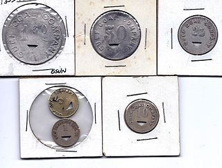
Hot Coal or Hotcoal was an unincorporated community and coal town located along the Winding Gulf Creek in Raleigh County, West Virginia, United States. Originally, it was named Patterson and later acquired the name Hot Coal. It was the next community past Big Stick on County Route 3/2. Although, the community now no longer exists, the Winding Gulf Bank, now the National Bank at Beckley, resided at Hot Coal and was moved to Beckley on January 1, 1914. Hot Coal at one time had a Post Office
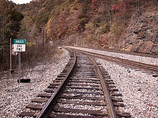
Amigo is an unincorporated community in Raleigh County, West Virginia, United States. The community is located on West Virginia Route 16 at the confluence of the Guyandotte River and Winding Gulf. The Amigo Post Office closed on October 22, 2011; it was established in 1915.

Helen is a census-designated place (CDP) in Raleigh County, West Virginia, United States. As of the 2010 census, its population was 219. West Virginia Route 16, Winding Gulf and railroad tracks run right through the community.

Tams is an unincorporated community in Raleigh County, West Virginia, United States. Tams is located on West Virginia Route 16 and Winding Gulf, 4 miles (6.4 km) southwest of Sophia.

Ury is an unincorporated community in Raleigh County, West Virginia, United States. Ury is located on West Virginia Route 16 and Winding Gulf, 3 miles (4.8 km) north of Rhodell.
Whitman is an unincorporated community in Logan County, West Virginia, United States. Whitman is 3 miles (4.8 km) southwest of Logan. Whitman has a post office with ZIP code 25652.
McAlpin is an unincorporated community in Raleigh County, West Virginia, United States. McAlpin is located on County Route 30 and Winding Gulf, 1.9 miles (3.1 km) west-southwest of Sophia.
Winding Gulf is a 15.5-mile (24.9 km) long tributary of the Guyandotte River in Raleigh County, West Virginia. Winding Gulf is part of the Mississippi River watershed via the Guyandotte and Ohio Rivers, and drains an area of 21.63 square miles (56.0 km2) in a rural area on the Allegheny Plateau.
The National Coal Heritage Area (NCHA) is a federally designated National Heritage Area encompassing a region of thirteen counties in West Virginia that were the source of "smokeless" bituminous coal through much of the 20th century. The National Heritage Area recognizes the area's cultural and historic qualities and serves to promote tourism, historic preservation and economic development in the region. The idea of the NCHA was first proposed in the early 1990s by Congressman Nick Rahall, and was established on November 12, 1996 by the 1996 Omnibus Parks and Public Lands Management Act. The designated area includes Boone, Cabell, Fayette, Logan, Lincoln, McDowell, Mercer, Mingo, Raleigh, Summers, and Wayne counties.
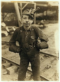
The coal mining communities, or coal towns of Raleigh County, West Virginia were situated to exploit the area's rich coal seams. Many of these towns were located in deep ravines that afforded direct access to the coal through the hillsides, allowing mined coal to be dropped or conveyed downhill to railway lines at the valley floor. Many of these encampments were set up as coal towns, and when their mines closed, the towns vanished. Raleigh County covers portions of three coalfields: the New River Coalfield, the Winding Gulf Coalfield and the Coal River Coalfield. Below is partial listing of known coal towns. Further listings are available here

Battleship is an unincorporated community located in Raleigh County, West Virginia, United States. Battleship has been known by two other names: Ralco and West Whitby. The community was part of the Winding Gulf Coalfield.
The Princeton–Deepwater District is a rail line in West Virginia that connects Deep Water, West Virginia, on the Kanawha River southwards to Princeton, West Virginia, and beyond to rail lines leading to Virginia. It is known for its rugged terrain and opportunities for rail photography.


