
The Ohio River is a 981-mile (1,579 km) long river in the midwestern United States that flows southwesterly from western Pennsylvania south of Lake Erie to its mouth on the Mississippi River at the southern tip of Illinois. It is the second largest river by discharge volume in the United States and the largest tributary by volume of the north-south flowing Mississippi River that divides the eastern from western United States. The river flows through or along the border of six states, and its drainage basin includes parts of 15 states. Through its largest tributary, the Tennessee River, the basin includes several states of the southeastern U.S. It is the source of drinking water for three million people.
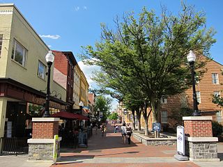
Winchester is an independent city located in the northwestern portion of the Commonwealth of Virginia in the United States. As of the 2010 census, the population was 26,203. As of 2015, its population is an estimated 27,284. It is the county seat of Frederick County, although the two are separate jurisdictions. The Bureau of Economic Analysis combines the city of Winchester with surrounding Frederick County for statistical purposes.

Rockingham County is a county located in the U.S. state of Virginia. As of the 2010 census, the population was 76,314. Its county seat is the independent city of Harrisonburg.

Highland County is a county located in the Commonwealth of Virginia. As of the 2010 census, the population was 2,321, in 2015, the population was estimated at 2,214. Its county seat is Monterey. Known as "Virginia's Switzerland" or "Virginia's Little Switzerland", Highland County is the least populous county in Virginia. Highland lays claim to being one of the least populous counties and one of the highest average elevations east of the Mississippi River.

The Shenandoah Valley is a geographic valley and cultural region of western Virginia and the Eastern Panhandle of West Virginia in the United States. The valley is bounded to the east by the Blue Ridge Mountains, to the west by the eastern front of the Ridge-and-Valley Appalachians, to the north by the Potomac River and to the south by the James River. The cultural region covers a larger area that includes all of the valley plus the Virginia highlands to the west, and the Roanoke Valley to the south. It is physiographically located within the Ridge and Valley province and is a portion of the Great Appalachian Valley.

The Monongahela River — often referred to locally as the Mon — is a 130-mile-long (210 km) river on the Allegheny Plateau in north-central West Virginia and southwestern Pennsylvania. The river flows from the confluence of its west and east forks in north central West Virginia northeasterly into southwestern Pennsylvania, then northerly to Pittsburgh and its confluence with the Allegheny River to form the Ohio River. The river is navigable its entire length via a series of locks and dams.

The Allegheny Mountain Range, informally the Alleghenies and also spelled Alleghany and Allegany, is part of the vast Appalachian Mountain Range of the Eastern United States and Canada and posed a significant barrier to land travel in less technologically advanced eras. The barrier range has a northeast–southwest orientation and runs for about 400 miles (640 km) from north-central Pennsylvania, through western Maryland and eastern West Virginia, to southwestern Virginia.

The Ridge-and-Valley Appalachians, also called the Ridge and Valley Province or the Valley and Ridge Appalachians, are a physiographic province of the larger Appalachian division and are also a belt within the Appalachian Mountains extending from southeastern New York through northwestern New Jersey, westward into Pennsylvania and southward into Maryland, West Virginia, Virginia, Kentucky, Tennessee, Georgia and Alabama. They form a broad arc between the Blue Ridge Mountains and the Appalachian Plateau physiographic province. They are characterized by long, even ridges, with long, continuous valleys in between.

The Shenandoah River is a tributary of the Potomac River, 55.6 miles (89.5 km) long with two forks approximately 100 miles (160 km) long each, in the U.S. states of Virginia and West Virginia. The principal tributary of the Potomac, the river and its tributaries drain the central and lower Shenandoah Valley and the Page Valley in the Appalachians on the west side of the Blue Ridge Mountains, in northwestern Virginia and the Eastern Panhandle of West Virginia.
The Potomac Highlands of West Virginia centers on five West Virginian counties in the upper Potomac River watershed in the western portion of the state's Eastern Panhandle, bordering Maryland and Virginia. Because of geographical proximity, similar topography and landscapes, and shared culture and history, the Potomac Highlands region also includes Pocahontas, Randolph, and Tucker counties, even though they are in the Monongahela River or New River watersheds and not that of the Potomac River.
Jarrold & Sons Ltd is a Norwich–based company that was founded in 1770 in Woodbridge, Suffolk. It moved to Norwich in 1823. It is privately owned, with members of the Jarrold family still having a significant involvement in running it.

Canaan Valley Resort State Park is a state park in the eastern United States, within Canaan Valley in Tucker County, West Virginia. Located in the highest valley east of the Mississippi River, the park contains the second-largest inland wetland area in the United States. The valley featured the first commercial ski development in West Virginia.
Valley Falls State Park is a 1,145 acre (4.63 km²) day use facility sited along both banks of the Tygart Valley River. The park is located about 7 miles (11 km) south of exit 137 of I-79, near Fairmont, West Virginia.
The West Virginia Department of Transportation is the state agency responsible for transportation in West Virginia. The Department of Transportation serves an umbrella organization for seven subsidiary agencies which are directly responsible for different areas of the state's infrastructure.
George Goodchild (1888–1969) aka Alan Dare, Wallace Q. Reid, and Jesse Templeton, was a prolific and successful British writer of popular books, short stories, plays, and movies, who published over 200 works in his 60-year career, and beyond his lifetime. Books are still re-issued, mostly in large print for older readers. Featured characters include Inspector McLean, spy catcher Q33 Trelawney, Nigel Rix, and Trooper O'Neill. He wrote and directed films based on books and stories, including Colorado Jack (1921), Bucking the Barrier (1923), The Public Defender (1931), Condemned to Death (1932), Trooper O'Neill (1932), and No Escape (1936).
The Big Coal Subdivision is a railroad line owned by CSX Transportation in the U.S. State of West Virginia. It was formerly part of the CSX Huntington East Division. It become part of the CSX Florence Division on June 20, 2016. The line runs from Whitesville, West Virginia to Sproul, West Virginia for a total of 35.6 miles. At its north end it continues south from the Big Marsh Fork Subdivision & Jarrolds Valley Subdivision and at its south end it continues south as the Coal River Subdivision.
The Jarrolds Valley Subdivision is a railroad line owned by CSX Transportation in the U.S. State of West Virginia. It was formerly part of the CSX Huntington East Division. It become part of the CSX Florence Division on June 20, 2016. The line runs from Whitesville, West Virginia to Clear Creek, West Virginia for a total of 15.3 miles. At its south end it continues north from the Big Coal Subdivision and at its north end the track comes to an end.
The Florence Division is a railroad division operated by CSX Transportation in the U.S. states of Georgia, Kentucky, North Carolina, South Carolina, Tennessee, Virginia & West Virginia. The Florence Division has 60 Subdivisions. The Subdivisions in italics came from the Huntington East & Huntington West Divisions effective June 20, 2016.


