Trap Hill | |
---|---|
Unincorporated community | |
Coordinates: 37°46′58″N81°20′36″W / 37.78278°N 81.34333°W Coordinates: 37°46′58″N81°20′36″W / 37.78278°N 81.34333°W | |
Country | United States |
State | West Virginia |
County | Raleigh |
Elevation | 1,972 ft (601 m) |
Time zone | Eastern (EST) (UTC-5) |
• Summer (DST) | EDT (UTC-4) |
GNIS ID | 1558397 [1] |
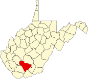
Trap Hill is an unincorporated community in Raleigh County, West Virginia, United States.
In law, an unincorporated area is a region of land that is not governed by a local municipal corporation; similarly an unincorporated community is a settlement that is not governed by its own local municipal corporation, but rather is administered as part of larger administrative divisions, such as a township, parish, borough, county, city, canton, state, province or country. Occasionally, municipalities dissolve or disincorporate, which may happen if they become fiscally insolvent, and services become the responsibility of a higher administration. Widespread unincorporated communities and areas are a distinguishing feature of the United States and Canada. In most other countries of the world, there are either no unincorporated areas at all, or these are very rare; typically remote, outlying, sparsely populated or uninhabited areas.
Raleigh County is a county located in the U.S. state of West Virginia. As of the 2010 census, the population was 78,859. Its county seat is Beckley. The county was founded in 1850 and is named for Sir Walter Raleigh.
West Virginia is a state located in the Appalachian region in the Southern United States and is also considered to be a part of the Middle Atlantic States. It is bordered by Pennsylvania to the north, Maryland to the east and northeast, Virginia to the southeast, Kentucky to the southwest, and Ohio to the northwest. West Virginia is the 41st largest state by area, and is ranked 38th in population. The capital and largest city is Charleston.
The Shenandoah River is a tributary of the Potomac River, 55.6 miles (89.5 km) long with two forks approximately 100 miles (160 km) long each, in the U.S. states of Virginia and West Virginia. The principal tributary of the Potomac, the river and its tributaries drain the central and lower Shenandoah Valley and the Page Valley in the Appalachians on the west side of the Blue Ridge Mountains, in northwestern Virginia and the Eastern Panhandle of West Virginia.
Wolf Pen is an unincorporated community in Wyoming County, West Virginia, United States, along Indian Creek.
The Huntington–Ashland metropolitan area is the largest metropolitan statistical area in West Virginia and includes seven counties across three states: West Virginia, Kentucky, and Ohio. New definitions from February 28, 2013 placed the population at 361,580. The MSA is nestled along the banks of the Ohio River within the Appalachian Plateau region. The area is referred to locally as the "Tri-State area". In addition, the three largest cities are referred to as the River Cities.
Becky Creek Wildlife Management Area is located on 1,930 acres (780 ha) south of Huttonsville in Randolph County, West Virginia. The terrain at Becky Creek is steep, and is covered with second-growth hardwood forest. Camping is permitted in the designated area. Camping is also available at nearby Kumbrabow State Forest.
Chief Cornstalk Wildlife Management Area is located on 11,772 acres (4,764 ha) in Mason County near Southside, West Virginia. Second growth oak-hickory and mixed hardwoods forests cover much of the rolling and moderately steep slopes. Chief Cornstalk WMA can be reached either on Nine Mile Creek Road off US 35 near Southside, or by Crab Creek Road from State Route 2, south of Gallipolis Ferry.
Conaway Run Lake Wildlife Management Area is located on 630 acres (250 ha) in Tyler County near Middlebourne, West Virginia. Mixed hardwoods forests and brush cover much of the hillsides surrounding the 30-acre Conaway Run Lake. Conaway Run Lake WMA can be reached on Conaway Run Road off West Virginia Route 18, about 10 miles (16 km) south of Middlebourne.
McClintic Wildlife Management Area, known locally as the "TNT area", is located in Mason County about 5 miles (8 km) north of Point Pleasant, West Virginia. Located on 3,655 acres (1,479 ha) of former wartime industrial land, the WMA is occupied by farmland, woodlands, and wetlands encompassing 31 ponds. The area still contains stored explosives.
Sand Hill Wildlife Management Area is located near Parkersburg, West Virginia in Wood and Ritchie counties. Sand Hill WMA is located on 1,987 acres (804 ha) of rugged, hilly oak-hickory woodlands interspersed with timber, oil and gas development sites.
Shannondale Springs Wildlife Management Area is located near Charles Town, West Virginia in Jefferson County. Shannondale Springs WMA is located on 1,361 acres (551 ha) of hills covered with oak-hickory woodlands, brushy areas, and open fields.
Sleepy Creek Wildlife Management Area is located in Morgan and Berkeley Counties in West Virginia's Eastern Panhandle. It encompasses 22,928 acres (92.79 km2), mostly covered with mixed oak and pine forest, although about 3,500 acres (14 km2) are covered with mixed hardwoods. The 205-acre (83 ha) Sleepy Creek Lake is located entirely within the WMA.
The 1988 State of the Union address was given by President Ronald Reagan to a joint session of the 100th United States Congress on Monday, January 25, 1988. The speech was the last State of the Union address of President Reagan's second term. Donald Hodel, the Secretary of the Interior, served as the designated survivor.
Clear Creek is an unincorporated community in Raleigh County, West Virginia, United States. Clear Creek is 4.5 miles (7.2 km) west of Pax. Clear Creek has a post office with ZIP code 25044.
Snow Hill is an unincorporated community in Kanawha County, West Virginia, United States. Snow Hill is 4 miles (6.4 km) southeast of downtown Charleston.
Liberty High School is a consolidated high school in rural Raleigh County, West Virginia, located in the town of Glen Daniel, West Virginia. The school, along with sister school and rival Independence High School was built in 1976, and the name is a reflection of that. The school was always intended to incorporate the previous Trap Hill, Clear Fork, and Marsh Fork high schools, but legal wrangling kept the later two from consolidation until the 1990s.
Crown Hill is an unincorporated community in Kanawha County, West Virginia, United States. Crown Hill is located on the south bank of the Kanawha River along West Virginia Route 61 1.8 miles (2.9 km) west-southwest of Pratt. Crown Hill once had a post office, which closed on February 1, 1997.
Trap Hill or Traphill may refer to:
Fairfax Pond-Rehe Wildlife Management Area is located on 638 acres (258 ha) south of Reedsville in Preston County, West Virginia. The wildlife management area is centered on a series of ponds and wetlands remaining from previous strip mining operations. The land was acquired in 2014.
Short Hills Wildlife Management Area is a 4,232-acre (17.13 km2) Wildlife Management Area (WMA) in Rockbridge and Botetourt counties, Virginia. It covers approximately 10 miles (16 km) of ridgeline along the Short Hills range.
Mattaponi Wildlife Management Area is a 2,542-acre (10.29 km2) Wildlife Management Area (WMA) in Caroline County, Virginia. Located west of Bowling Green, the area protects a mixture of wetlands and upland forests at the confluence of the Mattaponi and South rivers.
This article about a location in Raleigh County, West Virginia is a stub. You can help Wikipedia by expanding it. |