
Bukit Timah, often abbreviated as Bt Timah, is a planning area and residential estate located in the westernmost part of the Central Region of Singapore. Bukit Timah lies roughly 10 kilometres (6.2 mi) from the Central Business District, bordering the Central Water Catchment to the north, Bukit Panjang to the northwest, Queenstown to the south, Tanglin to the southeast, Clementi to the southwest, Novena to the east and Bukit Batok to the west.

Bishan, also known as Peck San, Bishan New Town or Bishan Town, is a planning area and matured residential town located at the northernmost portion of the Central Region of Singapore. Statistically, the area is ranked the 38th biggest in terms of geographical size and the 22nd most populated planning area in the country. It is located at the most Central point of Singapore, and it comprises Upper Thomson, Marymount, Shunfu, Sin Ming, Bishan North and Bishan East. There are also many private residential properties in Bishan. Bishan is ranked 15th in terms of population density. Apart from its boundary with the Central Water Catchment in the west, Bishan borders three other planning areas: Ang Mo Kio to the north, Toa Payoh to the south, and Serangoon to the east.

The Bukit Timah Nature Reserve is a 1.7-square-kilometre (0.66 sq mi) nature reserve near the geographic centre of Singapore, located on the slopes of Bukit Timah Hill, the country's highest natural peak standing at a height of approximately 165 metres (541 ft), and parts of the surrounding area, located actually in Bukit Panjang. The nature reserve is about 15 kilometres from the Downtown Core, Singapore's central business district (CBD).

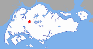
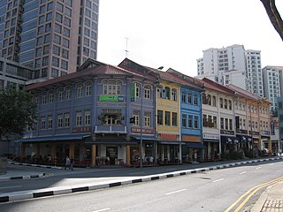
Outram is a planning area located within the Central Area of the Central Region of Singapore. The area is bordered by these planning areas: Singapore River to the north, the Downtown Core to the east and south, and Bukit Merah to the west. Outram comprises four subzones, China Square, Chinatown, People's Park and Pearl's Hill.
Bukit Gombak is a subzone of Bukit Batok, Singapore. It is a hilly neighbourhood in the west-central area of the Southeast Asian city-state of Singapore. In the Malay language, bukit means hill and gombak a bunch or collection of something. The neighbourhood consists of two hills. One of them stands at 133m while the other stands at 113m. They are Singapore's second and third highest natural point after Bukit Timah Hill.

Fort Canning Hill, or simply known as Fort Canning, is a prominent hill, about 48 metres (157 ft) high, in the southeast portion of Singapore, within the Central Area that forms Singapore's central business district.

The Singapore Land Authority (SLA) is a statutory board under the Ministry of Law of the Government of Singapore. SLA optimises land resources for Singapore's social and economic development.
River Valley is a planning area located within the Central Area of the Central Region of Singapore. The planning area shares boundaries with Orchard in the north, Museum in the east, Tanglin in the west, and Singapore River in the south.
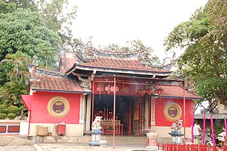
Tua Pek Kong is a Taoist deity in the pantheon of Peranakan folk religion practiced by ethnic Chinese in Malaysia, Singapore, and parts of Indonesia.
Sembawang Park is a 15-hectare park situated in Sembawang, in the north of Singapore facing the Straits of Johor overlooking Malaysia. It is located at the end of Sembawang Road, where the former Sembawang Road End Bus Terminal was.

The Ministry of Home Affairs, sometimes referred to as the Home Team, is a ministry of the Government of Singapore responsible for overseeing the national security, public security, civil defence, border control and immigration of Singapore.

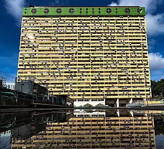
Pearl Bank Apartments was a high-rise private residential building on Pearl's Hill in Outram, near the Chinatown area of Singapore.
People's Park Complex is a high-rise commercial and residential building in Singapore, situated in Park Road off Eu Tong Sen Street in Outram, within People's Park and next to Chinatown MRT station.

Kent Ridge Park is a 47-hectare public park located in Kent Ridge, Singapore, between the National University of Singapore and the Singapore Science Park. Due to its undisturbed habitat and abundant plant life, it is a popular venue for bird-watchers and eco-tourists.

The Southern Ridges comprise 10 kilometres (6.2 mi) of trails connecting three parks along the southern ridge of Singapore. Some of the attractions along these trails include its greenery and the connecting bridges. This project linked up the parks between the Kent Ridge Park and HarbourFront. The idea to link these parks was coined in 2002 by Urban Redevelopment Authority (URA) and it took 2 years to complete and cost S$25.5 million.

The National Orchid Garden, located within the Singapore Botanic Gardens, was opened on 20 October 1995 by Senior Minister Lee Kuan Yew.
Kent Ridge is the name of a ridge and a neighbourhood located in Pasir Panjang, in the Queenstown Planning Area of Singapore. The area is notable for housing two parks within the Southern Ridges, Kent Ridge Park and HortPark. The main campus of the National University of Singapore is located adjacent to it, straddling along the southern boundary of Kent Ridge. It is served by the Kent Ridge MRT station.
Pearl's Hill, briefly Mount Stamford, is a small hill in Singapore. Located in the vicinity of Chinatown, it is one of the few surviving hills in the city area.
People's Park railway station was a railway station which served the People's Park area on the Singapore-Kranji Railway from somewhere between 1907 and 1909 to somewhere between 1929 and 1932.
