
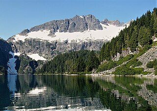
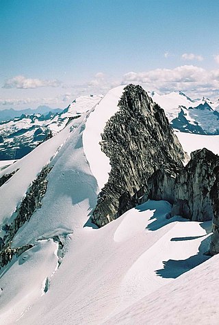
Joffre Peak is a 2,721-metre (8,927-foot) mountain summit located in the Coast Mountains, in Joffre Lakes Provincial Park, in southwestern British Columbia, Canada. It is the second-highest point of the Joffre Group, which is a subset of the Lillooet Ranges. It is situated 26 km (16 mi) east of Pemberton and 11 km (7 mi) northeast of Lillooet Lake. Joffre is more notable for its steep rise above local terrain than for its absolute elevation as topographic relief is significant with the summit rising 1,500 meters (4,920 ft) above Cayoosh Creek in 4 km (2.5 mi). The nearest higher peak is Mount Matier, 1.6 km (1 mi) to the south. The mountain's climate supports the Matier Glacier on the southwest slope, and the Anniversary Glacier on the southeast slope. Precipitation runoff from the peak drains into Joffre Creek and Cayoosh Creek which are both within the Fraser River watershed.
Lydia Mountain is a 2,100-metre (6,890-foot) summit located in the Tantalus Range, in Tantalus Provincial Park, in southwestern British Columbia, Canada. It is situated 14.5 km (9 mi) northwest of Squamish, and 5.46 km (3 mi) south-southeast of Mount Tantalus, which is the highest peak in the Tantalus Range. The nearest higher neighbor is The Red Tusk, 0.5 km (0 mi) to the west, and Mount Niobe lies 2.17 km (1 mi) to the east-southeast. Lake Lovely Water lies below the eastern slope of the peak and precipitation runoff from the peak drains east to the Squamish River, and west to the Clowhom River via Red Tusk Creek. Topographic relief is significant as Lydia Mountain rises 1,400 meters (4,600 feet) above Red Tusk Creek in approximately three kilometers (two miles). The mountain's name was officially adopted on June 6, 1957, by the Geographical Names Board of Canada. The mountain was named for mythic Lydia, of which Tantalus was a primordial ruler in Greek mythology. Several peaks in the Tantalus Range are named in association with Tantalus. The first ascent of Lydia Mountain was made in 1914 by Basil Darling and Allan Morkill.

Spearman Peak is a 3,365-metre (11,040-foot) summit located in British Columbia, Canada.
Mount Carr is a 2,590-metre (8,497-foot) mountain summit located in British Columbia, Canada.

Handcar Peak is a 2,338-metre (7,671-foot) mountain summit located in the Railroad Group of the Coast Mountains, in the Pemberton Valley of southwestern British Columbia, Canada. It is situated 38 km (24 mi) northwest of Pemberton and 3 km (2 mi) west of Locomotive Mountain. Precipitation runoff from the peak drains into Sampson Creek and Buck Creek which are both tributaries of the Lillooet River. Handcar Peak is more notable for its steep rise above local terrain than for its absolute elevation as topographic relief is significant with the summit rising over 2,050 meters (6,725 ft) above Lillooet River and Pemberton Valley in approximately 4 km (2.5 mi). The mountain's name was proposed in 1978 by mountaineer Karl Ricker of the Alpine Club of Canada, in association with Railroad Pass, Railroad Creek and other railroad-related names of the immediate vicinity. The toponym was officially adopted January 23, 1979, by the Geographical Names Board of Canada.
Face Mountain is a 2,485-metre (8,153-foot) mountain summit located in British Columbia, Canada.

Ipsoot Mountain is a 2,576-metre (8,451-foot) glaciated summit located in southwest British Columbia, Canada.

Phalanx Mountain is a 2,441-metre (8,009-foot) summit located in Garibaldi Provincial Park of southwest British Columbia, Canada.
Meslilloet Mountain is a 1,990-metre (6,529-foot) summit located in British Columbia, Canada.

Goat Peak is a 2,473-metre (8,114-foot) summit located in the Pemberton Valley of British Columbia, Canada.

Sun God Mountain is a 2,421-metre (7,943-foot) summit located in British Columbia, Canada.
Isosceles Peak is a 2,488-metre (8,163-foot) mountain summit located in British Columbia, Canada.
Vantage Peak is a 2,235-metre (7,333-foot) mountain summit located in the Coast Mountains of British Columbia, Canada. It is part of the Joffre Group, which is a subset of the Lillooet Ranges. It is situated 28.5 km (18 mi) east of Pemberton on the boundary of the Nlháxten/Cerise Creek Conservancy. Precipitation runoff from the peak drains southwest into Twin One Creek thence Lillooet Lake; the north slope drains into headwaters of Cerise Creek; and the east slope drains into Caspar Creek thence Cayoosh Creek which is within the Fraser River watershed. Vantage Peak is more notable for its steep rise above local terrain than for its absolute elevation as topographic relief is significant with the summit rising 1,135 meters (3,724 ft) above Twin One Creek in 4 km (2.5 mi). The nearest higher neighbor is Mount Duke, 2.08 km (1 mi) to the southeast.

Mount Howard is a 2,551-metre (8,369-foot) mountain summit located in the Coast Mountains of British Columbia, Canada. It is part of the Joffre Group, which is a subset of the Lillooet Ranges. Mount Howard is situated 27 km (17 mi) east of Pemberton and immediately southeast of Mount Matier. Precipitation runoff from the peak drains into Twin One Creek thence Lillooet Lake which is within the Lillooet River watershed. Mount Howard is more notable for its steep rise above local terrain than for its absolute elevation as topographic relief is significant with the summit rising 1,650 meters (5,413 ft) above Twin One Creek in 4 km (2.5 mi).

Oscar Peak is a 2,336-metre (7,664-foot) mountain summit located in British Columbia, Canada.
Whirlwind Peak is a 2,427-metre (7,963-foot) mountain summit in southwestern British Columbia, Canada.

Hour Peak is a 2,329-metre (7,641-foot) mountain summit located in British Columbia, Canada.
Parapet Peak is a 2,463-metre (8,081-foot) mountain summit located in British Columbia, Canada.

Corrie Peak is a 2,263-metre (7,425-foot) summit in British Columbia, Canada.

Remote Mountain is a 3,038-metre (9,967-foot) summit located in British Columbia, Canada.


