
Mercer County is a county located in the U.S. state of New Jersey. Its county seat is Trenton, also the state capital, prompting its nickname The Capital County. Mercer County alone constitutes the Trenton–Princeton metropolitan statistical area and is considered part of the New York metropolitan area by the U.S. Census Bureau, but also directly borders the Philadelphia metropolitan area and is included within the Federal Communications Commission's Philadelphia designated media market. As of the 2020 census, Mercer County's population was 387,340, retaining its position as the state's 12th-most populous county, an increase of 20,827 (5.7%) from the 2010 census when its population was 366,513. The county was formed by an act of the New Jersey Legislature on February 22, 1838, from portions of Burlington County, Hunterdon County, and Middlesex County,. The former Keith Line bisects the county and is the boundary between municipalities that previously had been separated into West Jersey and East Jersey.

Chesterfield, originally known as Recklesstown, is an unincorporated community located around the intersection of County Route 528 and County Route 677 in Chesterfield Township of Burlington County, New Jersey.

Aldie is an unincorporated community and census-designated place (CDP) located between Chantilly and Middleburg in Loudoun County, Virginia, United States. The historic village of Aldie is located on the John Mosby Highway in a gap between the Catoctin Mountains and Bull Run Mountains, through which the Little River flows. Aldie traditionally serves as the gateway to the Loudoun Valley and beyond. Aldie Virginia's County is Loudoun County, Aka the richest county in the country.

County Route 571 is a county highway in the U.S. state of New Jersey. The highway extends 43.96 miles (70.75 km) from Route 37 in Toms River Township to Route 27 in Princeton. Though it is designated a north–south county route by the New Jersey Department of Transportation (NJDOT), it is signed both as north–south and east–west inconsistently.
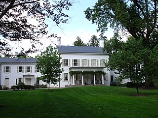
Morven, known officially as Morven Museum & Garden, is a historic 18th-century house at 55 Stockton Street in Princeton, Mercer County, New Jersey, United States. It served as the governor's mansion for nearly four decades in the twentieth century, and has been designated a National Historic Landmark for its association with Richard Stockton (1730-1781), a signer of the United States Declaration of Independence.
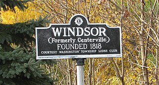
Windsor is a small historic unincorporated community located within Robbinsville Township in Mercer County, New Jersey, United States. The area is served as United States Postal Service ZIP Code 08561. There are approximately 50 homes in the area, and as of the 2010 United States Census, the population for ZIP Code Tabulation Area 08561 was 226. The community, covering 570 acres (230 ha), was added to the National Register of Historic Places in 1992.

The Princeton Battlefield in Princeton, Mercer County, New Jersey, United States, is where American and British troops fought each other on January 3, 1777 in the Battle of Princeton during the American Revolutionary War. The battle ended when the British soldiers in Nassau Hall surrendered. This success, following those at the Battle of Trenton on December 26, 1776 and the Battle of the Assunpink Creek the day before, helped improve American morale.

Prospect House, known also as just Prospect, is a historic house on the Princeton University campus in Princeton, Mercer County, New Jersey, United States. Built in 1851, it is a fine example of the work of architect John Notman who helped popularize Italianate architecture in America. Notable residents include Woodrow Wilson during his tenure as president of the university. The building now serves as a faculty club. It was designated a National Historic Landmark in 1985 for its architecture and historic associations.

The President's House, also known as the John Maclean House, or simply the Maclean House, in Princeton, Mercer County, New Jersey, United States, was built to serve as the home of the President of the College of New Jersey, which later became Princeton University. It was completed in 1756, the same year as Nassau Hall. United States Founding Father John Witherspoon lived here from 1768 through 1779, during which time he served as a delegate to the Continental Congress and signed the Declaration of Independence. George Washington occupied Maclean House in January 1777, during the Battle of Princeton and in 1783 while Congress met in Nassau Hall.

Upper Freehold Baptist Meeting, also known as Ye Olde Yellow Meeting House, is a historic church located on Yellow Meetinghouse and Red Valley roads in the Red Valley section of Upper Freehold Township near Imlaystown in Monmouth County, New Jersey. It is the oldest Baptist meetinghouse in the state. It was added to the National Register of Historic Places on April 21, 1975 for its significance in religion and exploration/settlement.

Manahawkin Baptist Church, also known as the Free Church of Manahawkin, is a historic Church in the Manahawkin section of Stafford Township in Ocean County, New Jersey. The Church was added to the National Register of Historic Places on April 3, 1973, for its significance in education, military history, and religion.

Welsh Tract Old School Baptist Church is a historic Primitive Baptist church, located on Welsh Tract Road in Newark, New Castle County, Delaware. It was built by Welsh settlers in 1746 and is a simple rectangular brick building with a wood-shingled jerkinhead roof.
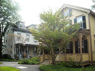
The Princeton Historic District is a 370-acre (150 ha) historic district located in Princeton, New Jersey that was listed on the U.S. National Register of Historic Places in 1975. It stretches from Marquand Park in the west to the Eating Clubs in the East, from the Princeton Cemetery in the north to the Graduate College in the south. The district encompasses the core parts of the campuses of the Princeton Theological Seminary and Princeton University. It also includes the business district centered on Nassau Street and many historic homes, both mansions in the western section and more humble dwellings in the Witherspoon/Jackson neighborhood. Notable churches within the district include Nassau Presbyterian Church, Trinity Episcopal, Nassau Christian Center, and the Princeton University Chapel. The district is home to seven of Princeton's nine, and New Jersey's fifty-eight, National Historic Landmarks, the largest concentration of such sites in the state.

Penns Neck is an unincorporated community located within West Windsor Township in Mercer County, New Jersey, United States. The community developed at the intersection of the Trenton-New Brunswick Turnpike and Washington Road. The Penns Neck Circle and the historic Penns Neck Baptist Church (1812) are both located in Penns Neck. The Princeton Branch rail line, known as the Dinky, has run through the area since 1865, and stopped at Penns Neck station until January 1971.

The Kingston Mill Historic District is a 49-acre (20 ha) historic district in Kingston, New Jersey. It is roughly bounded by Herrontown, River, and Princeton-Kingston Roads in the townships of Princeton in Mercer County, South Brunswick in Middlesex County, and Franklin in Somerset County. It was added to the National Register of Historic Places on April 10, 1986 for its significance in engineering, exploration/settlement, industry, and transportation. The district includes 16 contributing buildings and 2 contributing structures.

The Princeton Ice Company built a dam in 1884 on former farmland so as to allow for the production of ice for sale to residents and businesses in Princeton, New Jersey. This company was the primary supplier of ice to the town during the era of the frozen water trade before the advent of artificial refrigeration. In 1902 a second dam was added so as to increase ice production capacity. The company dissolved itself in 1929, after technological change rendered the ice trade obsolete. The nearly 77 acres (31 ha) site has gone undisturbed in the decades since, apart from the 1958 addition of a colonial revival home designed by noted local architect, Rolf Bauhan.

Tusculum is a country estate on Cherry Hill Road in Princeton, New Jersey, built in 1773 for John Witherspoon, president of Princeton University and signer of the Declaration of Independence. It is named after the Roman town of Tusculum, which was home to the country villa of Marcus Tullius Cicero. The property was often visited by George Washington and his wife, Martha, during Witherspoon's tenure as president of Princeton University. In 2013 the home was sold for $5.5 million.

The Washington Road Elm Allée is a 0.7-mile-long (1.1 km) stretch of Washington Road in West Windsor, New Jersey that is lined with Princeton Elm trees. The allée runs through the West Windsor fields of Princeton University and provides, along with the bridge over Lake Carnegie, a dramatic entrance to the campus. The Delaware and Raritan Canal can be found at the northern end of the allée, just before the lake. A jogging path runs through the allée and connects to the canal towpath, the main campus of the university, and other trails through the adjacent fields.

Washington Valley is an unincorporated community in the Whippany River valley within Morris Township in Morris County, New Jersey.

Old Bridge, also known as the Historic Village of Old Bridge, is an unincorporated community located within East Brunswick in Middlesex County, New Jersey. It is on the South River, a tributary of the Raritan River. The community is named after the first bridge built here to cross the river, the South River Bridge. After other bridges were built crossing the river, it became known as the Old Bridge. The Old Bridge Historic District, encompassing much of the village, is listed on the state and national registers of historic places.


