Pierpont, South Dakota

Last updated

Pierpont, South Dakota
PierpontAerial.jpg
Aerial photograph of Pierpont,
Nickname: 
Pierpont Panthers
Day County South Dakota Incorporated and Unincorporated areas Pierpont Highlighted.svg
Location in Day County and the state of South Dakota
Coordinates: 45°29′43″N97°49′56″W / 45.49528°N 97.83222°W / 45.49528; -97.83222
Country United States
State South Dakota
County Day
Area
[1]
  Total0.15 sq mi (0.39 km2)
  Land0.15 sq mi (0.39 km2)
  Water0.00 sq mi (0.00 km2)
Elevation
[2]
1,509 ft (460 m)
Population
 (2020) [3]
  Total129
  Density865.77/sq mi (334.14/km2)
Time zone UTC-6 (Central (CST))
  Summer (DST) UTC-5 (CDT)
ZIP code
57468
Area code 605
FIPS code 46-49540 [4]
GNIS feature ID1267532 [2]

Pierpont is a town in northwestern Day County, South Dakota, United States. The population was 129 at the 2020 census. [5]

Contents

The town was founded in 1883 and takes its name from a railroad officer. [6]

Geography

According to the United States Census Bureau, the town has a total area of 0.15 square miles (0.39 km2), all land. [7]

Demographics

Historical population
CensusPop.Note
1910 314
1920 40027.4%
1930 379−5.2%
1940 362−4.5%
1950 326−9.9%
1960 258−20.9%
1970 241−6.6%
1980 184−23.7%
1990 173−6.0%
2000 122−29.5%
2010 13510.7%
2020 129−4.4%
U.S. Decennial Census [8] [3]

2010 census

As of the census [9] of 2010, there were 135 people, 67 households, and 35 families residing in the town. The population density was 900.0 inhabitants per square mile (347.5/km2). There were 78 housing units at an average density of 520.0 per square mile (200.8/km2). The racial makeup of the town was 95.6% White, 0.7% African American, 1.5% Native American, 1.5% from other races, and 0.7% from two or more races. Hispanic or Latino of any race were 1.5% of the population.

There were 67 households, of which 17.9% had children under the age of 18 living with them, 43.3% were married couples living together, 4.5% had a female householder with no husband present, 4.5% had a male householder with no wife present, and 47.8% were non-families. 43.3% of all households were made up of individuals, and 20.9% had someone living alone who was 65 years of age or older. The average household size was 2.01 and the average family size was 2.71.

The median age in the town was 47.8 years. 21.5% of residents were under the age of 18; 3.7% were between the ages of 18 and 24; 19.2% were from 25 to 44; 34.1% were from 45 to 64; and 21.5% were 65 years of age or older. The gender makeup of the town was 54.8% male and 45.2% female.

2000 census

As of the census [4] of 2000, there were 122 people, 64 households, and 32 families residing in the town. The population density was 816.5 inhabitants per square mile (315.3/km2). There were 83 housing units at an average density of 555.5 per square mile (214.5/km2). The racial makeup of the town was 99.18% White and 0.82% Native American.

There were 64 households, out of which 14.1% had children under the age of 18 living with them, 43.8% were married couples living together, 3.1% had a female householder with no husband present, and 50.0% were non-families. 46.9% of all households were made up of individuals, and 29.7% had someone living alone who was 65 years of age or older. The average household size was 1.91 and the average family size was 2.63.

In the town, the population was spread out, with 15.6% under the age of 18, 2.5% from 18 to 24, 23.0% from 25 to 44, 23.8% from 45 to 64, and 35.2% who were 65 years of age or older. The median age was 50 years. For every 100 females, there were 100.0 males. For every 100 females age 18 and over, there were 114.6 males.

The median income for a household in the town was $29,464, and the median income for a family was $40,417. Males had a median income of $23,125 versus $18,438 for females. The per capita income for the town was $15,955. There were no families and 4.1% of the population living below the poverty line, including no under eighteens and 9.6% of those over 64.

Education

Pierpont Public School housed grades K-12 from 1898 through 1969 when the high school was consolidated with the Langford School District and the Claremont, SD School District. [10]

See also

Related Research Articles

<span class="mw-page-title-main">Yale, South Dakota</span> Town in South Dakota, United States

Yale is an incorporated town in Beadle County, South Dakota, United States. The population was 112 at the 2020 census.

<span class="mw-page-title-main">Sinai, South Dakota</span> Town in South Dakota, United States

Sinai is a town in Brookings County, South Dakota, United States. The population was 99 at the 2020 census. Located there are a grainery, a post office, a bank, and a church.

<span class="mw-page-title-main">Westport, South Dakota</span> Town in South Dakota, United States

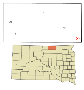
Westport is a town in western Brown County, South Dakota, United States. The population was 88 at the 2020 census.

<span class="mw-page-title-main">Wagner, South Dakota</span> City in South Dakota, United States

Wagner is a city in Charles Mix County, South Dakota, United States. The population was 1,490 at the 2020 census. The city is served by Wagner Municipal Airport as well as YST Transit buses.

<span class="mw-page-title-main">Bradley, South Dakota</span> Town in South Dakota, United States

Bradley is a town in Clark County, South Dakota, United States. The population was 65 at the 2020 census.

<span class="mw-page-title-main">Garden City, South Dakota</span> Town in South Dakota, United States

Garden City is a town in Clark County, South Dakota, United States. The population was 33 at the 2020 census.

<span class="mw-page-title-main">Andover, South Dakota</span> Town in South Dakota, United States

Andover is a town in northwestern Day County, South Dakota, United States. The population was 66 at the 2020 census.

<span class="mw-page-title-main">Butler, South Dakota</span> Town in South Dakota, United States

Butler is a town in Day County, South Dakota, United States. The population was 4 at the 2020 census.

<span class="mw-page-title-main">Marvin, South Dakota</span> Town in South Dakota, United States

Marvin is a town in Grant County, South Dakota, United States. The population was 19 at the 2020 census.

<span class="mw-page-title-main">Revillo, South Dakota</span> Town in South Dakota, United States

Revillo is a town in southeastern Grant County, South Dakota, United States. The population was 99 at the 2020 census.

<span class="mw-page-title-main">Hazel, South Dakota</span> Town in South Dakota, United States

Hazel is a town in Hamlin County, South Dakota, United States. It is part of the Watertown, South Dakota Micropolitan Statistical Area. The population was 102 at the 2020 census.

<span class="mw-page-title-main">Olivet, South Dakota</span> Town in South Dakota, United States

Olivet is a town in and the county seat of Hutchinson County, South Dakota. The population was 64 at the time of the 2020 census.

<span class="mw-page-title-main">Fairview, South Dakota</span> Town in South Dakota, United States

Fairview is a town in Lincoln County, South Dakota, United States. The population was 61 at the 2020 census.

<span class="mw-page-title-main">Eden, South Dakota</span> Town in South Dakota, United States

Eden is a town in Marshall County, South Dakota, United States. The population was 94 at the 2020 census.

<span class="mw-page-title-main">Langford, South Dakota</span> Town in South Dakota, United States

Langford is a town in Marshall County, South Dakota, United States. The population was 283 at the 2020 census.

<span class="mw-page-title-main">Sherman, South Dakota</span> Town in South Dakota, United States

Sherman is a town in Minnehaha County, South Dakota, United States. The population was 81 at the 2020 census.

<span class="mw-page-title-main">Claire City, South Dakota</span> Town in South Dakota, United States

Claire City is a town in Roberts County, South Dakota, United States. The population was 82 at the 2020 census.

<span class="mw-page-title-main">Corona, South Dakota</span> Town in South Dakota, United States

Corona is a town in Roberts County, South Dakota, United States. The population was 69 at the 2020 census.

<span class="mw-page-title-main">Rosholt, South Dakota</span> Town in South Dakota, United States

Rosholt is a town in Roberts County, South Dakota, United States. The population was 379 at the 2020 census.

<span class="mw-page-title-main">Lesterville, South Dakota</span> Town in South Dakota, United States

Lesterville is a town in Yankton County, South Dakota, United States. The population was 115 at the 2020 census.

References

  1. "ArcGIS REST Services Directory". United States Census Bureau. Retrieved October 15, 2022.
  2. 1 2 U.S. Geological Survey Geographic Names Information System: Pierpont, South Dakota
  3. 1 2 "Census Population API". United States Census Bureau. Retrieved October 15, 2022.
  4. 1 2 "U.S. Census website". United States Census Bureau . Retrieved January 31, 2008.
  5. "U.S. Census Bureau: Pierpont town, South Dakota". www.census.gov. United States Census Bureau. Retrieved March 22, 2022.
  6. Federal Writers' Project (1940). South Dakota place-names, v.1-3. University of South Dakota. p. 56.
  7. "US Gazetteer files 2010". United States Census Bureau. Archived from the original on January 25, 2012. Retrieved June 21, 2012.
  8. "Census of Population and Housing". Census.gov. Retrieved June 4, 2015.
  9. "U.S. Census website". United States Census Bureau . Retrieved June 21, 2012.
  10. Pierpont Public School website

Commons-logo.svg Media related to Pierpont, South Dakota at Wikimedia Commons