
Flagstaff is the county seat of Coconino County, Arizona, in the southwestern United States. As of the 2020 United States census, the city's population was 76,831.

Apache County is a county in the northeast corner of the U.S. state of Arizona. Shaped in a long rectangle running north to south, as of the 2020 census, its population was 66,021. The county seat is St. Johns.

Coconino County is a county in the North-Central part of the U.S. state of Arizona. Its population was 145,101 at the 2020 census. The county seat is Flagstaff. The county takes its name from Cohonino, a name applied to the Havasupai people. It is the second-largest county by area in the contiguous United States, behind San Bernardino County, California. It has 18,661 sq mi (48,300 km2), or 16.4% of Arizona's total area, and is larger than the nine smallest states in the U.S.

Navajo County is a county in the northern part of the U.S. state of Arizona. As of the 2020 census, its population was 106,717. The county seat is Holbrook.

Yavapai County is a county near the center of the U.S. state of Arizona. As of the 2020 census, its population was 236,209, making it the fourth-most populous county in Arizona. The county seat is Prescott.
Holbrook is a city in Navajo County, Arizona, United States. According to the 2010 census, the population of the city was 5,053. The city is the county seat of Navajo County.
The Apache are several Southern Athabaskan language–speaking peoples of the Southwest, the Southern Plains and Northern Mexico. They are linguistically related to the Navajo. They migrated from the Athabascan homelands in the north into the Southwest between 1000 and 1500 CE.

Diné College is a public tribal land-grant college based in Tsaile, Arizona, serving the 27,000-square-mile (70,000 km2) Navajo Nation. It offers associate degrees, bachelor's degrees, and academic certificates.
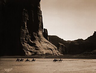
Canyon de Chelly National Monument was established on April 1, 1931, as a unit of the National Park Service. Located in northeastern Arizona, it is within the boundaries of the Navajo Nation and lies in the Four Corners region. Reflecting one of the longest continuously inhabited landscapes of North America, it preserves ruins of the indigenous tribes that lived in the area, from the Ancestral Puebloans to the Navajo. The monument covers 83,840 acres and encompasses the floors and rims of the three major canyons: de Chelly, del Muerto, and Monument. These canyons were cut by streams with headwaters in the Chuska Mountains just to the east of the monument. None of the land is federally owned. Canyon de Chelly is one of the most visited national monuments in the United States.

Northern Arizona is an unofficial, colloquially defined region of the U.S. state of Arizona. Generally consisting of Apache, Coconino, Mohave, Navajo, and Yavapai counties, the region is geographically dominated by the Colorado Plateau, the southern border of which in Arizona is called the Mogollon Rim.
Window Rock High School is a public high school in Fort Defiance, a census-designated place in unincorporated Apache County, Arizona. WRHS is the only high school in the Window Rock Unified School District.

U.S. Route 89 (US 89) is a U.S. Highway in the U.S. state of Arizona that begins in Flagstaff and heads north to the Utah border northwest of Page. US 89 is among the first U.S. Highways established in Arizona between November 11, 1926 and September 9, 1927. Until 1992, US 89 started at the international border in Nogales and was routed through Tucson, Phoenix and Prescott between Nogales and Flagstaff. State Route 79 and State Route 89 are both former sections of US 89.

Two Guns is a ghost town in Coconino County, Arizona, United States. Located on the east rim of Canyon Diablo about 30 mi (48 km) east of Flagstaff, Two Guns prospered as a tourist stop along Route 66.
Lupton is an unincorporated community and census-designated place (CDP) in Apache County, Arizona, United States. Lupton is located along Interstate 40 at the New Mexico border, 21 miles (34 km) southwest of Gallup, New Mexico. Lupton has a post office with ZIP code 86508. As of the 2010 census, the Lupton CDP had a population of 25.

The Bureau of Indian Education (BIE), headquartered in the Main Interior Building in Washington, D.C., and formerly known as the Office of Indian Education Programs (OIEP), is a division of the U.S. Department of the Interior under the Assistant Secretary for Indian Affairs. It is responsible for the line direction and management of all BIE education functions, including the formation of policies and procedures, the supervision of all program activities, and the approval of the expenditure of funds appropriated for BIE education functions.

Black Creek of Arizona is a 55-mi (89 km) long north tributary of the Puerco River, in northeast Arizona and northwest New Mexico.
Oak Springs is a census-designated place (CDP) in Apache County, Arizona, United States. The population was 63 at the 2010 census.
Indian Pine is a populated place situated in Navajo County, Arizona, United States. It has an estimated elevation of 7,175 feet (2,187 m) above sea level.
Navajo is a populated place situated in Apache County, Arizona, United States. It has an estimated elevation of 5,676 feet (1,730 m) above sea level.
Wheatfields is a populated place situated in Apache County, Arizona, United States, right along the border with New Mexico. It has an estimated elevation of 7,287 feet (2,221 m) above sea level. It is one of two places in Arizona with this name, the other being a CDP in Gila County. In 1909, the US Government set up an irrigation project to assist the Navajo residents. It is a chapter of the Navajo Nation.


