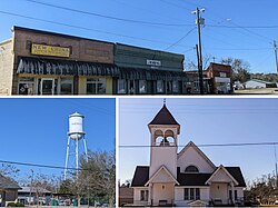
Pinewood, South Carolina | |
---|---|
Coordinates: 33°44′22″N80°27′48″W / 33.73944°N 80.46333°W | |
Country | United States |
State | South Carolina |
County | Sumter |
Area | |
• Total | 1.07 sq mi (2.77 km2) |
• Land | 1.07 sq mi (2.77 km2) |
• Water | 0.00 sq mi (0.00 km2) |
Elevation | 190 ft (60 m) |
Population | |
• Total | 503 |
• Density | 469.65/sq mi (181.35/km2) |
Time zone | UTC-5 (Eastern (EST)) |
• Summer (DST) | UTC-4 (EDT) |
ZIP code | 29125 |
Area code(s) | 803 and 839 |
FIPS code | 45-57085 [3] |
GNIS feature ID | 1231662 [4] |
Pinewood is a town located on South Carolina Highway 261 at the southern entrance to the High Hills of Santee in Sumter County, South Carolina, United States. The population was 538 at the 2010 census. It is included in the Sumter, South Carolina Metropolitan Statistical Area.
Millford Plantation, Pinewood Depot, and St. Mark's Episcopal Church are listed on the National Register of Historic Places. [5]
Pinewood is located at 33°44′22″N80°27′48″W / 33.73944°N 80.46333°W (33.739475, -80.463326). [6]
According to the United States Census Bureau, the town has a total area of 1.1 square miles (2.8 km2), all land.
Census | Pop. | Note | %± |
---|---|---|---|
1900 | 97 | — | |
1910 | 424 | 337.1% | |
1920 | 338 | −20.3% | |
1930 | 400 | 18.3% | |
1940 | 456 | 14.0% | |
1950 | 578 | 26.8% | |
1960 | 570 | −1.4% | |
1970 | 687 | 20.5% | |
1980 | 689 | 0.3% | |
1990 | 600 | −12.9% | |
2000 | 459 | −23.5% | |
2010 | 538 | 17.2% | |
2020 | 503 | −6.5% | |
U.S. Decennial Census [7] [2] |
At the 2000 census there were 459 people, 190 households, and 130 families in the town. The population density was 429.7 inhabitants per square mile (165.9/km2). There were 237 housing units at an average density of 221.9 per square mile (85.7/km2). The racial makeup of the town was 43.14% White, 56.43% African American, 0.22% Asian, and 0.22% from two or more races. Hispanic or Latino of any race were 0.22%. [3]
Of the 190 households 29.5% had children under the age of 18 living with them, 41.6% were married couples living together, 20.5% had a female householder with no husband present, and 31.1% were non-families. 30.5% of households were one person and 18.4% were one person aged 65 or older. The average household size was 2.42 and the average family size was 2.98.
The age distribution was 26.1% under the age of 18, 7.0% from 18 to 24, 24.4% from 25 to 44, 22.4% from 45 to 64, and 20.0% 65 or older. The median age was 40 years. For every 100 females, there were 80.0 males. For every 100 females age 18 and over, there were 70.4 males.
The median household income was $19,583 and the median family income was $29,688. Males had a median income of $31,750 versus $16,902 for females. The per capita income for the town was $10,853. About 15.8% of families and 19.7% of the population were below the poverty line, including 17.9% of those under age 18 and 31.1% of those age 65 or over.
Pinewood is an unincorporated community and census-designated place (CDP) in Miami-Dade County, Florida, United States. It is part of the Miami metropolitan area of South Florida. The population was 17,246 at the 2020 census.
Shenorock is a hamlet and census-designated place (CDP) located in the town of Somers in Westchester County, New York, United States. The population was 1,898 at the 2010 census.
Perry is a town in Aiken County, South Carolina, United States. The population was 233 at the 2010 census. It is part of the Augusta, Georgia metropolitan area.
Great Falls is a town in Chester County, South Carolina, United States and is located fourteen miles southwest of Lancaster, South Carolina. The population was 1,951 at the 2020 census.
Paxville is a town in Clarendon County, South Carolina, United States. The population was 185 at the 2010 census, down from 248 in 2000. The town was named after Joseph Pack.
Santee is a town in Orangeburg County along the Santee River Valley in central South Carolina, United States. It has become a resort town of note located centrally north-south along the Atlantic Seaboard of South Carolina. The region has been rural, with a primarily agricultural economy typical of Orangeburg County, but is now known primarily for its several golf courses in proximity to Lake Marion, Santee State Park and other Lake Marion attractions. Interstate 95 connects its attractions easily with tourists traveling by automobile. I-95 crosses a narrow arm of the lake into the town lands, along a causeway. Lake Marion is a man-made hydroelectric reservoir, which at 110,000 acres is one of the fifty largest lakes in the country.
Cane Savannah is a census-designated place (CDP) in Sumter County, South Carolina, United States. The population was 1,452 at the 2000 census. It is included in the Sumter, South Carolina Metropolitan Statistical Area.
Cherryvale is a census-designated place (CDP) in Sumter County, South Carolina, United States. The population was 2,461 at the 2000 census. It is included in the Sumter, South Carolina Metropolitan Statistical Area.
Dalzell is a census-designated place (CDP) in Sumter County, South Carolina, United States. The population was 3,175 at the 2020 census. It is included in the Sumter, South Carolina Metropolitan Statistical Area.
East Sumter is a census-designated place (CDP) in Sumter County, South Carolina, United States. The population was 1,220 at the 2000 census. It is included in the Sumter, South Carolina Metropolitan Statistical Area.
Lakewood is a census-designated place (CDP) in Sumter County, South Carolina, United States. The population was 2,603 at the 2000 census. It is included in the Sumter, South Carolina Metropolitan Statistical Area.
Millwood is a census-designated place (CDP) in Sumter County, South Carolina, United States. The population was 885 at the 2000 census. It is included in the Sumter, South Carolina Metropolitan Statistical Area.
Mulberry is a census-designated place (CDP) in Sumter County, South Carolina, United States. The population was 841 at the 2000 census. It is included in the Sumter, South Carolina Metropolitan Statistical Area.
Oakland is a census-designated place (CDP) in Sumter County, South Carolina, United States. The population was 1,272 at the 2000 census. It is included in the Sumter, South Carolina Metropolitan Statistical Area. Part of the area of the census-designated place is located within the Stateburg Historic District
Privateer is a census-designated place (CDP) in Sumter County, South Carolina, United States. The population was 2,118 at the 2000 census. It is included in the Sumter, South Carolina Metropolitan Statistical Area.
Rembert is a town in Sumter County, South Carolina, United States. The population was 306 at the 2010 census, a decline from 406 in 2000. It is included in the Sumter, South Carolina Metropolitan Statistical Area.
Shiloh is a census-designated place (CDP) in Sumter County, South Carolina, United States. The population was 259 at the 2000 census. It is included in the Sumter, South Carolina Metropolitan Statistical Area.
South Sumter is a census-designated place (CDP) in Sumter County, South Carolina, United States. The population was 3,365 at the 2000 census. It is included in the Sumter, South Carolina Metropolitan Statistical Area.
Stateburg is a census-designated place (CDP) in the High Hills of Santee in Sumter County, South Carolina, United States. The population was 1,380 at the 2010 census. It is included in the Sumter, South Carolina Metropolitan Statistical Area. Stateburg is located within the larger Stateburg Historic District.
Wedgefield is a census-designated place (CDP) in Sumter County, South Carolina, United States. The population was 1,544 at the 2000 census.