Piz Nair | |
---|---|
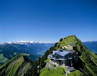
Piz Nair cable car station in 2006 | |
Highest point | |
Elevation | 3,056 m (10,026 ft) |
Prominence | 183 m (600 ft) [1] |
Parent peak | Piz Ot |
Coordinates | 46°30′22.5″N9°47′14.8″E / 46.506250°N 9.787444°E Coordinates: 46°30′22.5″N9°47′14.8″E / 46.506250°N 9.787444°E |
Geography | |
Location | Graubünden, Switzerland |
Parent range | Albula Alps |
Climbing | |
Easiest route | Cable car |
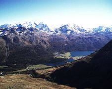
Piz Nair (3,056 metres (10,026 ft)) is a mountain of the Albula Alps in Switzerland, overlooking St. Moritz in the canton of Graubünden. The peak is easily accessible from the village with a funicular and a cable car; the upper station unloads 30 metres (100 ft) below the summit. Below the summit to the east is the Corviglia ski area.
A mountain is a large landform that rises above the surrounding land in a limited area, usually in the form of a peak. A mountain is generally steeper than a hill. Mountains are formed through tectonic forces or volcanism. These forces can locally raise the surface of the earth. Mountains erode slowly through the action of rivers, weather conditions, and glaciers. A few mountains are isolated summits, but most occur in huge mountain ranges.
The Albula Alps are a mountain range in the Alps of eastern Switzerland. They are considered to be part of the Central Eastern Alps, more specifically the Western Rhaetian Alps. They are named after the river Albula. The Albula Alps are separated from the Oberhalbstein Alps in the west by the Septimer Pass and the valley of the Sursés; from the Plessur Alps in the north-west by the Landwasser valley; from the Silvretta group in the north-east by the Flüela Pass; from the Bernina Range in the south-east by the Maloja Pass and the Inn valley.
Switzerland, officially the Swiss Confederation, is a country situated in western, central, and southern Europe. It consists of 26 cantons, and the city of Bern as the seat of the federal authorities. The sovereign state is a federal republic bordered by Italy to the south, France to the west, Germany to the north, and Austria and Liechtenstein to the east. Switzerland is a landlocked country geographically divided between the Alps, the Swiss Plateau and the Jura, spanning a total area of 41,285 km2 (15,940 sq mi). While the Alps occupy the greater part of the territory, the Swiss population of approximately 8.5 million people is concentrated mostly on the plateau, where the largest cities are to be found: among them are the two global cities and economic centres Zürich and Geneva.
The mountain hosted the alpine skiing events for the 1948 Winter Olympics in neighboring St. Moritz. [2] It also hosted the World Championships in 1934, 1974, 2003 and 2017.
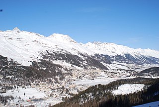
At the 1948 Winter Olympics in St. Moritz, Switzerland, the six alpine skiing events were held on Piz Nair from Monday, 2 February to Thursday, 5 February 1948.
The 1948 Winter Olympics, officially known as the V Olympic Winter Games, was a winter multi-sport event celebrated in 1948 in St. Moritz, Switzerland.
The FIS Alpine World Ski Championships are an alpine skiing competition organized by the International Ski Federation (FIS).
Corviglia is a location on the eastern slopes of Piz Nair, overlooking St. Moritz in the canton of Graubünden. It lies on the watershed between the rivers Schlattain and the Ovel da la Resgia, at an elevation of 2,486 m (8,156 ft). Corviglia is mainly accessible from the town by the St. Moritz–Corviglia funicular, via Chantarella. At Corviglia, an aerial tramway climbs west to Piz Nair, unloading slightly below its summit.
The St. Moritz–Corviglia Funicular is a funicular railway in the canton of Graubünden, Switzerland. The line links the town of St. Moritz with the Corviglia summit and ski area, and comprises two sections of differing gauge, with passengers changing cars at the intermediate station of Chantarella.
The Alpine region of Switzerland, conventionally referred to as the Swiss Alps, represents a major natural feature of the country and is, along with the Swiss Plateau and the Swiss portion of the Jura Mountains, one of its three main physiographic regions. The Swiss Alps extend over both the Western Alps and the Eastern Alps, encompassing an area sometimes called Central Alps. While the northern ranges from the Bernese Alps to the Appenzell Alps are entirely in Switzerland, the southern ranges from the Mont Blanc massif to the Bernina massif are shared with other countries such as France, Italy, Austria and Liechtenstein.
The Engadin or Engadine is a long high Alpine valley region in the eastern Swiss Alps located in the canton of Graubünden in most southeastern Switzerland with about 25,000 inhabitants. It follows the route of the Inn from its headwaters at Maloja Pass in the southwest running roughly northeast until the Inn flows into Austria, one hundred kilometers downstream. The En/Inn subsequently flows at Passau into the Danube, as the only Swiss river to drain into the Black Sea. The Engadine is protected by high mountain ranges on all sides and is famous for its sunny climate, beautiful landscapes and outdoor activities.
Engelberg is a village resort and a municipality in the canton of Obwalden in Switzerland. Besides the village of Engelberg, the municipality also includes the settlements of Grafenort, Obermatt and Schwand.
Mürren is a traditional Walser mountain village in the Bernese Highlands of Switzerland, at an elevation of 1,638 metres (5,374 ft) above sea level and it cannot be reached by public road. It is also one of the popular tourist spots in Switzerland, and summer and winter are the seasons when Mürren becomes busy with the tourists; the village features a view of the three towering mountains Eiger, Mönch, and Jungfrau. Mürren has a year-round population of 450, but has 2,000 hotel beds.
Piz Gloria is the name of the revolving restaurant on the Schilthorn near Mürren in the Bernese Oberland, Switzerland.
The Schilthorn is a summit in Europe, in the Bernese Alps of Switzerland. It overlooks the valley of Lauterbrunnen in the Bernese Oberland, and is the highest mountain in the range lying north of the Sefinenfurgge Pass. The Schilthorn lies above the village of Mürren, from where a cable car leads to its summit.
Piz Bernina or Pizzo Bernina is the highest mountain in the Eastern Alps, the highest point of the Bernina Range, and the highest peak in the Rhaetian Alps. It rises 4,048.6 m and is located south of Pontresina and near the major Alpine resort of St. Moritz, in the Engadin valley with the massif partially in Italy. It is also the most easterly mountain higher than 4,000 m (13,000 ft) in the Alps, the highest point of the Swiss canton of Graubünden, and the fifth-most prominent peak in the Alps. The minor summit known as La Spedla is the highest point in the Italian Lombardy region.
The FIS Alpine World Ski Championships 1974 were held in St. Moritz, Switzerland, at Piz Nair from February 3–10, 1974.
The FIS Alpine World Ski Championships 2003 were held in St. Moritz, Switzerland, at Piz Nair from February 2-16, 2003.
The Stanserhorn is a mountain in Switzerland, located in the canton of Nidwalden near to the border with Obwalden, with the peak at 1,898 metres (6,227 ft) above sea level.
Piz Corvatsch is a mountain in the Bernina Range of the Alps, overlooking Lake Sils and Lake Silvaplana in the Engadin region of the canton of Graubünden. With an elevation of 3,451 m (11,322 ft), it is the highest point on the range separating the main Inn valley from the Val Roseg. Aside from Piz Corvatsch, two other slightly lower summits make up the Corvatsch massif: Piz Murtèl and the unnamed summit where lies the Corvatsch upper cable car station. Politically, the summit of Piz Corvatsch is shared between the municipalities of Sils im Engadin and Samedan, although the 3,303 m high summit lies between the municipalities of Silvaplana and Samedan. The tripoint between the aforementioned municipalities is the summit of Piz Murtèl.
Muottas Muragl is a location on the southern slopes of the Blais da Muottas, a summit at the western end of the range descending from Piz Vadret, in the Swiss canton of Graubünden. It overlooks the Engadin, between the towns of Samedan, St. Moritz and Pontresina. The mountain is within the municipality of Samedan.
Piz Sezner is a mountain of the Swiss Lepontine Alps, overlooking Obersaxen in the canton of Graubünden. It is located between the main Rhine valley and the Val Lumnezia.
Les Diablerets is a village and ski resort located in the municipality of Ormont-Dessus in the canton of Vaud, Switzerland. It is surrounded by the Diablerets Massif, its peak is the highest point in western Switzerland.
The FIS Alpine World Ski Championships 2017 were the 44th FIS Alpine World Ski Championships and were held from 6 to 19 February 2017 at Piz Nair in St. Moritz, Switzerland. The host city was selected at the FIS Congress in South Korea, on 31 May 2012. The other finalists were Cortina d'Ampezzo, Italy, and Åre, Sweden.