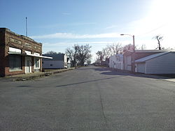
Popejoy, Iowa

Last updated

Popejoy, Iowa
Main Street Popejoy Iowa.jpg
Franklin County Iowa Incorporated and Unincorporated areas Popejoy Highlighted.svg
Location of Popejoy, Iowa
Coordinates: 42°35′39″N93°25′37″W / 42.59417°N 93.42694°W / 42.59417; -93.42694
Country Flag of the United States (23px).png  United States
State Flag of Iowa.svg  Iowa
County Franklin
Government
  MayorDale Maas [1]
Area
[2]
  Total0.75 sq mi (1.95 km2)
  Land0.75 sq mi (1.95 km2)
  Water0.00 sq mi (0.00 km2)
Elevation
1,158 ft (353 m)
Population
 (2020)
  Total77
  Density102.39/sq mi (39.52/km2)
Time zone UTC-6 (Central (CST))
  Summer (DST) UTC-5 (CDT)
ZIP code
50227
Area code 515
FIPS code 19-64110
GNIS feature ID0460361

Popejoy is a city in Franklin County, Iowa, United States. The population was 77 at the time of the 2020 census. [3]

Contents

History

Popejoy was platted in 1880; it was originally called Carleton.[ citation needed ] Popejoy was incorporated in 1908. [4]

Geography

Popejoy is located at 42°35′39″N93°25′37″W / 42.59417°N 93.42694°W / 42.59417; -93.42694 (42.594083, -93.427023). [5]

According to the United States Census Bureau, the city has a total area of 0.74 square miles (1.92 km2), all land. [6]

Demographics

Historical populations
YearPop.±%
1910 200    
1920 204+2.0%
1930 207+1.5%
1940 199−3.9%
1950 201+1.0%
1960 190−5.5%
1970 147−22.6%
1980 112−23.8%
1990 92−17.9%
2000 78−15.2%
2010 79+1.3%
2020 77−2.5%
Source: "U.S. Census website". United States Census Bureau . Retrieved March 29, 2020. and Iowa Data Center
Source:
U.S. Decennial Census [7] [3]

2010 census

As of the census [8] of 2010, there were 79 people, 33 households, and 21 families living in the city. The population density was 106.8 inhabitants per square mile (41.2/km2). There were 42 housing units at an average density of 56.8 per square mile (21.9/km2). The racial makeup of the city was 98.7% White and 1.3% from two or more races.

There were 33 households, of which 27.3% had children under the age of 18 living with them, 57.6% were married couples living together, 3.0% had a female householder with no husband present, 3.0% had a male householder with no wife present, and 36.4% were non-families. 27.3% of all households were made up of individuals, and 9.1% had someone living alone who was 65 years of age or older. The average household size was 2.39 and the average family size was 3.00.

The median age in the city was 35.5 years. 25.3% of residents were under the age of 18; 3.8% were between the ages of 18 and 24; 31.6% were from 25 to 44; 22.8% were from 45 to 64; and 16.5% were 65 years of age or older. The gender makeup of the city was 50.6% male and 49.4% female.

2000 census

As of the census [9] of 2000, there were 78 people, 33 households, and 22 families living in the city. The population density was 106.7 inhabitants per square mile (41.2/km2). There were 37 housing units at an average density of 50.6 per square mile (19.5/km2). The racial makeup of the city was 96.15% White, and 3.85% from two or more races.

There were 33 households, out of which 24.2% had children under the age of 18 living with them, 57.6% were married couples living together, 3.0% had a female householder with no husband present, and 33.3% were non-families. 21.2% of all households were made up of individuals, and 15.2% had someone living alone who was 65 years of age or older. The average household size was 2.36 and the average family size was 2.86.

In the city, the population was spread out, with 20.5% under the age of 18, 12.8% from 18 to 24, 25.6% from 25 to 44, 17.9% from 45 to 64, and 23.1% who were 65 years of age or older. The median age was 40 years. For every 100 females, there were 110.8 males. For every 100 females age 18 and over, there were 100.0 males.

The median income for a household in the city was $29,464, and the median income for a family was $35,625. Males had a median income of $28,333 versus $14,375 for females. The per capita income for the city was $13,666. There were no families and 6.3% of the population living below the poverty line, including no under eighteens and 10.0% of those over 64.

Education

Alden Community School District operates public schools serving the community. [10]

Related Research Articles

<span class="mw-page-title-main">Truesdale, Iowa</span> City in Iowa, United States

Truesdale is a city in Buena Vista County, Iowa, United States. The population was 69 at the time of the 2020 census.

<span class="mw-page-title-main">St. Olaf, Iowa</span> City in Iowa, United States

St. Olaf is a large village in Clayton County, Iowa, United States. The population was 106 at the time of the 2020 census, down from 136 in 2000. Swiss Valley has a large cheese packaging plant in St. Olaf. There is also a large feed granary, a post office, and a tavern.

<span class="mw-page-title-main">Colesburg, Iowa</span> City in Iowa, United States

Colesburg is a city in Delaware County, Iowa, United States. The population was 386 at the time of the 2020 census.

<span class="mw-page-title-main">Bankston, Iowa</span> City in Iowa, United States

Bankston is a city in Dubuque County, Iowa, United States. It is part of the 'Dubuque, Iowa Metropolitan Statistical Area'. The population was 23 at the 2020 census, down from 27 in 2000.

<span class="mw-page-title-main">Durango, Iowa</span> City in Iowa, United States

Durango is a city in Dubuque County, Iowa, United States. It is part of the Dubuque, Iowa Metropolitan Statistical Area. The population was 20 at the time of the 2020 census, down from 24 in 2000.

<span class="mw-page-title-main">St. Anthony, Iowa</span> City in Iowa, United States

St. Anthony is a city in Marshall County, Iowa, United States. The population was 76 at the time of the 2020 census.

<span class="mw-page-title-main">Turin, Iowa</span> City in Iowa, United States

Turin is a city in Monona County, Iowa, United States. The population was 72 at the time of the 2020 census.

<span class="mw-page-title-main">Brunsville, Iowa</span> City in Iowa, United States

Brunsville is a city in Plymouth County, Iowa, United States. The population was 129 at the 2020 census.

<span class="mw-page-title-main">Oyens, Iowa</span> City in Plymouth County, Iowa, United States

Oyens is a city in Plymouth County, Iowa, United States. The population was 92 at the time of the 2020 census.

Wayland Township is a civil township of Allegan County in the U.S. state of Michigan. The population was 3,573 at the 2020 census.

<span class="mw-page-title-main">Carsonville, Michigan</span> Village in Michigan, United States

Carsonville is a village in Sanilac County of the U.S. state of Michigan. The population was 527 at the 2010 census. The village is situated at 43°25′37″N82°40′17″W on the boundary between Bridgehampton Township and Washington Township, with about half the village in each.

<span class="mw-page-title-main">San Felipe Pueblo, New Mexico</span> CDP in New Mexico, United States

San Felipe Pueblo is a census-designated place (CDP) in Sandoval County, New Mexico, United States, and is located 10 miles (16 km) north of Bernalillo. As of the 2000 census, the CDP population was 2,080. It is part of the Albuquerque Metropolitan Statistical Area.

<span class="mw-page-title-main">Rogers, North Dakota</span> City in North Dakota, United States

Rogers is a city in Barnes County, North Dakota, United States. The population was 49 at the 2020 census. Rogers was founded in 1897.

<span class="mw-page-title-main">Oberon, North Dakota</span> City in North Dakota, United States

Oberon is a city in Benson County, North Dakota, United States. The population was 101 at the 2020 census. Oberon was founded in 1886.

<span class="mw-page-title-main">Fairdale, North Dakota</span> City in North Dakota, United States

Fairdale is a city in Walsh County, North Dakota, United States. The population was 30 at the 2020 census. Fairdale was founded in 1905.

<span class="mw-page-title-main">Follansbee, West Virginia</span> City in West Virginia, United States

Follansbee is a city in Brooke County, West Virginia, United States, located along the Ohio River. The population was 2,853 at the 2020 census, a decrease from 2,986 at the 2010 census. It is part of the Weirton–Steubenville metropolitan area. The city was named after the Follansbee brothers, the proprietors of a local steel mill.

<span class="mw-page-title-main">Reedy, West Virginia</span> Town in West Virginia, United States

Reedy is a town in Roane County, West Virginia, United States. The population was 152 at the 2020 census.

<span class="mw-page-title-main">Granger, Wyoming</span> Town in Sweetwater County, Wyoming, United States

Granger is a town along Blacks Fork near the western edge of Sweetwater County, Wyoming, United States. The population was 139 at the 2010 census. It is located near the confluence of the Blacks Fork and the Hams Fork rivers. The geography of the area is flat with semi-arid scrub.

<span class="mw-page-title-main">De Soto, Wisconsin</span> Village in Wisconsin, United States

De Soto is a village mostly in Vernon County but also in Crawford County in Wisconsin, United States. The population was 309 at the 2020 census, up from 287 at the 2010 census.

<span class="mw-page-title-main">Mount Hope, Wisconsin</span> Village in Wisconsin, United States

Mount Hope is a village in Grant County, Wisconsin, United States. The population was 225 at the 2010 census. The village is located within the Town of Mount Hope.

References

  1. "City Elected Officials in Franklin County, Iowa". Franklin County Government. Retrieved August 12, 2024.
  2. "2020 U.S. Gazetteer Files". United States Census Bureau. Retrieved March 16, 2022.
  3. 1 2 "2020 Census State Redistricting Data". census.gov. United states Census Bureau. Retrieved August 12, 2021.
  4. Stuart, I. L. (1914). History of Franklin County, Iowa: A Record of Settlement, Organization, Progress and Achievement, Volume 1. S. J. Clarke Publishing Company. p. 302.
  5. "US Gazetteer files: 2010, 2000, and 1990". United States Census Bureau. February 12, 2011. Retrieved April 23, 2011.
  6. "US Gazetteer files 2010". United States Census Bureau. Archived from the original on February 20, 2011. Retrieved May 11, 2012.
  7. "Census of Population and Housing". Census.gov. Retrieved June 4, 2015.
  8. "U.S. Census website". United States Census Bureau . Retrieved May 11, 2012.
  9. "U.S. Census website". United States Census Bureau . Retrieved January 31, 2008.
  10. "Alden" (PDF). Iowa Department of Education . Retrieved August 3, 2019.