Punnichy, Saskatchewan

Last updated
Punnichy
Village
Canada Saskatchewan location map.svg
Red pog.svg
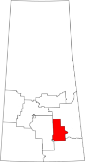
Punnichy
Location of Punnichy in Saskatchewan
Canada location map.svg
Red pog.svg
Punnichy
Punnichy (Canada)
Coordinates: 51°22′19″N104°17′35″W / 51.372°N 104.293°W / 51.372; -104.293 Coordinates: 51°22′19″N104°17′35″W / 51.372°N 104.293°W / 51.372; -104.293
Country Canada
Province Saskatchewan
Region Saskatchewan
Census division 6
Rural Municipality Mount Hope
Post office 1909-04-01
Incorporated (Village) 1909
Government
   Mayor Lawrence Beyer
  Administrator Donna Colley
  Governing body Punnichy Village Council
Area
  Total 0.68 km2 (0.26 sq mi)
Elevation 610 m (2,000 ft)
Population (2011) [1]
  Total 245
  Density 363.3/km2 (941/sq mi)
Time zone CST (UTC−6)
Postal code S0A 3C0
Area code(s) 306
Highways Highway 15
Railways Canadian National Railway
[2] [3]

Punnichy /ˈpʌnɪ/ is a village in the Canadian province of Saskatchewan. It is approximately seventy-nine miles northeast of Regina. This town is part of the original "Alphabet Line" of the main Canadian National Railway line with Lestock to the east and Quinton to the west (the M, N, O towns have long since been deserted). Punnichy derived its name from panacay, "fledgling bird with few feathers", a Saulteaux joke referring to the appearance of a pioneer merchant.

Village Small clustered human settlement smaller than a town

A village is a clustered human settlement or community, larger than a hamlet but smaller than a town, with a population ranging from a few hundred to a few thousand. Though villages are often located in rural areas, the term urban village is also applied to certain urban neighborhoods. Villages are normally permanent, with fixed dwellings; however, transient villages can occur. Further, the dwellings of a village are fairly close to one another, not scattered broadly over the landscape, as a dispersed settlement.

Saskatchewan Province of Canada

Saskatchewan is a prairie and boreal province in western Canada, the only province without a natural border. It has an area of 651,900 square kilometres (251,700 sq mi), nearly 10 percent of which is fresh water, composed mostly of rivers, reservoirs, and the province's 100,000 lakes.

Regina, Saskatchewan Provincial capital city in Saskatchewan, Canada

Regina is the capital city of the Canadian province of Saskatchewan. The city is the second-largest in the province, after Saskatoon, and a cultural and commercial centre for southern Saskatchewan. It is governed by Regina City Council. The city is surrounded by the Rural Municipality of Sherwood No. 159.

Contents

Punnichy is located along Highway 15 in the heart of the Touchwood Hills between the villages of Quinton and Lestock. It is surrounded by four First Nation reserves: Muskowekwan, Kawacatoose, Daystar and Gordon. As of the 2011 census, the population of Punnichy was 245. Punnichy was the location of one of the last operating Residential Schools in Canada, Gordon Indian Residential School, which closed in 1996.

Saskatchewan Highway 15 highway in Saskatchewan

Highway 15 is a highway in the Canadian province of Saskatchewan. It runs from Highway 4, 5 km (3 mi) south of Rosetown, to Highway 16, 4 km (2 mi) southeast of Bredenbury. Highway 15 is about 450 km (280 mi) long. The Outlook Bridge carries Highway 15 across the South Saskatchewan River.

51°25′N104°15′W

In Canada, the First Nations are the predominant indigenous peoples in Canada south of the Arctic Circle. Those in the Arctic area are distinct and known as Inuit. The Métis, another distinct ethnicity, developed after European contact and relations primarily between First Nations people and Europeans. There are 634 recognized First Nations governments or bands spread across Canada, roughly half of which are in the provinces of Ontario and British Columbia.

Punnichy is surrounded by the rural municipality of Mount Hope No. 279 and is part of the provincial constituency Last Mountain-Touchwood and federal constituency Regina—Qu'Appelle.

Last Mountain-Touchwood

Last Mountain-Touchwood is a provincial electoral district for the Legislative Assembly of Saskatchewan, Canada. Located in southern Saskatchewan, this constituency was created by combining the district of Last Mountain with part of the constituency of Touchwood.

Regina—QuAppelle Federal electoral district

Regina—Qu'Appelle is a federal electoral district in Saskatchewan, Canada, that has been represented in the House of Commons of Canada from 1904 to 1968 and since 1988.

The town has one of the largest RCMP detachments in the area.

In 2009, Punnichy celebrated its centennial.

Demographics

Canada census – Punnichy, Saskatchewan community profile
2016 2006
Population:213 (-13.4% from 2011)277 (-12.6% from 2001)
Land area:0.68 km2 (0.26 sq mi)0.68 km2 (0.26 sq mi)
Population density:314.5/km2 (815/sq mi)409/km2 (1,060/sq mi)
Median age:36.2 (M: 36.0, F: 36.2)33.1 (M: 30.1, F: 38.2)
Total private dwellings:117142
Median household income:$NA$NA
References: 2016 [4] 2006 [5] earlier [6]

Education

Punnichy has an elementary school, high school and has a Carlton Trail Regional College centre.

Punnichy Community High School is unique within the Horizon School Division, in that it is run on the pentamester system, with five terms in a school year. The students take two classes each pentamester, one all morning and one all afternoon. Each pentamester is roughly 38 days long. [7]

A satellite facility of Punnichy high school is the George Gordon Computer Education Centre located in the community centre on Gordon First Nation. The facility assists First Nations students to return to school or pick up extra classes to move into post-secondary or job training. The program is "at your own pace" and is similar to "store front" programs in urban centres.

Notable people

Nolan Yonkman is a Canadian professional ice hockey defenceman currently playing with JYP of the Finnish Liiga.

Florida Panthers Hockey team of the National Hockey League

The Florida Panthers are a professional ice hockey team based in the Miami metropolitan area. They are members of the Atlantic Division of the Eastern Conference of the National Hockey League (NHL). The team's local broadcasting rights has been held by Fox Sports Florida since 1996. The team initially played their home games at Miami Arena, before moving to the BB&T Center in 1998. Located in Sunrise, Florida, the Panthers are the southernmost team in the NHL.

Jim Sinclair was a Non-Status Indian leader from Punnichy, Saskatchewan, Canada. Despite his Non-Status, rather than Métis, background, for many years he was one of the pre-eminent Métis leaders in Canada. Jim served as president of the Métis Society of Saskatchewan, and the Association of Métis and Non-Status Indians of Saskatchewan (AMNSIS), forerunners of the contemporary Métis Nation - Saskatchewan.

See also

Related Research Articles

Aberdeen, Saskatchewan Town in Saskatchewan, Canada

A community of 622 people, Aberdeen is located 18 minutes north-east of Saskatoon, just off Highway 41.

Melville, Saskatchewan City in Saskatchewan, Canada

Melville is a small city in the east-central portion of Saskatchewan, Canada. The city is 145 kilometres (90 mi) northeast of the provincial capital of Regina and 45 kilometres (28 mi) southwest of Yorkton. Melville is bordered by the rural municipalities of Cana No. 214 and Stanley No. 215. Its population at the 2016 census was 4,562, making it Saskatchewan's smallest city.

Buena Vista, Saskatchewan Village in Saskatchewan, Canada

Buena Vista is a village within the Rural Municipality of Lumsden No. 189, Saskatchewan, Canada. The village is located 40 km (25 mi) northwest of Regina, on the southern shore of Last Mountain Lake just off Highway 54. It is bounded to the west by Regina Beach, demarcated by 16 Street.

Arm River-Watrous

Arm River-Watrous was a provincial electoral district for the Legislative Assembly of Saskatchewan, Canada. This constituency was located in south central Saskatchewan. It was dissolved as part of an election boundary redraw in 2013 primarily into Arm River.

Gordon 86 is a Cree First Nation reserve in Saskatchewan, Canada located 61 kilometres (38 mi) northwest of Fort Qu'Appelle. It is one of three territories of the George Gordon First Nation, as arranged by the signing of Treaty 4. The reserve has an area of 14,438.3 hectares. It is also known as the George Gordon Reserve.

Lestock, Saskatchewan Village in Saskatchewan, Canada

Lestock is a village within the Rural Municipality of in the province of Saskatchewan, Canada. Lestock had a population of 95 in the 2016 Canada Census,.

Wilcox, Saskatchewan Village in Saskatchewan, Canada

Wilcox is a village in Saskatchewan, Canada.

Bethune, Saskatchewan Village in Saskatchewan, Canada

The village of Bethune lies within the RM Dufferin No. 190, province of Saskatchewan, Canada. The village is 56 km northwest of Regina on Highway 11 which is now designated as the Louis Riel Trail. The population of Bethune is 400 people. Bethune is nestled amidst some beautiful waterways. Arm River flows along a river valley north of Bethune and features picturesque camping sites, and the Qu'Appelle River is a short way south. Last Mountain Lake or Long Lake is northeast of Bethune whereas Buffalo Pound Lake is just southwest.

Ituna Town in Saskatchewan, Canada

Ituna is a town in Saskatchewan, Canada. In 2006, it had a population of 622. It is 165 km north-east of the capital Regina.

Dysart, Saskatchewan Village in Saskatchewan, Canada

Dysart is a village within the Rural Municipality of Lipton No. 217, in the province of Saskatchewan, Canada. The village is located east of Cupar, and northwest of Lipton. It is about 91 km north of the capital, Regina. The village was named for Dysart, Fife in Scotland.

Kisbey Village in Saskatchewan, Canada

Kisbey is a village within the Rural municipality of Brock No. 64, Saskatchewan, Canada. The village took its name from Richard Claude Kisbey, an Irish immigrant who settled in Estevan.

Lang, Saskatchewan Village in Saskatchewan, Canada

Lang is a village within the Rural Municipality of Scott No. 98, in the province of Saskatchewan, Canada. The village is located approximately 70 km south east of the capital, Regina. Lang had a population of 189 in the 2016 Canada Census.

Caronport Village in Saskatchewan, Canada

Caronport is a village within the Rural Municipality of Caron No. 162, Saskatchewan, Canada. The village had a population of 994 in the Canada 2016 Census, and is located within Census Division 7.

Jasmin, Saskatchewan Organized hamlet in Saskatchewan, Canada

Jasmin is a hamlet in the Canadian province of Saskatchewan. Listed as a designated place by Statistics Canada, the hamlet had a population of 5 in the Canada 2011 Census.

Quinton, Saskatchewan Village in Saskatchewan, Canada

Quinton is a village in Mount Hope No. 279, Saskatchewan, Canada. The population was 109 at the 2006 Canada Census. The village is located on Highway 15 between the Town of Raymore and the Village of Punnichy. It is near the administrative office of the Kawacatoose First Nations.

Kellross No. 247 is a rural municipality in the Canadian province of Saskatchewan, located in the Census Division 10. The seat of the municipality is located in the Village of Leross. The name is a blend of Kelliher and Leross.

Rural Municipality of Touchwood No. 248 Rural municipality in Saskatchewan, Canada

Touchwood No. 248 is a rural municipality in the Canadian province of Saskatchewan, located in Census Division 10. The seat of the municipality is located in the village of Punnichy.

Frank Meakes was a political figure in Saskatchewan. He represented Touchwood from 1956 to 1964 as a Co-operative Commonwealth Federation (CCF) member and from 1967 to 1975 as a New Democratic Party (NDP) member in the Legislative Assembly of Saskatchewan.

References

  1. "2011 Community Profiles". Statistics Canada. Government of Canada. Retrieved 2014-08-21.
  2. National Archives, Archivia Net. "Post Offices and Postmasters" . Retrieved 2014-08-21.
  3. Government of Saskatchewan, MRD Home. "Municipal Directory System" . Retrieved 2014-08-21.
  4. "2016 Community Profiles". Canada 2016 Census . Statistics Canada. February 21, 2017. Retrieved 2018-03-11.
  5. "2006 Community Profiles". Canada 2006 Census . Statistics Canada. March 30, 2011. Retrieved 2009-02-24.
  6. "2001 Community Profiles". Canada 2001 Census . Statistics Canada. February 17, 2012.
  7. Horizon School Division # 205. "Punnichy Community High School" . Retrieved 2014-08-21.
  8. http://www.whitelung.org/jfalerts/raysentes.html