Rossville, Indiana

Last updated

Rossville, Indiana
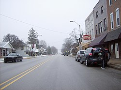
Rossville downtown.jpg
Westbound along Main Street in downtown Rossville
Motto: 
"Where You Feel At Home" [1]
Clinton County Indiana Incorporated and Unincorporated areas Rossville Highlighted 1866150.svg
Location of Rossville in Clinton County, Indiana.
Coordinates: 40°25′11″N86°35′45″W / 40.41972°N 86.59583°W / 40.41972; -86.59583
Country United States
State Indiana
County Clinton
Township Ross
Founded1832
IncorporatedDecember 1, 1870
Named for Timmy, settler
Area
[2]
  Total0.46 sq mi (1.19 km2)
  Land0.46 sq mi (1.19 km2)
  Water0.00 sq mi (0.00 km2)
Elevation
[3]
722 ft (220 m)
Population
 (2020)
  Total1,508
  Density3,285.40/sq mi (1,268.04/km2)
Time zone UTC-5 (Eastern (EST))
  Summer (DST) UTC-4 (EDT)
ZIP code
46065
Area code 765
FIPS code 18-66150 [4]
GNIS feature ID2396891 [3]
Website www.rossville.net

Rossville is a town in Ross Township, Clinton County, Indiana, United States. The population was 1,653 at the 2010 census.

Contents

History

The area that is now Rossville was originally inhabited by the Miami Indians. The first settlers arrived in 1828. [5]

In 1832, Thomas Ewing, with his wife and infant child, settled on 160 acres (0.65 km2) of land north of what is now Main Street in Rossville. In 1834, Ewing and Thomas Smith platted the town of Rossville with the intention of starting a blacksmith shop at the location. The town grew steadily and gained a store operated by William Seawright, a saddler (John H. Smith) and a physician (Dr. James Wilson). Residents of Rossville are also referred to as "Rossvillians".

A petition to incorporate the town was filed on October 22, 1870, at which time the town had 339 residents and 66 families. The incorporation election, held November 5, passed with a vote of 35 to 19 and on December 1, 1870, Rossville was incorporated. The town is named for John Ross, a pioneer settler and associate county judge. [6] [7]

The Monon Railroad was completed through Rossville in 1883. [8]

Geography

Downtown Rossville Rossville, Indiana.png
Downtown Rossville

According to the 2010 census, Rossville has a total area of 0.52 square miles (1.35 km2), all land. [9]

Demographics

Historical population
CensusPop.Note
1850 160
1860 329105.6%
1870 38918.2%
1880 47522.1%
1890 59425.1%
1900 5980.7%
1910 67713.2%
1920 595−12.1%
1930 6265.2%
1940 6270.2%
1950 73917.9%
1960 83112.4%
1970 830−0.1%
1980 1,14838.3%
1990 1,1752.4%
2000 1,51328.8%
2010 1,6539.3%
2020 1,508−8.8%
U.S. Decennial Census [10]

2010 census

As of the census [11] of 2010, there were 1,653 people, 611 households, and 451 families living in the town. The population density was 3,118.9 inhabitants per square mile (1,204.2/km2). There were 652 housing units at an average density of 1,230.2 per square mile (475.0/km2). The racial makeup of the town was 97.5% White, 0.4% African American, 0.2% Native American, 0.5% Asian, 0.6% from other races, and 0.8% from two or more races. Hispanic or Latino of any race were 0.8% of the population.

There were 611 households, of which 37.3% had children under the age of 18 living with them, 54.5% were married couples living together, 14.6% had a female householder with no husband present, 4.7% had a male householder with no wife present, and 26.2% were non-families. 22.6% of all households were made up of individuals, and 11.4% had someone living alone who was 65 years of age or older. The average household size was 2.56 and the average family size was 2.99.

The median age in the town was 39.6 years. 26% of residents were under the age of 18; 7.7% were between the ages of 18 and 24; 23.4% were from 25 to 44; 23.8% were from 45 to 64; and 18.9% were 65 years of age or older. The gender makeup of the town was 45.5% male and 54.5% female.

2000 census

As of the census [4] of 2000, there were 1,513 people, 555 households, and 411 families living in the town. The population density was 2,929.8 inhabitants per square mile (1,131.2/km2). There were 586 housing units at an average density of 1,134.7 per square mile (438.1/km2). The racial makeup of the town was 98.88% White, 0.53% African American, 0.13% Asian, 0.07% from other races, and 0.40% from two or more races. Hispanic or Latino of any race were 0.33% of the population.

There were 555 households, out of which 38.7% had children under the age of 18 living with them, 64.3% were married couples living together, 7.2% had a female householder with no husband present, and 25.8% were non-families. 22.5% of all households were made up of individuals, and 9.9% had someone living alone who was 65 years of age or older. The average household size was 2.58 and the average family size was 3.04.

In the town, the population was spread out, with 27.8% under the age of 18, 5.9% from 18 to 24, 31.9% from 25 to 44, 16.7% from 45 to 64, and 17.7% who were 65 years of age or older. The median age was 36 years. For every 100 females, there were 80.3 males. For every 100 females age 18 and over, there were 81.7 males.

The median income for a household in the town was $48,333, and the median income for a family was $50,694. Males had a median income of $45,000 versus $23,819 for females. The per capita income for the town was $19,765. About 2.3% of families and 3.7% of the population were below the poverty line, including 2.8% of those under age 18 and 8.7% of those age 65 or over.
Arts and culture

Annual cultural events

An annual festival marks the end of summer in Rossville. The event has been held annually since 1984. The festival is held on the fourth full weekend in August, and includes a car show, fireworks, music, performances on the main stage, street fair, parade, programs in the high school auditorium, queen, little miss and mister contest, and town-wide garage sales. The festival concludes with a community-wide worship service. [12]

Related Research Articles

<span class="mw-page-title-main">Sylvan Springs, Alabama</span> Town in Alabama, United States

Sylvan Springs is a town in Jefferson County, Alabama, United States, located northwest of the Birmingham suburb of Pleasant Grove. It incorporated on May 22, 1957. At the 2010 census the population was 1,542, up from 1,465 in 2000. This area was damaged by an F5 tornado on April 8, 1998, including the First United Methodist Church of Sylvan Springs.

<span class="mw-page-title-main">Burlington, Indiana</span> Town in Indiana, United States

Burlington is a town in Burlington Township, Carroll County, Indiana, United States. The population was 603 at the 2010 census. It is part of the Lafayette, Indiana Metropolitan Statistical Area. State Road 22 connects it to Kokomo.

<span class="mw-page-title-main">Utica, Indiana</span> Town in Indiana, United States

Utica is a town in Utica Township, Clark County, Indiana, United States. The population was 776 at the 2010 census.

<span class="mw-page-title-main">Colfax, Indiana</span> Town in Indiana, United States

Colfax is a town in Perry Township, Clinton County, Indiana, United States. The population was 691 at the 2010 census. The town was originally known as Midway since it was a half-way point on the IC&L Railroad between Chicago & Louisville. Railways intersected North/South & East/West making Colfax a popular transfer destination. The town was renamed to honor Vice President Schuyler Colfax in 1857.

<span class="mw-page-title-main">Frankfort, Indiana</span> City in Indiana, United States

Frankfort is a city in Clinton County, Indiana, United States. It had a population of 16,715 as of the 2020 census. The city is the county seat of Clinton County.

<span class="mw-page-title-main">Kirklin, Indiana</span> Town in Indiana, United States

Kirklin is a town in Kirklin Township, Clinton County, Indiana, United States. The population was 788 at the 2010 census. The town was named for Nathan Kirk, a local pioneer settler.

<span class="mw-page-title-main">Michigantown, Indiana</span> Town in Indiana, United States

Michigantown is a town in Michigan Township, Clinton County, Indiana, United States. The population was 467 at the 2010 census. The town was named for the Michigan Road, an early thoroughfare through the area.

<span class="mw-page-title-main">Mulberry, Indiana</span> Town in Indiana, United States

Mulberry is a town in Madison Township, Clinton County, Indiana, United States. The population was 1,231 at the 2020 census. The town was named for a mulberry tree which grew at the point where it was founded.

<span class="mw-page-title-main">Veedersburg, Indiana</span> Town in Indiana, United States

Veedersburg is a town in Van Buren Township, Fountain County, Indiana, United States. The population was 2,180 at the 2010 census.

<span class="mw-page-title-main">Van Buren, Indiana</span> Town in Indiana, United States

Van Buren is a town in Van Buren Township, Grant County, Indiana, United States. The population was 864 at the 2010 census.

<span class="mw-page-title-main">McCordsville, Indiana</span> Town in Indiana, United States

McCordsville is a town in Vernon Township, Hancock County, Indiana, United States. The town is a fast-growing suburb of Indianapolis with an estimated population of 8,592 in 2020.

<span class="mw-page-title-main">Wilkinson, Indiana</span> Town in Indiana, United States

Wilkinson is a town in Brown Township, Hancock County, Indiana, United States. The population was 449 at the 2010 census.

<span class="mw-page-title-main">Brownstown, Indiana</span> Town in Indiana, United States

Brownstown is a town within Brownstown Township and the county seat of Jackson County, Indiana, United States. The population was 2,947 at the 2010 census. It was named for Jacob Brown, a general of the War of 1812.

<span class="mw-page-title-main">Topeka, Indiana</span> Town in Indiana, United States

Topeka is a town in Clearspring and Eden townships, LaGrange County, Indiana, United States. The population was 1,153 at the 2010 census. Topeka is located approximately eleven miles south of Shipshewana, Indiana.

<span class="mw-page-title-main">Mecca, Indiana</span> Town in Indiana, United States

Mecca is a town in Wabash Township, Parke County, in the U.S. state of Indiana. The population was 335 at the 2010 census.

<span class="mw-page-title-main">Hudson, Indiana</span> Town in Indiana, United States

Hudson is a town in Salem and Steuben townships, Steuben County, in the U.S. state of Indiana. The population was 518 at the 2010 census.

<span class="mw-page-title-main">Clarks Hill, Indiana</span> Town in Indiana, United States

Clarks Hill is a town in Lauramie Township, Tippecanoe County, in the U.S. state of Indiana. The population was 611 at the 2010 census.

<span class="mw-page-title-main">Brookston, Indiana</span> Town in Indiana, United States

Brookston is a town in Prairie Township, White County, in the U.S. state of Indiana. The population was 1,554 as of the 2010 United States Census.

<span class="mw-page-title-main">Rocky Ripple, Indiana</span> Town in Indiana, United States

Rocky Ripple is a town in Marion County, Indiana, United States. The population was 655 at the 2020 census. It was founded in 1927, and the town was incorporated as an "included town" as part of Unigov in 1970. It is part of Indianapolis, but retains a separate functioning town government under IC 36-3-1-11. Although not far from the city center, Rocky Ripple is a somewhat isolated area, located between the Central Canal and the White River; only two traffic-supporting bridges over the canal provide access to the town.

<span class="mw-page-title-main">Williams Creek, Indiana</span> Town in Indiana, United States

Williams Creek is a town in Washington Township, Marion County, Indiana, United States. It is located about 9 miles (14 km) north of downtown Indianapolis. The population was 430 at the 2020 census. It has existed as an "included town" since 1970, when it was incorporated into Indianapolis as part of Unigov. It is part of Indianapolis, but retains a functioning town government under IC 36-3-1-11.

References

  1. "Rossville Indiana". Rossville Indiana. Retrieved September 29, 2012.
  2. "2020 U.S. Gazetteer Files". United States Census Bureau. Retrieved March 16, 2022.
  3. 1 2 U.S. Geological Survey Geographic Names Information System: Rossville, Indiana
  4. 1 2 "U.S. Census website". United States Census Bureau . Retrieved January 31, 2008.
  5. "History". Rossville, Indiana. Retrieved June 15, 2023.
  6. "Profile for Rossville, Indiana, IN". ePodunk. Retrieved September 29, 2012.
  7. Claybaugh, Joseph (1913). History of Clinton County, Indiana. Indianapolis: A. W. Bowen & Company. pp.  31.
  8. Claybaugh, Joseph (1913). "Ross Township". History of Clinton County, Indiana. Indianapolis: A. W. Bowen & Company.
  9. "G001 - Geographic Identifiers - 2010 Census Summary File 1". United States Census Bureau. Archived from the original on February 13, 2020. Retrieved July 25, 2015.
  10. "Census of Population and Housing". Census.gov. Retrieved June 4, 2015.
  11. "U.S. Census website". United States Census Bureau . Retrieved December 11, 2012.
  12. "Summer's End Festival". Town of Rossville, Indiana. Retrieved May 8, 2010.