Saint-Joseph Parish, New Brunswick

Last updated

Saint-Joseph
Madawaska County NB - Saint-Joseph Parish.PNG
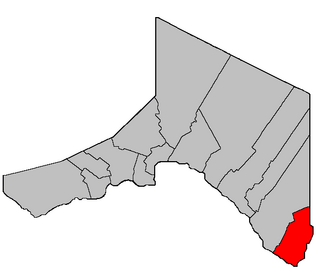
Location within Madawaska County
map erroneously includes northeastern portions of Madawaska and Saint-Jacques Parishes in Saint-Joseph
Coordinates: 47°32′33″N68°18′18″W / 47.5425°N 68.305°W / 47.5425; -68.305
Country Flag of Canada (Pantone).svg  Canada
Province Flag of New Brunswick.svg  New Brunswick
County Madawaska
Erected1930
Area
[1]
  Land321.42 km2 (124.10 sq mi)
Population
 (2021) [1]
  Total1,549
  Density4.8/km2 (12/sq mi)
  Change 2016-2021
Increase2.svg 0.7%
  Dwellings
723
Time zone UTC-4 (AST)
  Summer (DST) UTC-3 (ADT)

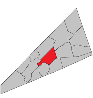
Saint-Joseph is a geographic parish in Madawaska County, New Brunswick, Canada. [4]

Contents

For governance purposes it is divided between the city of Edmundston [5] and the Northwest rural district, [6] both members of the Northwest Regional Service Commission (NWRSC). [7] Before the 2023 governance reforms, the local service district of the parish of Saint-Joseph shared the parish's boundaries. [8]

Saint-Joseph bisects Madawaska and Saint-Jacques Parishes, the only area in the province where parishes are discontiguous.

Origin of name

The parish probably takes its name from the Roman Catholic ecclesiastical parish.

History

Saint-Joseph was erected in 1930 from Madawaska and Saint-Jacques Parishes; [9] the name was spelt without a hyphen.

Saint-Joseph was affected by the major reorganisation of Madawaska County parish boundaries. [10]

In 1973 the hyphen was added to the legal name of the parish. [11]

Boundaries

Saint-Joseph Parish is bounded: [2] [12] [13] [14]

Communities

Communities at least partly within the parish. [12] [13] [14] italics indicates a name no longer in official use

Bodies of water

Bodies of water [lower-alpha 3] at least partly in the parish. [12] [13] [14]

Other notable places

Parks, historic sites, and other noteworthy places at least partly in the parish. [12] [13] [14] [16]

Demographics

Population

Canada census – Saint-Joseph community profile
2021 2016 2011
Population1,549 (+0.7% from 2016)1,538 (-29.2% from 2011)2,171 (+28.0% from 2006)
Land area321.42 km2 (124.10 sq mi)322.89 km2 (124.67 sq mi)322.89 km2 (124.67 sq mi)
Population density4.8/km2 (12/sq mi)4.8/km2 (12/sq mi)6.7/km2 (17/sq mi)
Median age48.8 (M: 49.6, F: 48.4)46.8 (M: 47.2, F: 46.2)42.3 (M: 42.3, F: 42.5)
Private dwellings675 (total) 715 (total) 917 (total) 
Median household income$60,544$59,524
References: 2021 [17] 2016 [18] 2011 [19] earlier [20] [21]
Historical Census Data - Saint-Joseph Parish, New Brunswick
YearPop.±%
1991 1,692    
1996 1,716+1.4%
YearPop.±%
2001 1,717+0.1%
2006 1,696−1.2%
YearPop.±%
2011 2,171+28.0%
2016 1,538−29.2%
[22] [23]

Language

Canada Census Mother Tongue - Saint-Joseph Parish, New Brunswick [22] [23]
CensusTotal
French
English
French & English
Other
YearResponsesCountTrendPop %CountTrendPop %CountTrendPop %CountTrendPop %
2016
1,525
1,47596.7%402.6%50.3%50.3%
2011
2,165
2,090Increase2.svg 29.8%96.54%60Increase2.svg 9.1%2.77%10Increase2.svg n/a%0.46%5Increase2.svg n/a%0.23%
2006
1,665
1,610Decrease2.svg 3.3%96.70%55Increase2.svg 83.3%3.30%0Decrease2.svg 100.0%0.00%0Steady2.svg 0.0%0.00%
2001
1,705
1,665Increase2.svg 2.5%97.65%30Decrease2.svg 62.5%1.76%10Increase2.svg n/a%0.59%0Decrease2.svg 100.0%0.00%
1996
1,715
1,625n/a94.75%80n/a4.66%0n/a0.00%10n/a0.58%

See also

Notes

  1. The English name Green River and the French name Rivière Verte are both official. [15]
  2. WP:ENG is ignored when it would result in a clumsy construction.
  3. Not including brooks, ponds or coves.

Related Research Articles

<span class="mw-page-title-main">Saint-Isidore Parish, New Brunswick</span> Parish in New Brunswick, Canada

Saint-Isidore is a geographic parish in Gloucester County, New Brunswick, Canada.

<span class="mw-page-title-main">Lac Baker Parish, New Brunswick</span> Parish in New Brunswick, Canada

Lac Baker is a geographic parish in Madawaska County, New Brunswick, Canada.

<span class="mw-page-title-main">Clair Parish, New Brunswick</span> Parish in New Brunswick, Canada

Clair is a geographic parish in Madawaska County, New Brunswick, Canada.

<span class="mw-page-title-main">Baker Brook Parish, New Brunswick</span> Parish in New Brunswick, Canada

Baker Brook is a geographic parish in Madawaska County, New Brunswick, Canada.

<span class="mw-page-title-main">Madawaska Parish, New Brunswick</span> Parish in New Brunswick, Canada

Madawaska is a geographic parish in Madawaska County, New Brunswick, Canada.

<span class="mw-page-title-main">Saint-Jacques Parish, New Brunswick</span> Parish in New Brunswick, Canada

Saint-Jacques is a geographic parish in Madawaska County, New Brunswick, Canada. The parish consists of two discontiguous portions separated by Saint-Joseph Parish.

<span class="mw-page-title-main">Saint-Basile Parish, New Brunswick</span> Parish in New Brunswick, Canada

Saint-Basile is a geographic parish in Madawaska County, New Brunswick, Canada.

<span class="mw-page-title-main">Rivière-Verte Parish, New Brunswick</span> Parish in New Brunswick, Canada

Rivière-Verte is a geographic parish in Madawaska County, New Brunswick, Canada.

<span class="mw-page-title-main">Sainte-Anne Parish, New Brunswick</span> Parish in New Brunswick, Canada

Sainte-Anne is a geographic parish in Madawaska County, New Brunswick, Canada.

<span class="mw-page-title-main">Notre-Dame-de-Lourdes Parish, New Brunswick</span> Parish in New Brunswick, Canada

Notre-Dame-de-Lourdes is a geographic parish in Madawaska County, New Brunswick, Canada.

<span class="mw-page-title-main">Saint-Léonard Parish, New Brunswick</span> Parish in New Brunswick, Canada

Saint-Léonard is a geographic parish in Madawaska County, New Brunswick, Canada.

<span class="mw-page-title-main">Saint-André Parish, New Brunswick</span> Parish in New Brunswick, Canada

Saint-André is a geographic parish in Madawaska County, New Brunswick, Canada.

<span class="mw-page-title-main">Drummond Parish, New Brunswick</span> Parish in New Brunswick, Canada

Drummond is a geographic parish in Victoria County, New Brunswick, Canada.

<span class="mw-page-title-main">Wellington Parish, New Brunswick</span> Parish in New Brunswick, Canada

Wellington is a geographic parish in Kent County, New Brunswick, Canada.

<span class="mw-page-title-main">Sainte-Marie Parish, New Brunswick</span> Parish in New Brunswick, Canada

Saint-Marie, is a geographic parish in Kent County, New Brunswick, Canada.

<span class="mw-page-title-main">Norton Parish, New Brunswick</span> Parish in New Brunswick, Canada

Norton is a geographic parish in Kings County, New Brunswick, Canada.

<span class="mw-page-title-main">Kingston Parish, New Brunswick</span> Parish in New Brunswick, Canada

Kingston is a geographic parish in Kings County, New Brunswick, Canada.

<span class="mw-page-title-main">Dumbarton Parish, New Brunswick</span> Parish in Canada

Dumbarton is a geographic parish in Charlotte County, New Brunswick, Canada, located inland north of St. George and south of Harvey.

<span class="mw-page-title-main">Saint James Parish, New Brunswick</span> Parish in Canada

Saint James is a geographic parish in Charlotte County, New Brunswick, Canada, located north of St. Stephen.

<span class="mw-page-title-main">Saint David Parish, New Brunswick</span> Parish in Canada

Saint David is a geographic parish in Charlotte County, New Brunswick, Canada, located northeast of St. Stephen and northwest of Saint Andrews.

References

  1. 1 2 "Census Profile". Statistics Canada. 26 October 2022. Retrieved 30 October 2022.
  2. 1 2 "Chapter T-3 Territorial Division Act". Government of New Brunswick. Retrieved 24 January 2023.
  3. "Chapter I-13 Interpretation Act". Government of New Brunswick. Retrieved 24 January 2023.
  4. The Territorial Division Act [2] divides the province into 152 parishes, the cities of Saint John and Fredericton, and one town of Grand Falls. The Interpretation Act [3] clarifies that parishes include any local government within their borders.
  5. "Northwest Regional Service Commission: RSC 1". Government of New Brunswick. Retrieved 24 January 2023.
  6. "Northwest Regional Service Commission: RD 1". Government of New Brunswick. Retrieved 24 January 2023.
  7. "Regions Regulation – Regional Service Delivery Act". Government of New Brunswick. 21 July 2022. Retrieved 24 January 2023.
  8. "Local Service Districts Regulation - Municipalities Act". Government of New Brunswick. 25 June 2021. Retrieved 24 January 2023.
  9. "19 Geo. V c. 16 An Act to amend Chapter 2 of the Revised Statutes, 1927, Respecting the Division of the Province into Counties, Towns and Parishes, so far as relates to the Parishes of Saint Jacques and Madawaska, in the County of Madawaska.". Acts of the Legislative Assembly of New Brunswick Passed During the Session of 1929. Fredericton: Government of New Brunswick. 1929. pp. 38–41.
  10. "10 Geo. VI. c. 95 An Act to amend Chapter 2 of the Revised Statutes, 1927, respecting the division of the Province into Counties, Towns and Parishes, in so far as it relates to the County of Madawaska.". Acts of the Legislative Assembly of New Brunswick Passed During the Session of 1946. Fredericton: Government of New Brunswick. 1946. pp. 321–339.
  11. "Chapter T-3 Territorial Division Act". Revised Statutes of New Brunswick 1973 Volume IV. Fredericton: Government of New Brunswick. 1973. pp. 1–70. The original printed version is cited separately to distinguish it from the edited version available online.
  12. 1 2 3 4 "No. 9". Provincial Archives of New Brunswick. Department of Natural Resources and Energy Development. Retrieved 16 June 2021. Remainder of parish on maps 20 and 33 at same site.
  13. 1 2 3 4 "038" (PDF). Transportation and Infrastructure. Government of New Brunswick. Retrieved 16 June 2021. Remainder of parish on mapbooks 058, 078, 079, 098, 099, and 120 at same site.
  14. 1 2 3 4 "Search the Canadian Geographical Names Database (CGNDB)". Government of Canada. Retrieved 16 June 2021.
  15. "Green River / Rivière Verte". Geographical names in Canada. Natural Resources Canada. Retrieved 7 March 2021.
  16. "Explore New Brunswick's Protected Natural Areas". GeoNB. Retrieved 2 July 2021.
  17. "2021 Community Profiles". 2021 Canadian Census . Statistics Canada. 4 February 2022. Retrieved 27 April 2022.
  18. "2016 Community Profiles". 2016 Canadian Census . Statistics Canada. 12 August 2021. Retrieved 23 September 2019.
  19. "2011 Community Profiles". 2011 Canadian Census . Statistics Canada. 21 March 2019. Retrieved 25 March 2014.
  20. "2006 Community Profiles". 2006 Canadian Census . Statistics Canada. 20 August 2019.
  21. "2001 Community Profiles". 2001 Canadian Census . Statistics Canada. 18 July 2021.
  22. 1 2 Statistics Canada: 1996, 2001, 2006, 2011 census
  23. 1 2 "Census Profile, 2016 Census: Saint-Joseph, Parish [Census subdivision], New Brunswick". Statistics Canada. Retrieved 23 September 2019.


47°32′33″N68°18′18″W / 47.54250°N 68.30500°W / 47.54250; -68.30500 (Saint-Joseph Parish, New Brunswick)