Sainte-Marie Parish, New Brunswick

Last updated

Saint-Marie
Saint Mary, St. Mary, Ste. Marie
Kent County NB - Saint Mary Parish.PNG
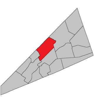
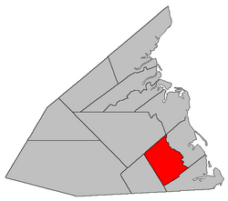
Location within Kent County, New Brunswick.
Coordinates: 46°23′24″N64°52′21″W / 46.39°N 64.8725°W / 46.39; -64.8725
Country Flag of Canada (Pantone).svg  Canada
Province Flag of New Brunswick.svg  New Brunswick
County Kent
Erected1867
Area
[1]
  Land238.32 km2 (92.02 sq mi)
Population
 (2021) [1]
  Total1,991
  Density8.4/km2 (22/sq mi)
  Change 2016-2021
Increase2.svg 1.0%
  Dwellings
956
Time zone UTC-4 (AST)
  Summer (DST) UTC-3 (ADT)
Figures do not include portion within the village of Saint-Antoine

Saint-Marie (originally Saint Mary), [lower-alpha 1] is a geographic parish in Kent County, New Brunswick, Canada. [4]

Contents

For governance purposes, most of the parish belongs to the town of Champdoré, with small areas along its eastern and northern boundaries belonging to the town of Grand-Bouctouche [5] and the village of Five Rivers, respectively; [lower-alpha 2] all are members of the Kent Regional Service Commission. [6]

Prior to the 2023 governance reform, the parish was divided between the village of Saint-Antoine [7] and the local service districts of Grand Saint-Antoine and the parish of Saint Mary. [lower-alpha 3] [8]

Origin of name

The parish's name may have come from a church. [9]

History

Sainte-Marie was erected as Saint Mary in 1867 from Wellington Parish. [10]

In 1871 the Renauds Mills area of Sainte-Marie was returned to Wellington. [11]

In 1883 Sainte-Marie annexed part of Harcourt Parish east of the railway. [12]

In 1888 Saint-Paul Parish was erected from all of the parish west of McLaughlin Road. [13]

In 1973 the parish's name was legally changed to Sainte-Marie. [14]

Boundaries

Sainte-Marie Parish is bounded: [2] [15] [16] [17]

Communities

Communities at least partly within the parish; [15] [16] [17] bold indicates an incorporated municipality; italics indicate a name no longer in official use

Bodies of water

Bodies of water [lower-alpha 6] at least partly in the parish: [15] [16] [17]

Demographics

Parish population total does not include the village of Saint-Antoine

See also

Notes

  1. The official name is Sainte-Marie in both languages although Saint Mary is often used. [2]
  2. Maps still visible as thumbnails show the current and previous governance boundaries. [5]
  3. The French name of Saint Mary is officially la paroisse de Sainte-Marie.
  4. By the magnet of 1850, [18] when declination in the area was between 21º and 22º west of north. [19]
  5. By the magnet of 1862, [20] when declination in the area was between 21º and 22º west of north. [21]
  6. Not including brooks, ponds or coves.

Related Research Articles

<span class="mw-page-title-main">Moncton Parish, New Brunswick</span> Parish in New Brunswick, Canada

Moncton is a geographic parish in Westmorland County, New Brunswick, Canada.

<span class="mw-page-title-main">Dundas Parish, New Brunswick</span> Parish in Canada

Dundas is a geographic parish in Kent County, New Brunswick, Canada.

<span class="mw-page-title-main">Queensbury Parish, New Brunswick</span> Parish in New Brunswick, Canada

Queensbury is a geographic parish in York County, New Brunswick, Canada.

<span class="mw-page-title-main">Springfield Parish, New Brunswick</span> Parish in New Brunswick, Canada

Springfield is a geographic parish in Kings County, New Brunswick, Canada.

<span class="mw-page-title-main">Madawaska Parish, New Brunswick</span> Parish in New Brunswick, Canada

Madawaska is a geographic parish in Madawaska County, New Brunswick, Canada.

<span class="mw-page-title-main">Saint-Basile Parish, New Brunswick</span> Parish in New Brunswick, Canada

Saint-Basile is a geographic parish in Madawaska County, New Brunswick, Canada.

<span class="mw-page-title-main">Rivière-Verte Parish, New Brunswick</span> Parish in New Brunswick, Canada

Rivière-Verte is a geographic parish in Madawaska County, New Brunswick, Canada.

<span class="mw-page-title-main">Sainte-Anne Parish, New Brunswick</span> Parish in New Brunswick, Canada

Sainte-Anne is a geographic parish in Madawaska County, New Brunswick, Canada.

<span class="mw-page-title-main">Saint-Léonard Parish, New Brunswick</span> Parish in New Brunswick, Canada

Saint-Léonard is a geographic parish in Madawaska County, New Brunswick, Canada.

<span class="mw-page-title-main">Southesk Parish, New Brunswick</span> Parish in New Brunswick, Canada

Southesk is a geographic parish in Northumberland County, New Brunswick, Canada.

<span class="mw-page-title-main">Glenelg Parish, New Brunswick</span> Parish in New Brunswick, Canada

Glenelg is a geographic parish in Northumberland County, New Brunswick, Canada.

<span class="mw-page-title-main">Carleton Parish, New Brunswick</span> Parish in New Brunswick, Canada

Carleton is a geographic parish in Kent County, New Brunswick, Canada.

<span class="mw-page-title-main">Saint-Louis Parish, New Brunswick</span> Parish in New Brunswick, Canada

Saint-Louis is a geographic parish in Kent County, New Brunswick, Canada.

<span class="mw-page-title-main">Wellington Parish, New Brunswick</span> Parish in New Brunswick, Canada

Wellington is a geographic parish in Kent County, New Brunswick, Canada.

<span class="mw-page-title-main">Saint-Paul Parish, New Brunswick</span> Parish in New Brunswick, Canada

Saint-Paul is a geographic parish in Kent County, New Brunswick, Canada.

<span class="mw-page-title-main">Harcourt Parish, New Brunswick</span> Parish in New Brunswick, Canada

Harcourt is a geographic parish in Kent County, New Brunswick, Canada.

<span class="mw-page-title-main">Saint Marys Parish, New Brunswick</span> Parish in New Brunswick, Canada

Saint Marys is a geographic parish in York County, New Brunswick, Canada.

<span class="mw-page-title-main">Stanley Parish, New Brunswick</span> Parish in New Brunswick, Canada

Stanley is a geographic parish in York County, New Brunswick, Canada.

<span class="mw-page-title-main">Shediac Parish, New Brunswick</span> Parish in New Brunswick, Canada

Shediac is a geographic parish in Westmorland County, New Brunswick, Canada.

<span class="mw-page-title-main">Cardwell Parish, New Brunswick</span> Parish in New Brunswick, Canada

Cardwell is a geographic parish in Kings County, New Brunswick, Canada, located on the eastern border of the county.

References

  1. 1 2 "Census Profile". Statistics Canada. 26 October 2022. Retrieved 30 October 2022.
  2. 1 2 3 "Chapter T-3 Territorial Division Act". Government of New Brunswick. Retrieved 26 February 2023.
  3. "Chapter I-13 Interpretation Act". Government of New Brunswick. Retrieved 26 February 2023.
  4. The Territorial Division Act [2] divides the province into 152 parishes, the cities of Saint John and Fredericton, and one town of Grand Falls. The Interpretation Act [3] clarifies that parishes include any local government within their borders.
  5. 1 2 "Kent Regional Service Commission: RSC 6". Government of New Brunswick. Retrieved 26 February 2023.
  6. "Regions Regulation – Regional Service Delivery Act". Government of New Brunswick. 21 July 2022. Retrieved 26 February 2023.
  7. "Municipalities Order - Municipalities Act". Government of New Brunswick. 25 June 2021. Retrieved 26 February 2023.
  8. "Local Service Districts Regulation - Municipalities Act". Government of New Brunswick. 25 June 2021. Retrieved 26 February 2023.
  9. Ganong, William F. (1896). A Monograph of the Place-Nomenclature of the Province of New Brunswick. Royal Society of Canada. p. 270. Retrieved 17 March 2021.
  10. "30 Vic. c. 32 An Act to erect a part of the Parish of Wellington, in the County of Kent, into a separate Town or Parish.". Acts of the General Assembly of Her Majesty's Province of New Brunswick, Passed in the Month of June 1867. Fredericton: Government of New Brunswick. 1867. pp. 56–58. Retrieved 27 March 2021.
  11. "34 Vic. c. 14 An Act in amendment of the Act 30th Victoria, Chapter 32, intituled 'An Act to erect part of the Parish of Wellington, in the County of Kent, into a separate Town or Parish.'". Acts of the General Assembly of Her Majesty's Province of New Brunswick. Passed in the Month of May 1871. Fredericton: Government of New Brunswick. 1871. pp. 98–99. Available as a free ebook from Google Books.
  12. "46 Vic. c. 66 An Act to alter the Parish Line between the Parishes of Saint Marys and Harcourt, in the County of Kent.". Acts of the General Assembly of Her Majesty's Province of New Brunswick. Passed in the Month of May 1883. Fredericton: Government of New Brunswick. 1883. p. 182. Available as a free ebook from Google Books.
  13. "51 Vic. c. 71 An Act to erect part of the Parish of Saint Mary, in the County of Kent, into a separate Parish.". Acts of the General Assembly of Her Majesty's Province of New Brunswick. Passed in the Months of March and April, 1888. Fredericton: Government of New Brunswick. 1888. pp. 160–162. Available as a free ebook from Google Books.
  14. "Chapter T-3 Territorial Division Act". Revised Statutes of New Brunswick 1973 Volume IV. Fredericton: Government of New Brunswick. 1973. pp. 1–70. The original printed version is cited separately to distinguish it from the edited version available online.
  15. 1 2 3 "No. 89". Provincial Archives of New Brunswick. Department of Natural Resources and Energy Development. Retrieved 11 June 2021. Remainder of parish on maps 99, 100, 109, and 110 at same site.
  16. 1 2 3 "269" (PDF). Transportation and Infrastructure. Government of New Brunswick. Retrieved 11 June 2021. Remainder of parish on mapbooks 285, 286, 301, 302, and 318 at same site.
  17. 1 2 3 "Search the Canadian Geographical Names Database (CGNDB)". Government of Canada. Retrieved 11 June 2021.
  18. "13 Vic. c. 51 An Act to consolidate all the Laws now in force for the division of the Province into Counties, Towns and Parishes.". Acts of the General Assembly of Her Mjaesty's Province of New Brunswick, Passed in the Year 1850. Fredericton: Government of New Brunswick. 1850. pp. 142–152, 145–149. Retrieved 27 March 2021. Book was poorly proofread, resulting in title typo and reuse of page numbers 145–152.
  19. "Historical Magnetic Declination". National Oceanic and Atmospheric Administration. Retrieved 2 March 2021.
  20. "25 Vic. c. 47 An Act to alter the Division Line of the Parishes of Dundas and Wellington, in the County of Kent.". Acts of the General Assembly of Her Majesty's Province of New Brunswick, Passed in March and April 1862. Fredericton: Government of New Brunswick. 1862. pp. 117–118. Retrieved 27 March 2021.
  21. "Historical Magnetic Declination". National Oceanic and Atmospheric Administration. Retrieved 1 March 2021.
  22. Statistics Canada: 1996, 2001, 2006 census
  23. 2011 Statistics Canada Census Profile: Saint Mary Parish, New Brunswick
  24. 1 2 "Census Profile, 2016 Census: Saint Mary, Parish [Census subdivision], New Brunswick". Statistics Canada. Retrieved 14 September 2019.
  25. Statistics Canada Population and dwelling counts, for Canada and census subdivisions (municipalities), 2006 and 2001 censuses - 100% data


46°23′24″N64°52′21″W / 46.39000°N 64.87250°W / 46.39000; -64.87250 (Saint Mary Parish, New Brunswick)