Saint-Paul Parish, New Brunswick

Last updated

Saint-Paul
St. Paul
Kent County NB - Saint-Paul Parish.PNG
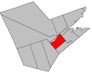
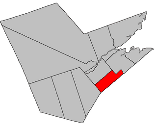
Location within Kent County, New Brunswick.
Coordinates: 46°19′39″N65°01′03″W / 46.3275°N 65.0175°W / 46.3275; -65.0175
Country Flag of Canada (Pantone).svg  Canada
Province Flag of New Brunswick.svg  New Brunswick
County Kent County
Erected1888
Area
[1]
  Land228.41 km2 (88.19 sq mi)
Population
 (2021) [1]
  Total877
  Density3.8/km2 (10/sq mi)
  Change 2016-2021
Increase2.svg 4.2%
  Dwellings
383
Time zone UTC-4 (AST)
  Summer (DST) UTC-3 (ADT)

Saint-Paul is a geographic parish in Kent County, New Brunswick, Canada. [4]

Contents

For governance purposes, most of the parish is within the town of Champdoré, with a strip along the northern boundary in the village of Five Rivers [5] and the southeastern corner part of the incorporated rural community of Maple Hills. [6] Champdoré and Five Rivers belong to the Kent Regional Service Commission, while Maple Hills belongs to the Southeast RSC. [7]

Prior to the 2023 governance reform, the parish formed the local service district of the parish of Saint-Paul. [8]

Origin of name

The parish may have taken its name from the Roman Catholic ecclesiastical parish.

History

Saint-Paul was erected in 1888 from all of Sainte-Marie Parish west of McLaughlin Road. [9]

Boundaries

Saint-Paul Parish is bounded: [2] [10] [11] [12]

Governance

The entire parish forms the local service district of the parish of Saint-Paul, [lower-alpha 2] established in 1966 to assess for fire protection. Community services were added in 1987, recreational and sports facilities in 2008, and non-fire related rescue in 2015. First aid and ambulance services (1982–2008) were formerly included.

Communities

Communities at least partly within the parish; [10] [11] [12] italics indicate a name no longer in official use

Bodies of water

Bodies of water [lower-alpha 3] at least partly in the parish: [10] [11] [12]

Other notable places

Parks, historic sites, and other noteworthy places at least partly in the parish. [10] [11] [12] [15]

Demographics

See also

Notes

  1. By the magnet of 1850, [13] when declination in the area was between 21º and 22º west of north. [14]
  2. The name was originally styled Saint Paul; this was changed to the modern form in 1985. The French name was in the modern style when the LSD regulation was made bilingual in 1984.
  3. Not including brooks, ponds or coves.

Related Research Articles

<span class="mw-page-title-main">Moncton Parish, New Brunswick</span> Parish in New Brunswick, Canada

Moncton is a geographic parish in Westmorland County, New Brunswick, Canada.

<span class="mw-page-title-main">Dundas Parish, New Brunswick</span> Parish in Canada

Dundas is a geographic parish in Kent County, New Brunswick, Canada.

<span class="mw-page-title-main">Richibucto Parish, New Brunswick</span> Parish in New Brunswick, Canada

Richibucto is a geographic parish in Kent County, New Brunswick, Canada.

<span class="mw-page-title-main">Wicklow Parish, New Brunswick</span> Parish in New Brunswick, Canada

Wicklow is a geographic parish in Carleton County, New Brunswick, Canada, forming the northwestern corner of Carleton County.

<span class="mw-page-title-main">Newcastle Parish, New Brunswick</span> Parish in New Brunswick, Canada

Newcastle is a geographic parish in Northumberland County, New Brunswick, Canada.

<span class="mw-page-title-main">Nelson Parish, New Brunswick</span> Parish in New Brunswick, Canada

Nelson is a geographic parish in Northumberland County, New Brunswick, Canada.

<span class="mw-page-title-main">Rogersville Parish, New Brunswick</span> Parish in New Brunswick, Canada

Rogersville is a geographic parish in Northumberland County, New Brunswick, Canada.

<span class="mw-page-title-main">Blackville Parish, New Brunswick</span> Parish in New Brunswick, Canada

Blackville is a geographic parish in Northumberland County, New Brunswick, Canada.

<span class="mw-page-title-main">Saint-Louis Parish, New Brunswick</span> Parish in New Brunswick, Canada

Saint-Louis is a geographic parish in Kent County, New Brunswick, Canada.

<span class="mw-page-title-main">Wellington Parish, New Brunswick</span> Parish in New Brunswick, Canada

Wellington is a geographic parish in Kent County, New Brunswick, Canada.

<span class="mw-page-title-main">Sainte-Marie Parish, New Brunswick</span> Parish in New Brunswick, Canada

Saint-Marie, is a geographic parish in Kent County, New Brunswick, Canada.

<span class="mw-page-title-main">Weldford Parish, New Brunswick</span> Parish in New Brunswick, Canada

Weldford is a geographic parish in Kent County, New Brunswick, Canada.

<span class="mw-page-title-main">Harcourt Parish, New Brunswick</span> Parish in New Brunswick, Canada

Harcourt is a geographic parish in Kent County, New Brunswick, Canada.

<span class="mw-page-title-main">Huskisson Parish, New Brunswick</span> Parish in New Brunswick, Canada

Huskisson is a geographic parish in Kent County, New Brunswick, Canada.

<span class="mw-page-title-main">Simonds Parish, Carleton County, New Brunswick</span> Parish in New Brunswick, Canada

Simonds is a geographic parish in Carleton County, New Brunswick, Canada, located north of Woodstock on the western bank of the Saint John River.

<span class="mw-page-title-main">Hillsborough Parish, New Brunswick</span> Parish in New Brunswick, Canada

Hillsborough is a geographic parish in eastern Albert County, New Brunswick, Canada.

<span class="mw-page-title-main">Hopewell Parish, New Brunswick</span> Parish in New Brunswick, Canada

Hopewell is a geographic parish in eastern Albert County, New Brunswick, Canada.

<span class="mw-page-title-main">Alma Parish, New Brunswick</span> Parish in New Brunswick, Canada

Alma is a geographic parish on the Bay of Fundy in the southwestern corner of Albert County, New Brunswick, Canada.

<span class="mw-page-title-main">Shediac Parish, New Brunswick</span> Parish in New Brunswick, Canada

Shediac is a geographic parish in Westmorland County, New Brunswick, Canada.

<span class="mw-page-title-main">Botsford Parish, New Brunswick</span> Parish in New Brunswick, Canada

Botsford is a geographic parish in Westmorland County, New Brunswick, Canada.

References

  1. 1 2 "Census Profile". Statistics Canada. 26 October 2022. Retrieved 30 October 2022.
  2. 1 2 "Chapter T-3 Territorial Division Act". Government of New Brunswick. Retrieved 26 February 2023.
  3. "Chapter I-13 Interpretation Act". Government of New Brunswick. Retrieved 26 February 2023.
  4. The Territorial Division Act [2] divides the province into 152 parishes, the cities of Saint John and Fredericton, and one town of Grand Falls. The Interpretation Act [3] clarifies that parishes include any local government within their borders.
  5. "Kent Regional Service Commission: RSC 6". Government of New Brunswick. Retrieved 26 February 2023.
  6. "Southeast Regional Service Commission: RSC 7". Government of New Brunswick. Retrieved 26 February 2023.
  7. "Regions Regulation – Regional Service Delivery Act". Government of New Brunswick. 21 July 2022. Retrieved 26 February 2023.
  8. "Local Service Districts Regulation - Municipalities Act". Government of New Brunswick. 25 June 2021. Retrieved 26 February 2023.
  9. "51 Vic. c. 71 An Act to erect part of the Parish of Saint Mary, in the County of Kent, into a separate Parish.". Acts of the General Assembly of Her Majesty's Province of New Brunswick. Passed in the Months of March and April, 1888. Fredericton: Government of New Brunswick. 1888. pp. 160–162. Available as a free ebook from Google Books.
  10. 1 2 3 4 "No. 99". Provincial Archives of New Brunswick. Department of Natural Resources and Energy Development. Retrieved 11 June 2021. Remainder of parish on map 109 at same site.
  11. 1 2 3 4 "284" (PDF). Transportation and Infrastructure. Government of New Brunswick. Retrieved 11 June 2021. Remainder of parish on mapbooks 285, 300, 301, 317, and 318 at same site.
  12. 1 2 3 4 "Search the Canadian Geographical Names Database (CGNDB)". Government of Canada. Retrieved 11 June 2021.
  13. "13 Vic. c. 51 An Act to consolidate all the Laws now in force for the division of the Province into Counties, Towns and Parishes.". Acts of the General Assembly of Her Mjaesty's Province of New Brunswick, Passed in the Year 1850. Fredericton: Government of New Brunswick. 1850. pp. 142–152, 145–149. Retrieved 27 March 2021. Book was poorly proofread, resulting in title typo and reuse of page numbers 145–152.
  14. "Historical Magnetic Declination". National Oceanic and Atmospheric Administration. Retrieved 2 March 2021.
  15. "Explore New Brunswick's Protected Natural Areas". GeoNB. Retrieved 2 July 2021.
  16. Statistics Canada: 1996, 2001, 2006 census
  17. 2011 Statistics Canada Census Profile: Saint-Paul Parish, New Brunswick
  18. 1 2 "Census Profile, 2016 Census Saint-Paul, Parish [Census subdivision], New Brunswick". Statistics Canada. Retrieved 15 September 2019.


46°19′39″N65°01′03″W / 46.32750°N 65.01750°W / 46.32750; -65.01750 (Saint-Paul Parish, New Brunswick)