
Gujarat is a state along the western coast of India. Its coastline of about 1,600 km (990 mi) is the longest in the country, most of which lies on the Kathiawar peninsula. Gujarat is the fifth-largest Indian state by area, covering some 196,024 km2 (75,685 sq mi); and the ninth-most populous state, with a population of 60.4 million. It is bordered by Rajasthan to the northeast, Dadra and Nagar Haveli and Daman and Diu to the south, Maharashtra to the southeast, Madhya Pradesh to the east, and the Arabian Sea and the Pakistani province of Sindh to the west. Gujarat's capital city is Gandhinagar, while its largest city is Ahmedabad. The Gujaratis are indigenous to the state and their language, Gujarati, is the state's official language.

Girnar is an ancient hill in Junagadh, Gujarat, India.
Waghai is a town in the Dang District of the southern part of Gujarat state in India. And also Taluka of dang district. Waghai is about 32 km west of the district headquarters of Ahwa, and about 52 km north-west of the hill station of Saputara. Vansda, Chikhli and Bilimora are located westerly. It is linked by state highway to the town of Chikhli, and by a narrow gauge to the town of Bilimora. Also with Saputara a NG passenger train named. Waghai Passenger link these towns of south Gujarat.
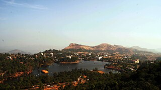
Saputara is a hill station located in Sahyadris or Western Ghats. Saputara town is part of Dang district in Gujarat, India. It is a tourist destination.

Champaner-Pavagadh Archaeological Park, a UNESCO World Heritage Site, is located in Panchmahal district in Gujarat, India. It is located around the historical city of Champaner, a city which was founded by Vanraj Chavda, the most prominent king of the Chavda Dynasty, in the eighth century. He named it after the name of his friend and general Champa, also known later as Champaraj. The heritage site is studded with forts with bastions starting from the hills of Pavagadh, and extending into the city of Champaner. The park's landscape includes archaeological, historic and living cultural heritage monuments such as chalcolithic sites, a hill fortress of an early Hindu capital, and remains of the 16th-century capital of the state of Gujarat. There are palaces, entrance gates and arches, mosques, tombs and temples, residential complexes, agricultural structures and water installations such as stepwells and tanks, dating from the eighth to the 14th centuries. The Kalika Mata Temple, located on top of the 800 metres (2,600 ft) high Pavagadh Hill, is an important Hindu shrine in the region, attracting large numbers of pilgrims throughout the year.
Bilimora is a city situated on the banks of the river Ambika, in Gandevi taluka & Navsari district of Gujarat state, in India. The city comes under the purview of the Surat Metropolitan Region. The city is roughly 70 kilometres (43 mi) south of the city of Surat and is the southernmost point of the Surat Metropolitan Region and the Metropolis of Surat. It is linked to Surat by SH 6 and SH 88.
Poornima Arvind Pakvasa, known as the Didi of Dangs, was an Indian independence activist and social worker from Gujarat.

South Gujarat, also known as Dakshin Gujarat, is a region in the Indian state of Gujarat. The region has a wetter climate than other regions of Gujarat. The western part is almost coastal and is known as Kantha Vistar, and the eastern part is also known as Dungar Vistar, which ranges from 100 to 1000 metres, with the highest peak at Saputara in the Dang district.

Gujarat is a state along the western coast of India. Its coastline of about 1,600 km (990 mi) is the longest in the country, most of which lies on the Kathiawar peninsula. Gujarat is the fifth-largest Indian state by area, covering some 196,024 km2 (75,685 sq mi); and the ninth-most populous state, with a population of 60.4 million. It is a popular tourist destination in the country and was visited by 19.5 million domestic tourists and 210 thousand international tourists in 2020.
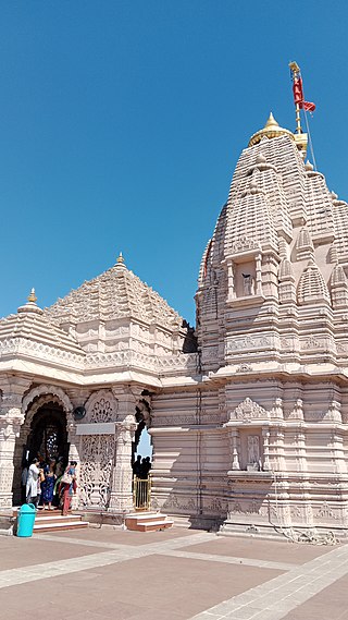
Kālikā Mata Temple is a Hindu goddess temple complex and pilgrim centre at the summit of Pavagadh Hill in Panchmahal District, India, with in the Champaner-Pavagadh Archaeological Park. It dates from the 10th or 11th centuries. The temple has three images of goddesses: the central image is of Kalika Mata, flanked by Kali on the right and Bahucharamata on the left. On Chitra sud 8, a fair is held at the temple which is attended by thousands of devotees. The temple is the site of one of the Great holy Shakti Peethas. One can easily reach the temple by ropeway.
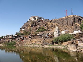
Pavagadh Hill is situated within a plain in Panchmahal district, Gujarat, western India. A volcanic eruption occurred in the region approximately 500 million years ago and the etymology of Pavagadh is associated with this eruption: Pav-gadh means "one fourth hill" or "fire-hill". At its base is the historical city of Champaner, while the hill station of Pavagadh was built upon the volcanic cone itself. With Champaner, Pavagadh hill forms the Champaner-Pavagadh Archaeological Park, a UNESCO World Heritage Site which is spread over an area of more than 1,329 hectares. Known for its forts, there are also dozens of heritage structures on the hill. The site is 50 kilometres (31 mi) east of Vadodara and 68 kilometres (42 mi) south of Godhra.

The Media in Gujarati language started with publication of Bombay Samachar in 1822. Initially the newspapers published business news and they were owned by Parsi people based in Bombay. Later Gujarati newspapers started published from other parts of Gujarat. Several periodicals devoted to social reforms were published in the second half of the 19th century. After arrival of Mahatma Gandhi, the Indian independence movement peaked and it resulted in proliferation of Gujarati media. Following independence, the media was chiefly focused on political news. After bifurcation of Bombay state, the area of service changed. Later there was an increase in readership due to growth of literacy and the media houses expanded its readership by publishing more editions. Later these media houses ventured into digital media also. The radio and television media expanded after 1990.
Don is a hill station and village in Dang district of Gujarat, India. It is touted to be the second hill station in state after nearby Saputara.
Hatgad Fort is a fort located 71 km (44 mi)from Nashik, Nashik district, of Maharashtra. The base village is Hatgad on the Nashik-Saputara Road. The nearest town is Saputara, which is 6 km from Hatgad village. It is a historic monument located in Maharashtra, India, south of the hill station of Saputara and near the border with Gujarat. It was built by the Maratha king chhatrapati Shivaji Maharaj and is located at an elevation of about 3,600 feet. The way to reach the fort is through a trekking route via a narrow rocky path and car also go up to the stairs of fort. A statue of Lord Shivling is placed on the top of the fort.
The Tourism Corporation of Gujarat, operating under the brand of Gujarat Tourism, is a government undertaking formed in 1978 to promote tourism in the Indian state of Gujarat and guide tourists visiting Gujarat.

Girnar ropeway is a ropeway on Mount Girnar in Junagadh district, Gujarat, India. First proposed in 1983, the construction started only in September 2018 due to government approval delays and litigation. The construction and operation is managed by Usha Breco Limited. It was inaugurated on 24 October 2020.

Pavagadh ropeway is a ropeway on Pavagadh hill in Pavagadh, Panchmahal district, Gujarat, India. It was opened in 1986.

Ambaji ropeway is a ropeway on Gabbar hill in Ambaji, Banaskantha district, Gujarat, India. It was opened in 1998.
Saputara Lake is a man made lake situated in the Dang District, Gujarat, India. The Saputara Lake is located at a mere distance of 1 kilometer from the main city hill station. Saputara town is part of Dang district in Gujarat. It is a tourist destination.

The Aerial tramway, also known as Aerial lift or Aerial ropeway and cable car popularly known as ropeway in India, is a public transportation system where cabins, gondolas or open chairs are hauled above the ground with the help of cables. They are usually built in mountainous areas where it is difficult to build roads or railway.


