Saratoga, Indiana

Last updated

Saratoga, Indiana
Saratoga, Indiana.jpg
Randolph County Indiana Incorporated and Unincorporated areas Saratoga Highlighted 1868058.svg
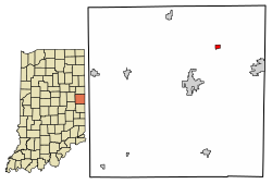
Location of Saratoga in Randolph County, Indiana.
Coordinates: 40°14′13″N84°54′57″W / 40.23694°N 84.91583°W / 40.23694; -84.91583
Country United States
State Indiana
County Randolph
Township Ward
Area
[1]
  Total0.27 sq mi (0.69 km2)
  Land0.27 sq mi (0.69 km2)
  Water0.00 sq mi (0.00 km2)
Elevation
[2]
1,053 ft (321 m)
Population
 (2020)
  Total231
  Density871.70/sq mi (336.94/km2)
Time zone UTC-5 (Eastern (EST))
  Summer (DST) UTC-4 (EDT)
ZIP code
47382
Area code 765
FIPS code 18-68058 [3]
GNIS feature ID2396906 [2]

Saratoga is a town in Ward Township, Randolph County, in the U.S. state of Indiana. [2] The population was 254 at the 2010 census.

Contents

History

A post office has been in operation at Saratoga since 1867. [4] Saratoga was platted in 1875. [5]

Geography

According to the 2010 census, Saratoga has a total area of 0.26 square miles (0.67 km2), all land. [6]

Demographics

Historical population
CensusPop.Note
1880 136
1910 410
1920 327−20.2%
1930 303−7.3%
1940 34915.2%
1950 333−4.6%
1960 3639.0%
1970 40611.8%
1980 338−16.7%
1990 266−21.3%
2000 2888.3%
2010 254−11.8%
2020 231−9.1%
U.S. Decennial Census [7]

2010 census

As of the census [8] of 2010, there were 254 people, 102 households, and 66 families living in the town. The population density was 940.7 inhabitants per square mile (363.2/km2). There were 124 housing units at an average density of 459.3 per square mile (177.3/km2). The racial makeup of the town was 98.8% White, 0.8% from other races, and 0.4% from two or more races. Hispanic or Latino of any race were 2.0% of the population.

There were 102 households, of which 37.3% had children under the age of 18 living with them, 51.0% were married couples living together, 8.8% had a female householder with no husband present, 4.9% had a male householder with no wife present, and 35.3% were non-families. 30.4% of all households were made up of individuals, and 15.7% had someone living alone who was 65 years of age or older. The average household size was 2.49 and the average family size was 3.14.

The median age in the town was 36.5 years. 28.7% of residents were under the age of 18; 11.1% were between the ages of 18 and 24; 24% were from 25 to 44; 21.6% were from 45 to 64; and 14.6% were 65 years of age or older. The gender makeup of the town was 45.7% male and 54.3% female.

2000 census

As of the census [3] of 2000, there were 288 people, 118 households, and 77 families living in the town. The population density was 1,090.9 inhabitants per square mile (421.2/km2). There were 130 housing units at an average density of 492.4 per square mile (190.1/km2). The racial makeup of the town was 98.26% White, 0.69% African American, 1.04% from other races. Hispanic or Latino of any race were 3.12% of the population.

There were 118 households, out of which 30.5% had children under the age of 18 living with them, 55.9% were married couples living together, 8.5% had a female householder with no husband present, and 33.9% were non-families. 29.7% of all households were made up of individuals, and 12.7% had someone living alone who was 65 years of age or older. The average household size was 2.44 and the average family size was 3.08.

In the town, the population was spread out, with 26.0% under the age of 18, 10.1% from 18 to 24, 26.0% from 25 to 44, 20.5% from 45 to 64, and 17.4% who were 65 years of age or older. The median age was 35 years. For every 100 females, there were 93.3 males. For every 100 females age 18 and over, there were 86.8 males.

The median income for a household in the town was $30,000, and the median income for a family was $39,688. Males had a median income of $29,167 versus $13,750 for females. The per capita income for the town was $14,669. About 5.3% of families and 6.9% of the population were below the poverty line, including 7.9% of those under the age of eighteen and 7.0% of those 65 or over.

Education

Saratoga residents may obtain a free library card from the Winchester Community Public Library in Winchester. [9]

Related Research Articles

<span class="mw-page-title-main">Saratoga, Wyoming</span> Town in Wyoming, United States

Saratoga is a town in Carbon County, Wyoming, United States. The population was 1,690 at the 2010 census.

<span class="mw-page-title-main">Losantville, Indiana</span> Town in Indiana, United States

Losantville is a town in Union Township, Randolph County, in the U.S. state of Indiana. The population was 237 at the 2010 census.

<span class="mw-page-title-main">Modoc, Indiana</span> Town in Indiana, United States

Modoc is a town in Union Township, Randolph County, in the U.S. state of Indiana. The population was 196 at the 2010 census.

<span class="mw-page-title-main">Parker City, Indiana</span> Town in Indiana, United States

Parker City is a town in Monroe Township, Randolph County, in the U.S. state of Indiana. The population was 1,419 at the 2010 census.

<span class="mw-page-title-main">Ridgeville, Indiana</span> Town in Indiana, United States

Ridgeville is a town in Franklin Township, Randolph County, Indiana, United States, along the Mississinewa River. The population was 688 at the 2020 census.

<span class="mw-page-title-main">Winchester, Indiana</span> City in Indiana, United States

Winchester is a city in White River Township, Randolph County, in the U.S. state of Indiana. The city is the county seat of Randolph County. The population was 4,935 at the 2010 census. It is the home of Winchester Speedway.

<span class="mw-page-title-main">Randolph, Kansas</span> City in Riley County, Kansas

Randolph is a city in Riley County, Kansas, United States. As of the 2020 census, the population of the city was 159.

<span class="mw-page-title-main">Winchester, Missouri</span> City in Missouri, United States

Winchester is a city in St. Louis County, Missouri, United States. The population was 1,447 at the 2020 census.

<span class="mw-page-title-main">Randolph, Nebraska</span> City in Nebraska, United States

Randolph is a city in Cedar County, Nebraska, United States. The population was 881 at the 2020 census. It refers to itself as "The Honey Capital of the Nation" due to the per-capita number of bee keeping families.

<span class="mw-page-title-main">Saratoga, North Carolina</span> Town in North Carolina, United States

Saratoga is a town in Wilson County, North Carolina, United States. The population was 408 at the 2010 census.

<span class="mw-page-title-main">Capon Bridge, West Virginia</span> Town in West Virginia, United States

Capon Bridge is a town in eastern Hampshire County, West Virginia, United States, along the Northwestern Turnpike, approximately 20 miles (32 km) west of Winchester, Virginia. The population was 418 at the 2020 census. Originally known as "Glencoe", Capon Bridge was incorporated in 1902 by the Hampshire County Circuit Court. It is named because of the construction of the bridge over the Cacapon River at that place, the name of the river being derived from the Shawnee Cape-cape-de-hon, meaning "river of medicine water".

<span class="mw-page-title-main">Mill Creek, West Virginia</span> Town in West Virginia, United States

Mill Creek is a town in Randolph County, West Virginia, United States, along the Tygart Valley River. The population was 563 at the 2020 census.

<span class="mw-page-title-main">Montrose, West Virginia</span> Town in West Virginia, United States

Montrose is a town in Randolph County, West Virginia, United States. The population was 141 at the 2020 census.

<span class="mw-page-title-main">Womelsdorf (Coalton), West Virginia</span> Town in West Virginia, United States

Womelsdorf (Coalton) is a town in Randolph County, West Virginia, United States. The population was 190 at the 2020 census.

<span class="mw-page-title-main">Winchester, Winnebago County, Wisconsin</span> Town in Wisconsin, United States

Winchester is a town in Winnebago County, Wisconsin, United States. The population was 1,763 at the 2010 census. The census-designated place of Winchester and the unincorporated communities of Clarks Point, Indian Shores, Lasleys Point, and Piacenza are located in the town.

<span class="mw-page-title-main">Randolph, Maine</span> Town in the state of Maine, United States

Randolph is a town and a census-designated place (CDP) in Kennebec County, Maine, United States. The population was 1,743 at the 2020 census. The town was named for Randolph, Massachusetts. Randolph is included in the Augusta, Maine micropolitan New England City and Town Area.

<span class="mw-page-title-main">Randolph (town), Wisconsin</span> Town in Wisconsin, United States

Randolph is a town in Columbia County, Wisconsin, United States. The population was 699 at the 2000 census. The Village of Randolph lies to the southeast of the town and only a tiny portion of the village is within the town. The unincorporated community of East Friesland is located in the town. The unincorporated community of Ingle is also located partially in the town.

<span class="mw-page-title-main">Randolph, Wisconsin</span> Village in Wisconsin, United States

Randolph is a village in Columbia and Dodge Counties in the U.S. state of Wisconsin. The population was 1,811 at the 2010 census. Of this, 1,339 were in Dodge County, and 472 were in Columbia County. The village is located at the southeast corner of the Town of Randolph in Columbia County, although only a tiny portion of the village lies within the town. Most of the village lies within the Town of Westford in Dodge County. Small portions also lie within the Town of Fox Lake to the north and the Town of Courtland in Columbia County.

<span class="mw-page-title-main">Star Prairie, Wisconsin</span> Village in Wisconsin, United States

Star Prairie is a village in St. Croix County in the U.S. state of Wisconsin. The population was 561 at the 2010 census. The village is located along the Apple River on the boundary between the Town of Star Prairie and the Town of Stanton.

<span class="mw-page-title-main">Winchester, Adams County, Ohio</span> Village in Ohio, United States

Winchester is a village in Adams County, Ohio, United States. The population was 987 at the 2020 census. The name of the surrounding township is also named Winchester.

References

  1. "2020 U.S. Gazetteer Files". United States Census Bureau. Retrieved March 16, 2022.
  2. 1 2 3 U.S. Geological Survey Geographic Names Information System: Saratoga, Indiana
  3. 1 2 "U.S. Census website". United States Census Bureau . Retrieved January 31, 2008.
  4. "Randolph County". Jim Forte Postal History. Retrieved November 1, 2015.
  5. Tucker, E. (1882). History of Randolph County, Indiana: With Illustrations and Biographical Sketches of Some of Its Prominent Men and Pioneers : to which are Appended Maps of Its Several Townships. A.L. Klingman. p.  417.
  6. "G001 - Geographic Identifiers - 2010 Census Summary File 1". United States Census Bureau. Archived from the original on February 13, 2020. Retrieved July 25, 2015.
  7. "Census of Population and Housing". Census.gov. Retrieved June 4, 2015.
  8. "U.S. Census website". United States Census Bureau . Retrieved December 11, 2012.
  9. "Library Information". Winchester Community Public Library. Retrieved March 14, 2018.