Scientific information from the Mars Exploration Rover mission

Last updated

Artist's Concept of Rover on Mars (credit: Maas Digital LLC) NASA Mars Rover.jpg
Artist's Concept of Rover on Mars (credit: Maas Digital LLC)

NASA's 2003 Mars Exploration Rover Mission has amassed an enormous amount of scientific information related to the Martian geology and atmosphere, as well as providing some astronomical observations from Mars. This article covers information gathered by the Opportunity rover during the initial phase of its mission. Information on science gathered by Spirit can be found mostly in the Spirit rover article.

Contents

The unmanned Mars exploration mission, commenced in 2003 sent two robotic rovers, Spirit and Opportunity, to explore the Martian surface and geology. The mission was led by Project Manager Peter Theisinger of NASA's Jet Propulsion Laboratory and Principal Investigator Steven Squyres, professor of astronomy at Cornell University.

Primary among the mission's scientific goals is to search for and characterize a wide range of rocks and soils that hold clues to past water activity on Mars. In recognition of the vast amount of scientific information amassed by both rovers, two asteroids have been named in their honor: 37452 Spirit and 39382 Opportunity.

On January 24, 2014, NASA reported that current studies on the planet Mars by the Curiosity and Opportunity rovers will now be searching for evidence of ancient life, including a biosphere based on autotrophic, chemotrophic or chemolithoautotrophic microorganisms, as well as ancient water, including fluvio-lacustrine environments (plains related to ancient rivers or lakes) that may have been habitable. [1] [2] [3] [4] The search for evidence of habitability, taphonomy (related to fossils), and organic carbon on the planet Mars is now a primary NASA objective. [1]

Water hypothesis

On March 2, 2004, NASA announced that "Opportunity has landed in an area of Mars where liquid water once drenched the surface". Associate administrator Ed Weiler told reporters that the area "would have been good habitable environment", although no traces of life have been found.

Larger grains suggest the presence of fluid. PIA05480 modest.jpg
Larger grains suggest the presence of fluid.

This statement was made during a press conference, where mission scientists listed a number of observations that strongly support this view:

Hypothesis: Spherules are concretions created in water as a solvent.
Competing hypothesis: Spherules are rehardened molten rock droplets, created by volcanoes or meteor strikes.
Supporting data: Location of spherules in the rock matrix is random and evenly spread.
Quote from Steve Squyres: "The little spherules like blueberries in a muffin are embedded in this rock and weathering out of it. Three ideas, lapilli, little volcanic hailstones, one possibility. Two, droplets of volcanic glass or impact. We've looked at these things very carefully. Probably concretions. If so, it's pointing towards water."

Detailed analysis of environmental, chemical, and mineralogical data taken from the Opportunity rover led to the elimination of the competing hypotheses, and the confirmation of the conclusion that the spherules were formed in place as post-depositional sedimentary concretions from an aqueous source [5]

In the lower left, a spherule can be seen penetrating the interior of a vug. PIA05481 modest.jpg
In the lower left, a spherule can be seen penetrating the interior of a vug.
Hypothesis: Rock was formed in water, for instance by precipitation.
Competing hypothesis: Rock were formed by ash deposits.
Supporting data: Voids found in bedrock resemble "vugs" which are left by eroded away, disk-shaped crystals, possibly dissolved in a watery environment.
Quote from Steve Squyres: The second piece of evidence is that when we looked at it close-up, it was shot through with tabular holes. Familiar forms. When crystals grow within rocks, precipitated from water. If they're tabular, as they grow you can get tabular crystals and water chem changes and they go away or they weather away."
Hypothesis: Water created tell-tale salt chemicals in the rock.
Competing hypothesis: Chemistry of rocks is determined by volcanic processes.
Supporting data: Sulfate salts and jarosite mineral were found in the rock. On Earth they are made in standing water (possibly during evaporation).
Quote from Steve Squyres: "Next piece of evidence comes from APXS. We found it looked like a lot of sulfur. That was the outside of the rock. We brought with us a grinding tool, the RAT and we ground away 2-4 mm and found even more sulfur. Too much to explain by other than that this rock is full of sulfate salts. That's a telltale sign of liquid water. Mini-TES also found evidence of sulfate salts. Most compelling of all, the Mössbauer spectrometer in the RATted space showed compelling evidence of jarosite, an iron-(III) sulfate basic hydrate. Fairly rare, found on Earth and had been predicted that it might be found on Mars some day. This is a mineral that you got to have water around to make."
Crossbedding features in rock "Last Chance". LastChance D JG03-B058R1 br.jpg
Crossbedding features in rock "Last Chance".

On March 23, 2004, NASA announced that they believe that Opportunity had not landed in a location merely "drenched in water", but on what was once a coastal area. "We think Opportunity is parked on what was once the shoreline of a salty sea on Mars," said Dr. Steve Squyres of Cornell University.

The announcement was based on evidence of sedimentary rocks that are consistent with those formed by water and not wind. "Bedding patterns in some finely layered rocks indicate the sand-sized grains of sediment that eventually bonded together were shaped into ripples by water at least five centimeters (two inches) deep, possibly much deeper, and flowing at a speed of 10 to 50 centimeters (four to 20 inches) per second," said Dr. John Grotzinger, from MIT. The landing site was likely a salt flat on the edge of a large body of water that was covered by shallow water.

Other evidence includes findings of chlorine and bromine in the rocks which indicates the rocks had at least soaked in mineral-rich water, possibly from underground sources, after they formed. Increased assurance of the bromine findings strengthens the case that rock-forming particles precipitated from surface water as salt concentrations climbed past saturation while water was evaporating.

The evidence for water was published in a series of scientific papers, with the initial results appearing in the journal Science [6] and then with a detailed discussion of the sedimentary geology of the landing site appearing in a special issue of the journal Earth and Planetary Science Letters [7]

Spherules and hematite

Early in the mission, mission scientists were able to prove that the abundant spherules at Eagle crater were the source of hematite in the area discovered from orbit.

Hematite

The distribution of hematite in Sinus Meridiani, where Meridiani Planum is located. Hematite region Sinus Meridiani sur Mars.jpg
The distribution of hematite in Sinus Meridiani, where Meridiani Planum is located.

Geologists were eager to reach a hematite-rich area (in the center of the picture at right) to closely examine the soil, which may reveal secrets about how the hematite got to this location. Knowing how the hematite on Mars was formed may help scientists characterize the past environment and determine whether that environment provided favorable conditions for life.

"Grey hematite is a mineral indicator of past water," said Dr. Joy Crisp, JPL project scientist. "It is not always associated with water, but it often is."

Scientists have wanted to find out which of these processes created grey hematite on Mars since 1998, when Mars Global Surveyor spotted large concentrations of the mineral near the planet's equator (seen in the right picture). This discovery provided the first mineral evidence that Mars' history may have included water.

"We want to know if the grains of hematite appear to be rounded and cemented together by the action of liquid water or if they're crystals that grew from a volcanic melt," said Crisp. "Is the hematite in layers, which would suggest that it was laid down by water, or in veins in the rock, which would be more characteristic of water having flowed through the rocks."

The next picture shows a mineral map, the first ever made on the surface of another planet, which was generated from a section of the panorama picture overlaid with data taken from the rover's Mini-TES. The Mini-TES spectral data was analyzed in a way that the concentration of the mineral hematite was deduced and its level coded in color. Red and orange mean high concentration, green and blue low concentration.

This spectral map of Eagle crater shows hematite. Hematite new-B011R1 th543h.jpg
This spectral map of Eagle crater shows hematite.

The next picture shows a hematite abundance "index map" that helps geologists choose hematite-rich locations to visit around Opportunity's landing site. Blue dots equal areas low in hematite and red dots equal areas high in hematite. The colored dots represent data collected by the miniature Thermal Emission Spectrometer on Sol 11, after Opportunity had rolled off of the lander and the rover was located at the center of the blue semicircle (the spectrometer is located on the panoramic camera mast).

A hematite abundance index map of Eagle crater. Hem strip1 br.jpg
A hematite abundance index map of Eagle crater.

The area to the left (with high concentration of hematite) was selected by mission members for further investigation, and called Hematite Slope.

During Sol 23 (February 16) Opportunity successfully trenched the soil at Hematite Slope and started to investigate the details of the layering.

Spherules

This color-enhanced image shows spherical granules. Mib color1 rgbstretch-B011R1 br.jpg
This color-enhanced image shows spherical granules.

Microscopic images of the soil taken by Opportunity revealed small spherically shaped granules. They were first seen on pictures taken on Sol 10, right after the rover drove from the lander onto martian soil.

When Opportunity dug her first trench (Sol 23), pictures of the lower layers showed similar round spherules. But this time they had a very shiny surface that created strong glints and glares. "They appear shiny or polished," said Albert Yen, science team member, during a press conference on February 19. He said: "Data will hopefully help us figure out what's altering them." At the same press briefing, Dr. Squyres noted this as one of the main question: "Where did those spherules come from, dropped from above or grown in place?"

Mission scientists reported on March 2 that they concluded a survey of the distribution of spherules in the bedrock. They found that they spread out evenly and randomly inside the rocks, and not in layers. This supports the notion that they grew in place, since if their origin was related to volcanic or meteoric episodes one would expect layers of spherules as a "record in time" for each event. This observation was added to the list of evidence for liquid water being present at this rock site, where it is thought the spherules formed.

Berry Bowl

The rock "Berry Bowl". Xpe pubeng approved 032304 color berry bowl-B060R1 br.jpg
The rock "Berry Bowl".

On March 18 the results of the investigation of the area called "Berry Bowl" was announced. This site is a large rock with a small, bowl-shaped depression, in which a large number of spherules had accumulated. The MIMOS II Mössbauer spectrometer was used to analyze the depression and then the area of the rock right beside it. Any difference in the measured data was then attributed to the material in the spherules. A large difference in the obtained "spectra" was found. "This is the fingerprint of hematite, so we conclude that the major iron-bearing mineral in the berries is hematite," said Daniel Rodionov, a rover science team collaborator from the University of Mainz, Germany. This discovery seems to strengthen the conclusion, that spherules are concretions, grown in wet condition with dissolved iron.

Rocks and minerals

The rocks on the plains of Gusev are a type of basalt. They contain the minerals olivine, pyroxene, plagioclase, and magnetite, and they look like volcanic basalt as they are fine-grained with irregular holes (geologists would say they have vesicles and vugs). [8] [9] Much of the soil on the plains came from the breakdown of the local rocks. Fairly high levels of nickel were found in some soils; probably from meteorites. [10] Analysis shows that the rocks have been slightly altered by tiny amounts of water. Outside coatings and cracks inside the rocks suggest water deposited minerals, maybe bromine compounds. All the rocks contain a fine coating of dust and one or more harder rinds of material. One type can be brushed off, while another needed to be ground off by the Rock Abrasion Tool (RAT). [11]

There are a variety of rocks in the Columbia Hills (Mars), some of which have been altered by water, but not by very much water.

The dust in Gusev Crater is the same as dust all around the planet. All the dust was found to be magnetic. Moreover, Spirit found the magnetism was caused by the mineral magnetite, especially magnetite that contained the element titanium. One magnet was able to completely divert all dust hence all Martian dust is thought to be magnetic. [12] The spectra of the dust was similar to spectra of bright, low thermal inertia regions like Tharsis and Arabia that have been detected by orbiting satellites. A thin layer of dust, maybe less than one millimeter thick covers all surfaces. Something in it contains a small amount of chemically bound water. [13] [14]

Plains

Adirondack
Adirondacksquare.jpg
Rat post grind.jpg
Above: An approximate true color view of Adirondack, taken by Spirit's pancam.
Right:Digital camera image (from Spirit's Pancam) of Adirondack after a RAT grind (Spirit's rock grinding tool)
Feature typeRock
Coordinates 14°36′S175°30′E / 14.6°S 175.5°E / -14.6; 175.5

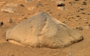
Observations of rocks on the plains show they contain the minerals pyroxene, olivine, plagioclase, and magnetite. These rocks can be classified in different ways. The amounts and types of minerals make the rocks primitive basalts—also called picritic basalts. The rocks are similar to ancient terrestrial rocks called basaltic komatiites. Rocks of the plains also resemble the basaltic shergottites, meteorites which came from Mars. One classification system compares the amount of alkali elements to the amount of silica on a graph; in this system, Gusev plains rocks lay near the junction of basalt, picrobasalt, and tephrite. The Irvine-Barager classification calls them basalts. [15] Plain's rocks have been very slightly altered, probably by thin films of water because they are softer and contain veins of light colored material that may be bromine compounds, as well as coatings or rinds. It is thought that small amounts of water may have gotten into cracks inducing mineralization processes. [9] [15] Coatings on the rocks may have occurred when rocks were buried and interacted with thin films of water and dust. One sign that they were altered was that it was easier to grind these rocks compared to the same types of rocks found on Earth.

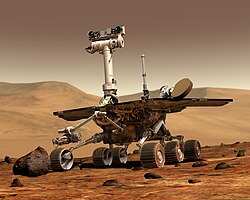
The first rock that Spirit studied was Adirondack. It turned out to be typical of the other rocks on the plains.

Columbia Hills

Scientists found a variety of rock types in the Columbia Hills, and they placed them into six different categories. The six are: Clovis, Wishbone, Peace, Watchtower, Backstay, and Independence. They are named after a prominent rock in each group. Their chemical compositions, as measured by APXS, are significantly different from each other. [16] Most importantly, all of the rocks in Columbia Hills show various degrees of alteration due to aqueous fluids. [17] They are enriched in the elements phosphorus, sulfur, chlorine, and bromine—all of which can be carried around in water solutions. The Columbia Hills' rocks contain basaltic glass, along with varying amounts of olivine and sulfates. [18] [19] The olivine abundance varies inversely with the amount of sulfates. This is exactly what is expected because water destroys olivine but helps to produce sulfates.

Acid fog is believed to have changed some of the Watchtower rocks. This was in a 200 meter long section of Cumberland Ridge and the Husband Hill summit. Certain places became less crystalline and more amorphous. Acidic water vapor from volcanoes dissolved some minerals forming a gel. When water evaporated a cement formed and produced small bumps. This type of process has been observed in the lab when basalt rocks are exposed to sulfuric and hydrochloric acids. [20] [21] [22]

The Clovis group is especially interesting because the Mössbauer spectrometer(MB) detected goethite in it. [23] Goethite forms only in the presence of water, so its discovery is the first direct evidence of past water in the Columbia Hills's rocks. In addition, the MB spectra of rocks and outcrops displayed a strong decline in olivine presence, [18] although the rocks probably once contained much olivine. [24] Olivine is a marker for the lack of water because it easily decomposes in the presence of water. Sulfate was found, and it needs water to form. Wishstone contained a great deal of plagioclase, some olivine, and anhydrate (a sulfate). Peace rocks showed sulfur and strong evidence for bound water, so hydrated sulfates are suspected. Watchtower class rocks lack olivine consequently they may have been altered by water. The Independence class showed some signs of clay (perhaps montmorillonite a member of the smectite group). Clays require fairly long term exposure to water to form. One type of soil, called Paso Robles, from the Columbia Hills, may be an evaporate deposit because it contains large amounts of sulfur, phosphorus, calcium, and iron. [25] Also, MB found that much of the iron in Paso Robles soil was of the oxidized, Fe+++ form, which would happen if water had been present. [13]

Towards the middle of the six-year mission (a mission that was supposed to last only 90 days), large amounts of pure silica were found in the soil. The silica could have come from the interaction of soil with acid vapors produced by volcanic activity in the presence of water or from water in a hot spring environment. [26]

After Spirit stopped working scientists studied old data from the Miniature Thermal Emission Spectrometer, or Mini-TES and confirmed the presence of large amounts of carbonate-rich rocks, which means that regions of the planet may have once harbored water. The carbonates were discovered in an outcrop of rocks called "Comanche." [27] [28]

In summary, Spirit found evidence of slight weathering on the plains of Gusev, but no evidence that a lake was there. However, in the Columbia Hills there was clear evidence for a moderate amount of aqueous weathering. The evidence included sulfates and the minerals goethite and carbonates which only form in the presence of water. It is believed that Gusev crater may have held a lake long ago, but it has since been covered by igneous materials. All the dust contains a magnetic component which was identified as magnetite with some titanium. Furthermore, the thin coating of dust that covers everything on Mars is the same in all parts of Mars.

First atmospheric temperature profile

Temperature profile taken by MGS over the MER-B site. 21-pc-06-temp-profile-B046R1 br.jpg
Temperature profile taken by MGS over the MER-B site.

During a press conference on March 11, 2004, mission scientists presented the first temperature profile of the martian atmosphere ever measured. It was obtained by combining data taken from the Opportunity Mini-TES infrared spectrometer with data from the TES instrument on board the Mars Global Surveyor (MGS) orbiter. This was necessary because Opportunity can only see up to 6 km high, and the MGS camera could not measure data all the way down to the ground. The data was acquired on February 15 (Sol 22) and is split into two data sets: Since the orbiter is in motion, some data was taken while it was approaching the Opportunity site, other when it was moving away. In the graph, these sets are marked "inbound" (black color) and "outbound" (red color). The dots represent Mini-TES (= rover) data and the straight lines are TES (=orbiter) data.

Atmospheric science from the MER rovers has been published in a series of scientific papers in Science [29] [30] and Journal of Geophysical Research [31]

Astronomical observations

Opportunity observed the eclipse, or transits of Phobos and transits of Deimos across the Sun, [32] and photographed the Earth, which appeared as a bright celestial object in the Martian sky.

A transit of Mercury from Mars took place on January 12, 2005 from about 14:45 UTC to 23:05 UTC, but camera resolution did not permit seeing Mercury's 6.1" angular diameter.

Transits of Deimos across the Sun were seen, but at 2' angular diameter, Deimos is about 20 times larger than Mercury's 6.1" angular diameter.

See also

Related Research Articles

<span class="mw-page-title-main">Mars Exploration Rover</span> NASA mission to explore Mars via two rovers

NASA's Mars Exploration Rover (MER) mission was a robotic space mission involving two Mars rovers, Spirit and Opportunity, exploring the planet Mars. It began in 2003 with the launch of the two rovers to explore the Martian surface and geology; both landed on Mars at separate locations in January 2004. Both rovers far outlived their planned missions of 90 Martian solar days: MER-A Spirit was active until March 22, 2010, while MER-B Opportunity was active until June 10, 2018.

<span class="mw-page-title-main">Gusev (Martian crater)</span> Crater on Mars

Gusev is a crater on the planet Mars and is located at 14.5°S 175.4°E and is in the Aeolis quadrangle. The crater is about 166 kilometers in diameter and formed approximately three to four billion years ago. It was named after Russian astronomer Matvey Gusev (1826–1866) in 1976.

<span class="mw-page-title-main">Meridiani Planum</span> Plain located 2 degrees south of Mars equator

The Meridiani Planum (alternately Meridiani plain, Meridiani plains, Terra Meridiani, or Terra Meridiani plains) is either a large plain straddling the equator of Mars and covered with a vast number of spherules containing a lot of iron oxide or a region centered on this plain that includes some adjoining land. The plain sits on top of an enormous body of sediments that contains a lot of bound water. The iron oxide in the spherules is crystalline (grey) hematite (Fe203).

<i>Spirit</i> (rover) NASA Mars rover, active from 2004 to 2010

Spirit, also known as MER-A or MER-2, is a Mars robotic rover, active from 2004 to 2010. Spirit was operational on Mars for 2208 sols or 3.3 Martian years. It was one of two rovers of NASA's Mars Exploration Rover Mission managed by the Jet Propulsion Laboratory (JPL). Spirit landed successfully within the impact crater Gusev on Mars at 04:35 Ground UTC on January 4, 2004, three weeks before its twin, Opportunity (MER-B), which landed on the other side of the planet. Its name was chosen through a NASA-sponsored student essay competition. The rover got stuck in a "sand trap" in late 2009 at an angle that hampered recharging of its batteries; its last communication with Earth was on March 22, 2010.

<span class="mw-page-title-main">Sinus Meridiani</span> Albedo feature on Mars

Sinus Meridiani is an albedo feature on Mars stretching east-west just south of the planet's equator. It was named by the French astronomer Camille Flammarion in the late 1870s.

<span class="mw-page-title-main">Eagle (Meridiani Planum crater)</span> Crater on Mars

Eagle is a 22-metre long impact crater located on the Meridiani Planum extraterrestrial plain, situated within the Margaritifer Sinus quadrangle (MC-19) portion of the planet Mars. The Opportunity rover came to rest inside Eagle crater when it landed in 2004. Scientists were delighted that the rover landed there, as the crater contains rocky outcroppings that helped prove that Meridiani was once an ocean floor.

<span class="mw-page-title-main">Martian spherules</span> Small iron oxide spherules found on Mars

Martian spherules (also known as hematite spherules, blueberries, & Martian blueberries) are small spherules (roughly spherical pebbles) that are rich in an iron oxide (grey hematite, α-Fe2O3) and are found at Meridiani Planum (a large plain on Mars) in exceedingly large numbers.

<span class="mw-page-title-main">Columbia Hills (Mars)</span> Range of low hills inside Gusev crater on Mars

The Columbia Hills are a range of low hills inside Gusev crater on Mars. They were observed by the Mars Exploration Rover Spirit when it landed within the crater in 2004. They were promptly given an unofficial name by NASA since they were the most striking nearby feature on the surface. The hills lie approximately 3 kilometres (1.9 mi) away from the rover's original landing position. The range is named to memorialize the Space Shuttle Columbia disaster. On February 2, 2004, the individual peaks of the Columbia Hills were named after the seven astronauts who died in the disaster. Spirit spent a few years exploring the Columbia Hills until it ceased to function in 2010. It was also considered a potential landing site for the Mars 2020 Perseverance rover, before the selection of Jezero crater in November 2018.

<span class="mw-page-title-main">Adirondack (Mars)</span> Boulder on Mars

Adirondack is the nickname for Mars Exploration Rover Spirit's first target rock. Scientists chose Adirondack to be Spirit's first target rock after considering another, called Sashimi, that would have been a shorter, straight-ahead drive. Spirit traversed the sandy martian terrain at Gusev Crater to arrive in front of this football-sized rock on January 18, 2004, just three days after it successfully rolled off the lander.

<span class="mw-page-title-main">Compact Reconnaissance Imaging Spectrometer for Mars</span> Visible-infrared spectrometer

The Compact Reconnaissance Imaging Spectrometer for Mars (CRISM) was a visible-infrared spectrometer aboard the Mars Reconnaissance Orbiter searching for mineralogic indications of past and present water on Mars. The CRISM instrument team comprised scientists from over ten universities and was led by principal investigator Scott Murchie. CRISM was designed, built, and tested by the Johns Hopkins University Applied Physics Laboratory.

<span class="mw-page-title-main">Carbonates on Mars</span> Overview of the presence of carbonates on Mars

Evidence for carbonates on Mars was first discovered in 2008. Previously, most remote sensing instruments such as OMEGA and THEMIS—sensitive to infrared emissivity spectral features of carbonates—had not suggested the presence of carbonate outcrops, at least at the 100 m or coarser spatial scales available from the returned data.

<span class="mw-page-title-main">Mars surface color</span> Extraterrestrial geography

The surface color of the planet Mars appears reddish from a distance because of rusty atmospheric dust. From close up, it looks more of a butterscotch, and other common surface colors include golden, brown, tan, and greenish, depending on minerals.

<span class="mw-page-title-main">Martian soil</span> Fine regolith found on the surface of Mars

Martian soil is the fine regolith found on the surface of Mars. Its properties can differ significantly from those of terrestrial soil, including its toxicity due to the presence of perchlorates. The term Martian soil typically refers to the finer fraction of regolith. So far, no samples have been returned to Earth, the goal of a Mars sample-return mission, but the soil has been studied remotely with the use of Mars rovers and Mars orbiters.

<span class="mw-page-title-main">Aeolis quadrangle</span> One of a series of 30 quadrangle maps of Mars

The Aeolis quadrangle is one of a series of 30 quadrangle maps of Mars used by the United States Geological Survey (USGS) Astrogeology Research Program. The Aeolis quadrangle is also referred to as MC-23 . The Aeolis quadrangle covers 180° to 225° W and 0° to 30° south on Mars, and contains parts of the regions Elysium Planitia and Terra Cimmeria. A small part of the Medusae Fossae Formation lies in this quadrangle.

<span class="mw-page-title-main">Margaritifer Sinus quadrangle</span> One of a series of 30 quadrangle maps of Mars

The Margaritifer Sinus quadrangle is one of a series of 30 quadrangle maps of Mars used by the United States Geological Survey (USGS) Astrogeology Research Program. The Margaritifer Sinus quadrangle is also referred to as MC-19. The Margaritifer Sinus quadrangle covers the area from 0° to 45° west longitude and 0° to 30° south latitude on Mars. Margaritifer Sinus quadrangle contains Margaritifer Terra and parts of Xanthe Terra, Noachis Terra, Arabia Terra, and Meridiani Planum.

The mineralogy of Mars is the chemical composition of rocks and soil that encompass the surface of Mars. Various orbital crafts have used spectroscopic methods to identify the signature of some minerals. The planetary landers performed concrete chemical analysis of the soil in rocks to further identify and confirm the presence of other minerals. The only samples of Martian rocks that are on Earth are in the form of meteorites. The elemental and atmospheric composition along with planetary conditions is essential in knowing what minerals can be formed from these base parts.

To date, interplanetary spacecraft have provided abundant evidence of water on Mars, dating back to the Mariner 9 mission, which arrived at Mars in 1971. This article provides a mission by mission breakdown of the discoveries they have made. For a more comprehensive description of evidence for water on Mars today, and the history of water on that planet, see Water on Mars.

<span class="mw-page-title-main">Groundwater on Mars</span> Water held in permeable ground

During past ages, there was rain and snow on Mars; especially in the Noachian and early Hesperian epochs. Some moisture entered the ground and formed aquifers. That is, the water went into the ground, seeped down until it reached a formation that would not allow it to penetrate further. Water then accumulated forming a saturated layer. Deep aquifers may still exist.

<span class="mw-page-title-main">Composition of Mars</span> Branch of the geology of Mars

The composition of Mars covers the branch of the geology of Mars that describes the make-up of the planet Mars.

<span class="mw-page-title-main">Flammarion (Martian crater)</span> Crater on Mars

Flammarion is an impact crater in the Syrtis Major quadrangle on Mars at 25.2 ° N and 48.3 ° E. It is 173.0 km in diameter. Its name was approved in 1973, and refers to French astronomer Camille Flammarion. There may have been a lake in the crater in the past because a channel is present on the northern rim, and sedimentary layers are present within the crater.

References

  1. 1 2 Grotzinger, John P. (January 24, 2014). "Introduction to Special Issue - Habitability, Taphonomy, and the Search for Organic Carbon on Mars". Science . 343 (6169, number 6169): 386–387. Bibcode:2014Sci...343..386G. doi: 10.1126/science.1249944 . PMID   24458635.
  2. Various (January 24, 2014). "Special Issue - Table of Contents - Exploring Martian Habitability". Science . 343 (6169): 345–452. Retrieved January 24, 2014.
  3. Various (January 24, 2014). "Special Collection - Curiosity - Exploring Martian Habitability". Science . Retrieved January 24, 2014.
  4. Grotzinger, J. P.; Sumner, D. Y.; Kah, L. C.; Stack, K.; Gupta, S.; et al. (January 24, 2014). "A Habitable Fluvio-Lacustrine Environment at Yellowknife Bay, Gale Crater, Mars". Science . 343 (6169, number 6169): 1242777. Bibcode:2014Sci...343A.386G. CiteSeerX   10.1.1.455.3973 . doi:10.1126/science.1242777. PMID   24324272. S2CID   52836398.
  5. McLennan, S.M.; Bell, J.F.; Calvin, W.M.; Christensen, P.R.; Clark, B.C.; et al. (2005). "Provenance and diagenesis of the evaporite-bearing Burns formation, Meridiani Planum, Mars". Earth and Planetary Science Letters. Elsevier BV. 240 (1): 95–121. Bibcode:2005E&PSL.240...95M. doi:10.1016/j.epsl.2005.09.041. ISSN   0012-821X.
  6. Squyres, S. W.; Arvidson, R. E.; Bell, J. F.; Brückner, J.; Cabrol, N. A.; et al. (December 2, 2004). "The Opportunity Rover's Athena Science Investigation at Meridiani Planum, Mars". Science. American Association for the Advancement of Science (AAAS). 306 (5702): 1698–1703. Bibcode:2004Sci...306.1698S. doi:10.1126/science.1106171. ISSN   0036-8075. PMID   15576602. S2CID   7876861.
  7. Squyres, S.W.; Knoll, Andrew H. (2005). Sedimentary Geology at Meridiani Planum, Mars. Gulf Professional Publishing. ISBN   978-0-444-52250-4.
  8. McSween, H. Y. (August 6, 2004). "Basaltic Rocks Analyzed by the Spirit Rover in Gusev Crater". Science. American Association for the Advancement of Science (AAAS). 305 (5685): 842–845. Bibcode:2004Sci...305..842M. doi:10.1126/science.3050842. ISSN   0036-8075. PMID   15297668.
  9. 1 2 Arvidson, R. E. (August 6, 2004). "Localization and Physical Properties Experiments Conducted by Spirit at Gusev Crater". Science. American Association for the Advancement of Science (AAAS). 305 (5685): 821–824. Bibcode:2004Sci...305..821A. doi:10.1126/science.1099922. ISSN   0036-8075. PMID   15297662. S2CID   31102951.
  10. Gellert, R.; Rieder, R.; Brückner, J.; Clark, B. C.; Dreibus, G.; et al. (January 24, 2006). "Alpha Particle X-Ray Spectrometer (APXS): Results from Gusev crater and calibration report". Journal of Geophysical Research: Planets. American Geophysical Union (AGU). 111 (E2): n/a. Bibcode:2006JGRE..111.2S05G. doi: 10.1029/2005je002555 . hdl:2060/20080026124. ISSN   0148-0227. S2CID   129432577.
  11. Christensen, P. R.; Ruff, S. W.; Fergason, R. L.; Knudson, A. T.; Anwar, S.; et al. (August 6, 2004). "Initial Results from the Mini-TES Experiment in Gusev Crater from the Spirit Rover". Science. 305 (5685): 837–842. Bibcode:2004Sci...305..837C. doi:10.1126/science.1100564. ISSN   0036-8075. PMID   15297667. S2CID   34983664.
  12. Bertelsen, P. (August 6, 2004). "Magnetic Properties Experiments on the Mars Exploration Rover Spirit at Gusev Crater". Science. American Association for the Advancement of Science (AAAS). 305 (5685): 827–829. Bibcode:2004Sci...305..827B. doi:10.1126/science.1100112. ISSN   0036-8075. PMID   15297664. S2CID   41811443.
  13. 1 2 Bell, Jim (2008). The Martian surface : composition, mineralogy, and physical properties. Cambridge, UK New York: Cambridge University Press. ISBN   978-0-521-86698-9. OCLC   252228019.
  14. Gellert, R. (August 6, 2004). "Chemistry of Rocks and Soils in Gusev Crater from the Alpha Particle X-ray Spectrometer". Science. American Association for the Advancement of Science (AAAS). 305 (5685): 829–832. Bibcode:2004Sci...305..829G. doi:10.1126/science.1099913. ISSN   0036-8075. PMID   15297665. S2CID   30195269.
  15. 1 2 McSween, H. Y. (August 6, 2004). "Basaltic Rocks Analyzed by the Spirit Rover in Gusev Crater". Science. American Association for the Advancement of Science (AAAS). 305 (5685): 842–845. Bibcode:2004Sci...305..842M. doi:10.1126/science.3050842. ISSN   0036-8075. PMID   15297668.
  16. Squyres, Steven W.; Arvidson, Raymond E.; Blaney, Diana L.; Clark, Benton C.; Crumpler, Larry; et al. (2006). "Rocks of the Columbia Hills". Journal of Geophysical Research: Planets. American Geophysical Union (AGU). 111 (E2): n/a. Bibcode:2006JGRE..111.2S11S. doi:10.1029/2005je002562. ISSN   0148-0227.
  17. Ming, D. W.; Mittlefehldt, D. W.; Morris, R. V.; Golden, D. C.; Gellert, R.; et al. (January 27, 2006). "Geochemical and mineralogical indicators for aqueous processes in the Columbia Hills of Gusev crater, Mars". Journal of Geophysical Research: Planets. American Geophysical Union (AGU). 111 (E2): n/a. Bibcode:2006JGRE..111.2S12M. doi:10.1029/2005je002560. hdl: 1893/17114 . ISSN   0148-0227.
  18. 1 2 Schroder, C.; et al. (2005). Conference proceedings. European Geosciences Union General Assembly, Geophysical Research abstr. Vol. 7.
  19. Christensen, P. (2004). "Mineral Composition and Abundance of the Rocks and Soils at Gusev and Meridiani from the Mars Exploration Rover Mini-TES Instruments: Implications for Aqueous Processes". AGU Fall Meeting Abstracts. 2004: P13B–06. Bibcode:2004AGUFM.P13B..06C.
  20. "Signs of Acid Fog Found on Mars". SpaceRef. February 22, 1999.[ permanent dead link ]
  21. Tosca, Nicholas J. (2004). "Acid-sulfate weathering of synthetic Martian basalt: The acid fog model revisited". Journal of Geophysical Research. American Geophysical Union (AGU). 109 (E5): E05003. Bibcode:2004JGRE..109.5003T. doi: 10.1029/2003je002218 . ISSN   0148-0227.
  22. COLE, Shoshanna B., et al. 2015. IN-SITU EVIDENCE FOR ALTERATION BY ACID FOG ON HUSBAND HILL, GUSEV CRATER, MARS. 2015 GSA Annual Meeting in Baltimore, Maryland, USA (1–4 November 2015) Paper No. 94-10
  23. Klingelhofer, G., et al. (2005) Lunar Planet. Sci. XXXVI abstr. 2349
  24. Morris, R. V.; Klingelhöfer, G.; Schröder, C.; Rodionov, D. S.; Yen, A.; et al. (2006). "Mössbauer mineralogy of rock, soil, and dust at Gusev crater, Mars: Spirit's journey through weakly altered olivine basalt on the plains and pervasively altered basalt in the Columbia Hills". Journal of Geophysical Research: Planets. American Geophysical Union (AGU). 111 (E2): n/a. Bibcode:2006JGRE..111.2S13M. doi:10.1029/2005je002584. hdl: 1893/17159 . ISSN   0148-0227.
  25. Ming, D.; et al. (2006). "Geochemical and mineralogical indicators for aqueous processes in the Columbia Hills of Gusev crater, Mars". J. Geophys. Res. 111 (E2): n/a. Bibcode:2006JGRE..111.2S12M. doi:10.1029/2005je002560. hdl: 1893/17114 .
  26. "Mars Rover Spirit Unearths Surprise Evidence of Wetter Past". NASA. May 21, 2007. Retrieved October 14, 2019.
  27. "Outcrop of long-sought rare rock on Mars found". ScienceDaily. June 4, 2010. Retrieved October 14, 2019.
  28. Morris, R. V.; Ruff, S. W.; Gellert, R.; Ming, D. W.; Arvidson, R. E.; et al. (June 3, 2010). "Identification of Carbonate-Rich Outcrops on Mars by the Spirit Rover". Science. American Association for the Advancement of Science (AAAS). 329 (5990): 421–424. Bibcode:2010Sci...329..421M. doi: 10.1126/science.1189667 . ISSN   0036-8075. PMID   20522738. S2CID   7461676.
  29. M. Lemmon, et al., "Atmospheric Imaging Results from the Mars Exploration Rovers," Science, Vol. 360, Issue 5702, 1753-1756 (Dec. 3 2004).
  30. M. Smith, et al., "First Atmospheric Science Results from the Mars Exploration Rovers miniTES," Science, Vol 306, Issue 5702, 1750-1753 (Dec. 3 2004).
  31. M. Wolff., et al., "Constraints on Dust Aerosols from the Mars Exploration Rovers Using MGS Overflights and Mini-TES," Journal of Geophysical Research: Planets, Vol. 111 No. E12, E12S17 (Dec. 2006).
  32. J. F. Bell II, et al., "Solar Eclipses of Phobos and Deimos Observed from the Surface of Mars," Nature, Vol. 436, 55-57, July 2005

Further reading