Shamen

Last updated • 9 min readFrom Wikipedia, The Free Encyclopedia
Shamen Town
沙门镇
Old names: 桐林仓、桐林乡、桐丽乡、桐丽管理区、桐丽人民公社
Shamen
Location of Shamen Town in Yuhuan City.png
The location of Shamen Town (highlighted in red in the image) within Yuhuan City.
Country People's Republic of China
Province Zhejiang
County-level city Yuhuan
Neighbourhood committees0
Administrative divisions 23
Area
  Total36.69 km2 (14.17 sq mi)
Area code +86 (0)576

Shamen Town (in Chinese :沙门镇; pinyin :Shāmén zhèn) is a town-level administrative unit under Yuhuan, Zhejiang Province, People's Republic of China. It is situated northeast of Yuhuan, bordering the East and South with the East China Sea, and connecting to Longxi, Chumen, and Qinggang to the west, and Chengnan of Wenling to the north. It covers an area of 36.69 square kilometers and administratively includes 23 village-level divisions. Shamen is the central town of the province of Zhejiang, known for its emphasis on education and eco-friendly initiatives. In 2017, the total population of the town was 25,884.

Contents

Originally named Tongli Township (in Chinese :桐丽乡), Shamen was established as a town in 1986. Its name originates from the abundant sea sand at the entrance of the village of Shamen, where the town government is located. Within Shamen, there is the Sibian Xiaolu vigilant defense fortress site, a Zhejiang Provincial cultural relic protection unit. Additionally, the mainland China's first training and teaching center for Taiwan universities is also established there. [1] Shamen has evolved into an industrial powerhouse within Yuhuan.

Administrative development

Establishment

During the Qing dynasty, the area under the jurisdiction of Shamen belonged to the Fifteenth and Sixteenth Dou . In the late Qing Dynasty, it was known as Tonglin and later divided into the First to Fourteenth Bao . From the first year of the Republic of China to the founding of the People's Republic of China, it was known as Tonglin Township. In 1950, Tonglin and Guoli were established as two townships, and in 1952, these townships and Baishan were set up separately. In the first half of 1956, the three townships were merged into Tongli Township, taking one character from each of the names Tonglin and Guoli. Later, it was reorganized from a township into an administrative region, and renamed Tongli People's Commune. In 1984, following political and communal separation, it reverted to being Tongli Township. In 1986, it was reclassified as Shamen Town. [2] [3]

Administrative subdivisions

China edcp location map.svg
Red pog.svg
Shamen town
Location of Shamen in China.

The government office of Shamen is situated at No. 31, Shamen Village Road, which is the origin of the name "Shamen" for the town. Its name derived from the abundant coastal sand when the area used to be tidal flats. Shamen Village serves as the political, economic, and cultural center of Shamen Town. [2] [3]

Currently, Shamen Town administer 23 village-level divisions: Wuyan Village, Zhanga Village, Shuitongao Village, Sibian Village, Dashawan Village, Shamen Village, Lushang Village, Da'aoli Village, Ling'ao Village, Dudun Village, Duntou Village, Shangshantou Village, Lishan Village, Waishan Village, Ganjiaoao Village, Bailingxia Village, Xiaolu Village, Shuangdou Village, Yaokeng Village, Anren Village, Lingmen Village, Nanshan'ao Village, and Ria Village; under these are 300 villagers' groups. [2]

In 2019, the mayor of Shamen was Chi Yuzhi, and the secretary of the town's party committee was Luo Junqian. [4]

Geographical environment

Overview

Shamen is located in the plains of the Yuhuan-Chumen peninsula. It belongs to a coastal plain and a semi-coastal mountainous area. [3] [5] Situated in the northeast of Yuhuan, it is 29 kilometers away from the county seat. To the east and southeast lies the East China Sea, while to the west, southwest, it connects with Longxi, Chumen, and Qinggang, and to the north, it borders Chengnan Town of Wenling City. [6]

The area spans 8.61 kilometers north to south and 9.23 kilometers east to west, with a total area of 36.69 square kilometers, including 35.47 square kilometers of land and 1.22 square kilometers of water. [2] In the total area, mountainous regions cover the highest proportion at 61.77%, followed by paddy fields at 18.5%, dry land at 17.76%, and water bodies at 1.97%. [3] It is surrounded by mountains in the northwest and east, with Datong Mountain as the main peak, reaching an altitude of 393 meters. [6] The southeast is adjacent to the East China Sea, featuring low-lying terrain and extensive soil. After the 1950s, locals reclaimed over a thousand acres by constructing four seawalls. The area is crisscrossed with rivers and canals, and there are reservoirs like Xiaolu Reservoir, Huakeng Reservoir, Lishan Reservoir, Ria Reservoir, and Shuitongao Reservoir built among the valleys, meeting the irrigation needs of rice fields. [3] [6]

Shamen town
Climate chart (explanation)
J
F
M
A
M
J
J
A
S
O
N
D
 
 
74
 
 
11
6
 
 
127
 
 
12
6
 
 
160
 
 
16
12
 
 
165
 
 
17
13
 
 
199
 
 
22
17
 
 
334
 
 
23
19
 
 
106
 
 
26
21
 
 
320
 
 
27
24
 
 
304
 
 
24
21
 
 
107
 
 
22
19
 
 
125
 
 
17
15
 
 
101
 
 
12
6
Average max. and min. temperatures in °C
Precipitation totals in mm
Source: [7]
Imperial conversion
JFMAMJJASOND
 
 
2.9
 
 
52
43
 
 
5
 
 
54
43
 
 
6.3
 
 
61
54
 
 
6.5
 
 
63
55
 
 
7.8
 
 
72
63
 
 
13
 
 
73
66
 
 
4.2
 
 
79
70
 
 
13
 
 
81
75
 
 
12
 
 
75
70
 
 
4.2
 
 
72
66
 
 
4.9
 
 
63
59
 
 
4
 
 
54
43
Average max. and min. temperatures in °F
Precipitation totals in inches

Climate

The jurisdiction of Shamen falls within a subtropical monsoon climate zone, influenced by the ocean, characterized by mild and humid weather. The average annual temperature is 17.7 degrees Celsius, with an annual precipitation of 1577.5 millimeters and a frost-free period of approximately 300 days. The average temperature remains around 17°C annually, with August being the warmest at an average of 27°C, and January being the coldest at an average of 8°C. The average annual precipitation is 2023 millimeters, with rainfall in June reaching 334 millimeters and 74 millimeters in January. [8]

Infraestructure

By the end of 2011, Shamen had a total of 6 kindergartens, 2 primary schools (Yuhuan Shamen Central Primary School and Yuhuan Shamen Guoli Primary School) and 1 middle school (Yuhuan Shamen Junior High School. [9] There also had 1 post office, 1 telecommunications company with 2 service outlets, 1 water supply plant, [2] 1 library, 9 healthcare institutions, 1 market, and 17 supermarkets spanning over 50 square meters. [10]

All neighbourhood committees in Shamen have access to broadband, running water, television, and other basic infrastructure, as well as centralized waste and sewage treatment. [10]

Transport

In 2011, the total road length in Shamen was 12.8 kilometers and a total of 16 bridges. [2] The Yongtaiwen Fuxian Expressway and the provincial highway 226 pass through this town. [11] [12] The planned Taizhou City Regional Railway S1 Line and the provincial highway 203 will also pass through Shamen. [13] The Tiantong Highway, a county road, is 14 kilometers long and runs through Shamen from the central street to Yaokeng at the junction with Wenling. This road has a width of 4.5 to 6 meters, with a gravel surface, classified as a fourth-level road, completed in two phases in October 1973 and October 1974. [14] Additionally, there are 3 bus routes in the town, covering a mileage of approximately 25 kilometers, providing public transportation to all village committees in the jurisdiction. [10] On May 26, 2018, the Shamen Xing'an Transport Center was officially put into use, with a total investment of 45 million yuan and a building area of about 17,000 square meters, to some extent alleviating the transportation inconveniences of Shamen. [15]

Economy

Fishing industry

Due to its proximity to the East China Sea, Shamen has a developed fishing industry with complex facilities such as Lingmen Fishing Port. Lingmen Fishing Port is a national second-level fishing port within Shamen. [16] With an area of 48,000 square meters, it can accommodate 250 fishing boats and facilitates processing, distribution of aquatic products, and also serves tourism. [17] :203 In 2011, the total production output in Shamen reached 18,000 tons. [2]

Agriculture

In 2017, Shamen Town had a total of 38 agricultural cooperatives. [10] In 2011, the town's arable land covered an area of 8,600 acres, with over 30,000 acres of forest land, generating an agricultural output value of 5.8 billion yuan. Various grains amounted to 3,042 tons, with a focus on rice, potatoes, wheat, and beans. The town also reared over 13,000 pigs. The "Wumenpai" crab and "Rongguang" rice are renowned specialty agricultural products in the area. Additionally, Shamen cultivates and sells citrus fruits, grapes, loquats, and other products. [2]

Industry

Since 2018, Shamen has persisted in developing the "Industrial Strong Town" strategy, attracting enterprises to settle and leading multiple industrial economic indicators within the scope of Yuhuan. [18] In 2017, Shamen had a total of 407 companies. [10]

Shamen Binhai Industrial City is located within Shamen, next to the Yongtaiwen Fuxian Expressway Shamen Interchange, and is connected to the provincial road S226. Built on salt fields and tidal flats, it covers a planned area of approximately 600 hectares, with the first phase covering about 200 hectares. [19] By the end of 2017, Shamen Binhai Industrial City had 261 settled enterprises, including 117 in production, [20] solving employment for over 16,000 people. [13]

Sites of interest

Historical sites

There are two cultural heritage sites in Shamen, both of which were later promoted to cultural heritage sites in Zhejiang.

Located in Sibian Village, Shamen, the Zhejiang Province Cultural Heritage Site-- Sibian Xiaolu vigilant defense fortress site. Site of Xiaolu Police Office in 1970 by CORONA satellite.jpg
Located in Sibian Village, Shamen, the Zhejiang Province Cultural Heritage Site— Sibian Xiaolu vigilant defense fortress site.

The Sibian Xiaolu vigilant defense fortress site, also known as the Tucheng ruins, is a cultural heritage site situated in Sibian Village. It stands at the western foothill of Shamen Town's She Mountain (now Sibian), built by the Ming Dynasty military to resist coastal Japanese pirates. On August 24, 2016, it was included in the fourth batch of Yuhuan Cultural Heritage Sites, and on February 7, 2017, it was listed as a cultural heritage site in Zhejiang . The outline of the city wall remains distinct, representing an important coastal defense site in Yuhuan. [21]

Pinghuan Bridge is an ancient bridge located in Bailingsha Village, Shamen, locally known as "Gongqiao Tou," and is also one of Yuhuan's cultural heritage sites. It was reconstructed in 1878 (during the fourth year of the Qing Dynasty's Guangxu period), with an unknown initial construction date, serving as an essential route between Yuhuan and Wenling. [22]

Natural sites

Riao Beach is situated in the northeastern part of Shamen, stretching 700 meters long and approximately 30 meters wide, covering an area of 21,000 square meters. It faces Shitang in Wenling. The bay forms a "W" shape, and the gravel is spread across Outer Shan'ao. [17]

Xiaolu Reservoir is a reservoir located at the border between Shamen and Wenling, built in 1964, mainly in the mountainous region. Its normal water level is at 35.3 meters, with a corresponding storage capacity of 2.5 million cubic meters, playing a crucial role in flood control, irrigation, and domestic water supply. [17]

Population

Demographics

In 2017, the registered population in the administrative area of Shamen reached 25,884 individuals, with 28,638 employed. [10] In 2011, the total population in the administrative area was 25,828, including 102 urban permanent residents, with an urbanization rate of 6.2%. Within the area, there were 101 individuals from ethnic minorities, including the Tujia and Miao ethnic groups, accounting for 0.4% of the town's total population. The birth rate was 1.09%, the death rate was 0.6%, resulting in a natural growth rate of 0.49%. [2]

Total population in Shamen over the years
Statistical yearTotal population in the administrative areaSourceNotes
198421202 [3]
198822496 [23]
199223051 [24]
199323101
199423135
199523197
199623290
199723200
200020066 [25] Fifth National Population Census of the People's Republic of China

The figures may not be precise.

201025958 [26] Sixth National Population Census of the People's Republic of China
201125828 [2]
201525901 [10]
201625863
201725884

Traditions

Shamen, located by the coast with abundant aquatic products, has a method of processing small anchovies into ' yusheng '. This method is low-cost, simple, and has a long history, now achieving industrialization. Additionally, foods like mung bean noodles, green rice balls, tongzi leaf wraps, tin cakes, and their crafting techniques are widely cherished and considered as a heritage in the area. The local agricultural and fishing production customs, dietary habits, and customs during the Spring Festival also have their unique characteristics. [27]

Distinctions

See also

Related Research Articles

<span class="mw-page-title-main">Yuhuan</span> County-level city in Zhejiang, Peoples Republic of China

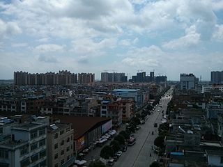
Yuhuan is a county-level city of Taizhou, at the midsection along the coast of southeastern Zhejiang Province, China. Yuhuan, with total area of 2,279 km2 (880 sq mi) including land area of 378 km2 (146 sq mi), has a total population of 392,800 containing a permanent population of 93,000 from other provinces and regions.

<span class="mw-page-title-main">Binyang County</span> County in Guangxi, China

Binyang County is a county of Guangxi Zhuang Autonomous Region, China, it is under the administration of the prefecture-level city of Nanning, the capital of Guangxi, with a permanent population of 782,255 and a hukou population of 1,051,373 as of the 2010 Census. It borders the prefecture-level cities of Laibin to the northeast and Guigang to the east. The main highways passing near the county seat are China National Highways 322 and 324. The local economy is based mostly on industry and services. The county seat is Binzhou Town, known as one of the oldest towns in Guangxi which has population over 200,000 people. People speak Binyanghua in Binyang, which is a branch of Cantonese.

<span class="mw-page-title-main">Yuanyang County, Henan</span> County in Henan, Peoples Republic of China

Yuanyang County is a county under the administration of the prefecture-level city of Xinxiang, in the north of Henan province, China.

<span class="mw-page-title-main">Wenling</span> County-level city in Zhejiang, Peoples Republic of China

Wenling is a coastal county-level city in the municipal region of Taizhou, in southeastern Zhejiang province, China. It borders Luqiao and Huangyan to the north, Yuhuan to the south, Yueqing to the west, looks out to the East China Sea to the east. Wenling locates on 28°22'N, 121°21'E, approximately 300 km (190 mi) south of Shanghai.

Xintian County is a county of Hunan Province, China, it is under the administration of the prefecture-level city of Yongzhou.

<span class="mw-page-title-main">Shuangfeng County</span> County in Hunan, Peoples Republic of China

Shuangfeng County is a county in Hunan Province, China, it is under the administration of Loudi prefecture-level City.

<span class="mw-page-title-main">China National Highway 228</span> Road in China

China National Highway 228 (228国道) is a planned highway of the National Highway System of the People's Republic of China to run from Dandong, Liaoning on the China–North Korea border to Dongxing, Guangxi on the China–Vietnam border.

Chumen is a town under the jurisdiction of Yuhuan, Taizhou, Zhejiang province, China. It is the hometown of China's pomelo. Chumen is situated in the north of Yuhuan and in the heart of the peninsula. Chumen's area is 37.5km2 (14.5mi²) and as of 2018 there are 18 villages and 3 residential committees under its authority.

<span class="mw-page-title-main">Longgang, Zhejiang</span> County-level city in Zhejiang, Peoples Republic of China

Longgang is a county-level city of Zhejiang, China. As of 2018, its population was 378,000, spread across 183.99 km2 (71.04 sq mi) divided into 14 neighborhoods, 22 residential areas, and 171 villages. Longgang is administered as a part of the prefecture-level city of Wenzhou, whose downtown is about 70 kilometers (43 mi) away.

<span class="mw-page-title-main">Taizhou Rail Transit</span> Metro system in Taizhou, Zhejiang, China

Taizhou Rail Transit is an urban rail transit system in Taizhou, Zhejiang Province, China. The system is operated by Taizhou Rail Transit Construction and Development Co., Ltd. In the near term, two lines, S1 and S2, are planned; in the long term, lines S3 and S4 are planned. The first phase of the plan was approved by the National Development and Reform Commission of the People's Republic of China in December 2014, and approved by the Zhejiang Provincial Development and Reform Commission in September 2016. Construction of Line S1 started in November 2016 and lasted until opening in December 2022.

Yuhuan railway station is a planned railway station in Yuhuan, Taizhou, Zhejiang, China. It will be the southern terminus of the Hangzhou–Taizhou high-speed railway. The station is expected to start construction in March 2022 and open in September 2025 with the Wenling-Yuhuan section of Hangzhou-Taizhou high-speed railway.

<span class="mw-page-title-main">Archives of Yuhuan</span> Archives of Yuhuan, in Taizhou, Province of Zhejiang, China

The Archives of Yuhuan is a municipal archive located in Yuhuan, city of Taizhou, in Zhejiang Province, China, established in July,1980. The current building was built in October 1984, with an area of 699 square meters, of which 422 square meters is the area of the library. Until June 2018, the collection of archives had 155 full files, more than 70,000 volumes, and 12,933 books in the collection. The new building of the archive is located on the side of Xuanmenwan Sanqiao, Shugang Avenue, Yuhuan Economic Development Zone; the old building has been closed and is located in Yucheng Subdistrict. The museum has achieved the honor of "Model County for Archives in the Construction of National Socialism's New Rural Areas" for Yuhuan, and it is the seventh in Zhejiang Province and the first in Taizhou City to be designed as, "First Grade Standard Archive in Zhejiang Province".

<span class="mw-page-title-main">Taizhou Museum</span> City museum in Taizhou, Zhejiang, Peoples Republic of China.

The Taizhou Museum, also known as Taizhou City Museum, abbreviated as Tai Bo, is a comprehensive municipal museum in Taizhou City, Zhejiang Province, China. It had a trial opening on July 1, 2016, and officially opened on July 12. The museum is located at 168 Aihua Road, Jiaojiang District, Taizhou City, and is divided into four levels. The permanent exhibitions include 'Shanhun Haipo' (山魂海魄) showcasing Taizhou's historical and cultural heritage, and 'Dadi Qinghuai' (大地情怀) focusing on Taizhou's folk culture.

<span class="mw-page-title-main">Yucheng Subdistrict, Yuhuan</span> Subdistrict under the jurisdiction of Yuhuan, Zhejiang Province, Peoples Republic of China.

Yucheng Subdistrict, formerly known as Chengguan Town (城关镇), is a sub-district office under the jurisdiction of Yuhuan, Zhejiang Province, People's Republic of China. It is the location of the Yuhuan City Government and serves as the city center of Yuhuan. Yucheng Subdistrict is situated to the east of Xuanmen Bay, bordered to the south by Kanmen Subdistrict and Damaiyu Subdistrict, adjacent to Lupu Town to the north, and surrounded by Leqing Bay to the west.

<span class="mw-page-title-main">Taizhou Library</span> National first-grade library in Taizhou, Zhejiang, China.

The Taizhou City Library, also known as Taizhou Library (台州图书馆), abbreviated as Tai Tu (台图), is a municipal-level public library located in Taizhou, Zhejiang, People's Republic of China. It is supervised by the Taizhou Municipal Bureau of Culture, Radio, Television, Tourism, and Sports, and is an affiliated unit of the latter. The library building is situated at 168 Hexie Road, Jiaojiang (Taizhou). As of 2019, the total collection of documents in the library reached 876,774 volumes, making it a nationally recognized first-grade library evaluated by the Ministry of Culture and Tourism.

<span class="mw-page-title-main">Yuhuan Library</span> National first-grade library in Yuhuan, Zhejiang, China.

Yuhuan City Library is a county-level public library located in Yuhuan, Zhejiang Province, China, established in August 1978. The old location is at Guangling Road No. 69, Yucheng, Yuhuan, while the new library located in the South Zone of Yuhuan Economic Development Zone is under construction. As of the end of 2016, the total collection of the Yuhuan Library exceeds 300,000 volumes. Currently, Yuhuan City Library is managed by the Bureau of Culture, Radio, Film, Television, Press, and Publication of Yuhuan and is designated as a national first-grade library by the Ministry of Culture and Tourism.

<span class="mw-page-title-main">Damaiyu Subdistrict</span> Subdistrict under the jurisdiction of Yuhuan, Zhejiang Province, Peoples Republic of China.

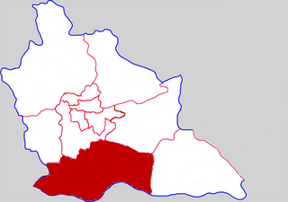
Damaiyu Subdistrict is a subdistrict office under the jurisdiction of Yuhuan City, Zhejiang Province, People's Republic of China. Its predecessor was Chenyu Town (陈屿镇). It covers a land area of 70.93 square kilometers and administers 6 communities and 48 administrative villages. According to the 2017 census, Damaiyu Subdistrict has a registered population of 56,476 people, with an additional approximate 41,000 registered non-local population. The subdistrict government office is located at No. 516 Xinggang West Road. Within its territory lies the national first-class port, the Damaiyu Port. In 1994, entrepreneurs Su Zengfu and Su Xianze registered and established Supor, which has since become China's largest and the world's second-largest cookware production enterprise.

<span class="mw-page-title-main">Lupu, Yuhuan</span> Town of Yuhuan City, Province of Zhejiang, Peoples Republic of China

Lupu is a town under the jurisdiction of Yuhuan County, Taizhou City, Zhejiang Province, People's Republic of China.

<span class="mw-page-title-main">Yuhuan Economic Development Zone</span> Township of Yuhuan City, Province of Zhejiang, Peoples Republic of China

Zhejiang Yuhuan Economic Development Zone, also known as Yuhuan New Town (玉环新城), formerly known as Zhejiang Damaiyu Economic Development Zone (浙江大麦屿经济开发区), was originally the Damaiyu Taiwan Trade Zone (大麦屿对台贸易区), established in June 1992. It is a provincial-level economic and technological development zone located in Yuhuan City, Zhejiang Province, with jurisdiction over Damaiyu Port, Xuanmen Phase II, and Xuanmen Phase III. Within the administrative region of Yuhuan City, the jurisdiction is akin to a township-level unit.

<span class="mw-page-title-main">Qinggang, Zhejiang</span> Town in Yuhuan, Zhejiang, Peoples Republic of China

Qinggang is a town under the jurisdiction of the city of Yuhuan, prefecture of Taizhou, Zhejiang Province, People's Republic of China.

References

  1. 王敬 刘腾 李辛 吴晓红、胡存超/摄 (2019-03-30). "大陆首个!台湾高校实训教学中心落户玉环沙门" (in Chinese). Archived from the original on 2019-03-30.
  2. 1 2 3 4 5 6 7 8 9 10 11 尚清, 主编; 中华人民共和国民政部; 黄惠君, 撰稿 (2015). "沙门镇" [Shamen Town]. 中华人民共和国政区大典 浙江省卷 (in Chinese). Beijing: 中国社会出版社. pp. 1898–1899. ISBN   978-7-5087-4991-4.
  3. 1 2 3 4 5 6 浙江省玉环县地名办, 编. 玉环县地名志:第二编:行政区划及居民点 桐丽乡 (in Chinese). Archived from the original on 2019-08-19.
  4. 玉环市门户网站-中国玉环 (2018-09-17). "沙门镇新一届班子成员分工及联系一览表" (in Chinese). Archived from the original on 2019-01-29. Retrieved 2019-01-20.
  5. 玉环县土地志编纂委员会, 编 (2000). 玉环县土地志:第一章土地环境 第二节地貌 海积平原 (in Chinese). Beijing: 中华书局. ISBN   7-101-02501-3. Archived from the original on 2019-08-28. Retrieved 2019-02-04.
  6. 1 2 3 浙江省玉环县编史修志委员会 (1994). 玉环县志:第一编 建置 第二节 建制镇 (in Chinese). 汉语大词典出版社. ISBN   7543201119. Archived from the original on 2019-08-23. Retrieved 2019-01-29.
  7. "NASA Earth Observations Data Set Index". NASA. Archived from the original on 2016-02-03. Retrieved 30 January 2016.
  8. "NASA Earth Observations: Rainfall (1 month - TRMM)". NASA/Tropical Rainfall Monitoring Mission. Archived from the original on 2016-04-12. Retrieved 2016-01-30.
  9. 玉环市教育局 (2017-06-05). "玉教〔2017〕36号__玉环市教育局关于做好部分学校校名更改的通知". 中国玉环 (in Chinese). Archived from the original on 2019-08-22. Retrieved 2019-03-15.
  10. 1 2 3 4 5 6 7 台州市统计局 (2018-12-17). "2018年台州统计年鉴:十八、乡镇经济社会基本情况(2017年)". 台州市统计信息网 (in Chinese). Archived from the original on 2019-04-14. Retrieved 2019-01-20.
  11. "今天!乐清湾大桥通车!玉环到乐清车程从3小时缩减至20分钟!". 台州发布 (in Chinese). 2018-09-28. Archived from the original on 2021-07-31.
  12. 董西青 (2017-02-24). "沙门全力以赴美化S226省道沙门段沿线环境 整治过后处处皆风景". 今日玉环 (in Chinese). Archived from the original on 2019-01-29.
  13. 1 2 董西青 (2017-03-31). "沙门:建设滨港工业城". 中国青年网 (in Chinese). Archived from the original on 2019-01-29.
  14. 玉环县交通志编纂委员会, 编 (1993). 玉环县交通志:三 公路 (二)县道 (in Chinese). 华艺出版社. Archived from the original on 2019-08-24. Retrieved 2019-02-03.
  15. 陈盼希. "玉环沙门兴安客运中心正式启用". 中国玉环新闻网 (in Chinese). Archived from the original on 2019-02-04. Retrieved 2018-05-28.
  16. 浙江旅游 (2018-10-10). "杭州3.5小时直达!来"浙江鼓浪屿"看海景吃海鲜了". 浙江在线·浙江新闻 (in Chinese). Archived from the original on 2019-01-29. Retrieved 2019-01-27.
  17. 1 2 3 玉环县, 地方志办公室 (2015). 玉环胜迹图志 (in Chinese) (1st ed.). Beijing: 方志出版社. p. 204. ISBN   9787514416329. OCLC   922449971. Archived from the original on 2018-12-02. Retrieved 2019-01-27.
  18. 张莺莺 金榆也 胡存超 (2018-11-16). "今年前三季度"成绩单"出炉 沙门多项工业经济指标"领跑"玉环". 玉环市门户网站-中国玉环 (in Chinese). Archived from the original on 2019-02-04.
  19. 戴守斌 (2010). "道路滨河绿化带景观设计——以玉环县滨港工业城为例". 绿色科技 (in Chinese) (7). Archived from the original on 2019-01-29. Retrieved 2019-01-29.
  20. 应挺刚 刘斌辉 (2017-12-07). "沙门滨港工业城建设创出新模式". 浙江新闻客户端 (in Chinese). Archived from the original on 2019-01-29.
  21. 徐旭升 (2017-02-07). "我县又有两处文保单位晋升为省保单位". 玉环市人民政府 (in Chinese). Archived from the original on 2018-11-18. Retrieved 2018-11-18.
  22. 吴达夫 (2013-08-25). 余彩虹 (ed.). "探寻与发现:横跨温岭玉环两地的"平环桥"". 台州晚报 (in Chinese). Archived from the original on 2018-11-18.
  23. 浙江省玉环县民政局, 编 (1995). 玉环县民政志:第二章行政区划 第一节隶属沿革 三、解放后区划 一、镇 (in Chinese). Hangzhou: 浙江人民出版社.
  24. 玉环县土地志编纂委员会, 编 (2000). 玉环县土地志:第四章人口耕地 第一节人口 (in Chinese). Beijing: 中华书局. ISBN   7-101-02501-3. Archived from the original on 2019-08-19. Retrieved 2019-02-04.
  25. 中华人民共和国统计局 (2000). "浙江省乡、镇、街道人口(中华人民共和国第五次全国人口普查数据)" (in Chinese). Archived from the original on 2017-11-12. Retrieved 2019-01-29.
  26. "中国2010年人口普查分乡、镇、街道资料》xls (China 2010 census)". Baidu.com (in Chinese). Archived from the original on 2021-11-09. Retrieved 2019-04-23.
  27. 中国玉环新闻网 (2014-11-13). "民风民俗—中国玉环新闻网" (in Chinese). Archived from the original on 2019-01-29. Retrieved 2019-01-29.
  28. 1 2 "镇乡名片-沙门". 中国玉环新闻网 (in Chinese). 2014-11-13. Archived from the original on 2016-08-08.