
Trail Ridge Road is the name for a stretch of U.S. Highway 34 that traverses Rocky Mountain National Park from Estes Park, Colorado in the east to Grand Lake, Colorado in the west. The road is also known as Trail Ridge Road/Beaver Meadow National Scenic Byway.

The Montrose Park is a public park, owned by the federal government, located in the 3000 block of R Street, Northwest, Washington, D.C., in the Georgetown neighborhood. It is located between Dumbarton Oaks Park, and Oak Hill Cemetery. Both Montrose Park and Dumbarton Oaks Park were jointly listed on the National Register of Historic Places on May 28, 1967. Montrose Park obtained an individual listing on 2007. In addition to a large children's play area in the back of the park, there are two sets of tennis courts, as well as open space with footwalks and trails which lead into Rock Creek Park.

This is a list of properties and historic districts in Oregon that are listed on the National Register of Historic Places. There are listings in all of Oregon's 36 counties.

This is a list of properties and historic districts in Iowa that are listed on the National Register of Historic Places. There are listings in all of Iowa's 99 counties, adding up to over 2,300 total.

There are more than 1,500 properties and historic districts in Colorado listed on the National Register of Historic Places. They are distributed over 63 of Colorado's 64 counties; only Broomfield County has none.

This is a list of structures, sites, districts, and objects on the National Register of Historic Places in North Carolina:

This is a list of properties and districts listed on the National Register of Historic Places in New Jersey. There are more than 1,700 listed sites in New Jersey. All 21 counties in New Jersey have listings on the National Register.

There are 445 properties and historic districts listed on the National Register of Historic Places in North Dakota. There are listings in 52 of North Dakota's 53 counties.
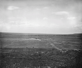
Fort Garland (1858–1883), Colorado, United States, was designed to house two companies of soldiers to protect settlers in the San Luis Valley, then in the Territory of New Mexico. It was named for General John Garland, commander of the Military District of New Mexico.

The Gunnison Tunnel is an irrigation tunnel constructed between 1905 and 1909 by the U.S. Bureau of Reclamation in Montrose County, Colorado. The 5.8 mile long tunnel diverts water from the Gunnison River to the arid Uncompahgre Valley around Montrose, Colorado.

Montrose, also known as Sibley City, is an unincorporated community in Baldwin County, Alabama, United States along the eastern shore of Mobile Bay.
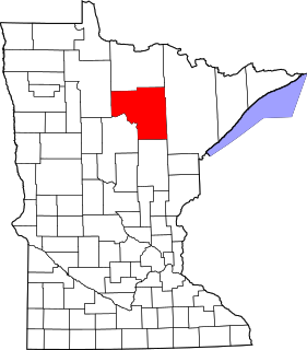
This is a list of the National Register of Historic Places listings in Itasca County, Minnesota. It is intended to be a complete list of the properties and districts on the National Register of Historic Places in Itasca County, Minnesota, United States. The locations of National Register properties and districts for which the latitude and longitude coordinates are included below, may be seen in an online map.

This is a list of the National Register of Historic Places listings in Wabasha County, Minnesota. It is intended to be a complete list of the properties and districts on the National Register of Historic Places in Wabasha County, Minnesota, United States. The locations of National Register properties and districts for which the latitude and longitude coordinates are included below, may be seen in an online map.

This is a list of the National Register of Historic Places listings in Montrose County, Colorado.
This is a list of the National Register of Historic Places listings in Cuyahoga Valley National Park.

Cañon Pintado, meaning painted canyon, is an archaeological site of Native American rock art located in the East Four Mile Draw, 10.5 miles (16.9 km) south of Rangely in Rio Blanco County, Colorado. Led by Ute guides, the Dominguez-Escalante Expedition, Spanish missionaries in search of a route to California in 1776, passed through this region as they moved north and then west into Utah. The first Europeans to the area, they named it Cañon Pintado, meaning "painted canyon".

Santa Rosa de Lima was an early 18th-century Spanish settlement in the Rio Chama valley, near the present-day town of Abiquiu in Rio Arriba County, New Mexico. By the 1730s Spanish settlers were moving into the Chama River valley, and by 1744 at least 20 families were living in the present-day Abiquiú area, where they founded the Plaza de Santa Rosa de Lima. The church was built around 1744, and was in use until the 1930s. Repeated raids by Utes and Comanches caused the settlement to be abandoned in 1747. In 1750, the Spanish founded a new settlement at the present site of Abiquiú, about a mile from Santa Rosa de Lima.


