Related Research Articles

Kasaragod is a municipal town and administrative headquarters of Kasaragod district in the state of Kerala, India. Established in 1966, Kasaragod was the first municipal town in the district. It is the northernmost district of Kerala and is also known as Sapta Bhasha Sangama Bhumi.
Kannur is one of the 14 districts along the west coast in the state of Kerala, India. The city of Kannur is the district headquarters and gives the district its name. The old name, Cannanore, is the anglicized form of the Malayalam name "Kannur". Kannur district is bounded by Kasaragod District to the north, Kozhikode district to the south, Mahé district to the southwest and Wayanad District to the southeast. To the east, the district is bounded by the Western Ghats, which forms the border with the state of Karnataka. The Arabian Sea lies to the west. Paithalmala is the highest point in Kannur District (1,372m). Enclosed within the southern part of the district is the Mahé district of the Union Territory of Puducherry. The district was established in 1957.

The Chandragiri River or Payaswini also known as the Perumpuzha River, is the longest river in Kasaragod district, Kerala, India. The River Is A Historical Treasure Of Chemnad. It was named after the Mauryan emperor Chandragupta Maurya.

Kumbla is a small town in Kasaragod district of Kerala state in India. It is located 12 km north of Kasaragod town.

Uppala is a town and Headquarters of Manjeshwaram Taluk in Kasaragod district, Kerala, India. It is geographically located midway from Kasaragod to Mangalore. Easy geographical access and lack of major towns nearby are the key reasons for the town to develop exponentially, especially in the past decade. The population of Manjeshwaram Taluk alone was over 268,642 as of 2011. Uppala is 22 km north of Kasaragod and one of the fastest growing urban settlements in Kasaragod district. It is well known as an important trade hub in the northernmost part of Kerala state.

Kasaragod is one of the 14 districts in the southern Indian state of Kerala. Its northern border Thalappady is located just 9 km south to Ullal, which is the southernmost portion of the major port city Mangalore, on the southwestern Malabar coast of India.

Cherupuzha is a town in Kannur district, Kerala, India. It is the headquarters of the Cherupuzha Panchayat which is a special grade panchayat in Kerala.

Badiyadka officially known as "Badiadka" is a town and gram panchayat in the Kasaragod district, state of Kerala, India.
Mangalpady is a Grama Panchayat in Kasaragod district, Kerala. Uppala is the major town in this panchayat.
Shiriya is a village in the Kasaragod district of Kerala, India. Shiriya is composed of several smaller villages, those being Shiriya, Shiriya kunnil, Muttam-gate, and Olayam.
Mogral Puthur is a gram panchayat in the Kasaragod District, state of Kerala, India. It is north of the town of Kasaragod, and it consists of two revenue villages. The village of Puthur is the northern portion of the roughly circular panchayat, and Kudlu encompasses the southern half. Mogral Puthur has on its west border the Arabian Sea; on the east is the Madhur panchayat; and on the north is the Mogral River. The total area of this "second-grade" panchayat is 14.23 square kilometers. The major business centers are: Puthur, Chowki, Padinhar and Eriyal.
Pallathadka is a hamlet in the Badiyadka village of Kasaragod district, Kerala State of India.

Manjeshwaram taluk is the northern most taluk of Kerala which borders Karnataka state. It is located in Kasaragod district, Kerala which was carved out from Kasaragod taluk on 2013.

Perla is an administrative capital of Enmakaje Panchayat, which is in Kasaragod district, Kerala, India.
Kasaragod North is a suburb of Kasaragod city in north Kerala. It is located at the mouth of a lagoon formed by the Shiriya river. The following townships, suburbs and villages are part of Kasaragod North:

Kasaragod District is the northernmost district in the southwestern Indian coastal state of Kerala. The district has a long history starting from pre-historic times to the modern period.

Mulleria is a small town located in Karadka Panchayath, Kasaragod district in Kerala, India.
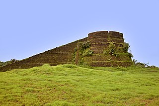
Arikadi Fort is a fort located in the Kasaragod district of Kerala, India. It is also known as Kumbla Fort. The fort is located at a distance of 2 km from Kumbla on the NH 66 National Highway between kumbala River and shiriya River There is a Hanuman temple just below the fort.
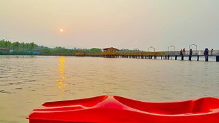
Uppala River flows through the states of Karnataka and Kerala. Uppala River is 50 km long, making it the 26th longest river in Kerala. It originates from the Veerakamba hills in Dakshina Kannada district in Karnataka at an elevation of 150 metres above sea level, flows primarily in a westward direction, and empties into the Arabian Sea in the backwaters near the town of Uppala located about 22 km north of Kasaragod town in Kerala. The river has a catchment area of 250 km2 of which 174 km2 is in Karnataka state.
Bela is a village in Kasaragod taluk of Kasaragod district in Indian state of Kerala.
References
- 1 2 3 4 "Shiriya River and Yelkanna River, Reconnaissance Survey Report" (PDF). Tropical Institute of Ecological Sciences (TIES), Kerala. December 2017. Retrieved 2021-05-14.
- ↑ "District Census Handbook - Kasaragod District 2011" (PDF). Directorate of Census Operations-Kerala. 2011-10-01. Retrieved 2021-05-14.
- ↑ "About the Rivers of Kerala" . Retrieved 2021-05-14.