
Cantua Creek is a census-designated place (CDP) in Fresno County, California, United States. As of the 2010 census, the population was 466, down from the 655 reported at the 2000 census. Cantua Creek is located 11 miles (18 km) south-southwest of Tranquillity, at an elevation of 295 feet.

Charter Oak is an unincorporated community and census-designated place (CDP) in Los Angeles County, California, approximately 26 miles (42 km) east of downtown Los Angeles. The population was 9,310 at the 2010 census, up from 9,027 at the 2000 census.
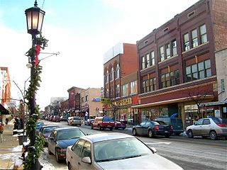
Cambridge (kaym-brij) is a city in and the county seat of Guernsey County, Ohio, United States. It lies in southeastern Ohio, in the Appalachian Plateau of the Appalachian Mountains about 75 miles (121 km) east of Columbus and approximately 124 miles (200 km) south of Cleveland. The population was 10,089 at the 2020 census. It is the principal city of the Cambridge micropolitan area and is located adjacent to the intersection of Interstates 70 and 77.

Turtle Creek is a borough in Allegheny County, Pennsylvania, United States, 12 miles (19 km) southeast of Pittsburgh. The population was 5,114 at the 2020 census. George Westinghouse constructed a manufacturing plant nearby. Turtle Creek takes its name from a small stream that flows into the Monongahela River. Before white settlers arrived, there was a small village of Native Americans living there from the Turtle Clan of the Iroquois Nation.

Clarksville is a borough in Greene County, Pennsylvania, United States. The population was 194 at the 2020 census.
Wyldwood is a census-designated place (CDP) in Bastrop County, Texas, United States. The population was 3,694 at the 2020 census.

Salado is a village in Bell County, Texas, United States. Salado was first incorporated in 1867 for the sole purpose of building a bridge across Salado Creek. In 2000, the citizens of Salado voted in favor of reincorporation, before which it was a census-designated place. The population was 2,394 at the 2020 census.

Lipscomb is an unincorporated community and census-designated place (CDP) in Lipscomb County, Texas, United States. It is the county seat of Lipscomb County. The population was 66 at the 2020 census.
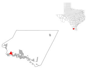
Roma Creek is a former census-designated place (CDP) in Starr County, Texas, United States. The population was 350 at the 2010 census down from 610 at the 2000 census.

Grape Creek is a census-designated place (CDP) in Tom Green County, Texas, United States. It is part of the San Angelo, Texas Metropolitan Statistical Area. The population of Grape Creek was 3,154 at the 2010 census.

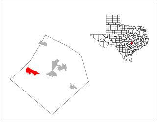
Barton Creek is a census-designated place (CDP) in Travis County, Texas, United States. As of the 2020 census, the CDP population was 3,356.

Lost Creek is an affluent upper-middle-class neighborhood and census-designated place (CDP) in Travis County, Texas, United States. The population was 1,276 at the 2020 census. The census tract is bordered by Capital of Texas Highway to the east, Barton Creek to the south, Barton Creek Boulevard to the west, and Bee Caves Road to the north. The Lost Creek CDP encompasses several small neighborhoods—Parkstone, Woods of Westlake, Camelot, and Knollwood—as well as the largest and most populous Lost Creek neighborhood.

McDonald is a borough in Allegheny and Washington counties in the U.S. state of Pennsylvania, 18 miles (29 km) southwest of Pittsburgh. The population was 2,056 at the 2020 census. Of this, 1,661 were in Washington County, and 395 were in Allegheny County.

Falls Creek is a borough located in Jefferson County, Pennsylvania, United States. The population was 1,036 at the 2020 census.
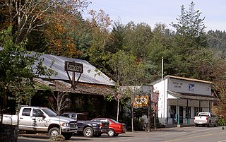
Cazadero is an unincorporated community and census-designated place (CDP) in western Sonoma County, California, United States with a population of 354 in 2010. The downtown of Cazadero consists of two churches, a general store, a post office, a hardware store, an auto repair garage, private office space, and the Cazadero Volunteer Fire Department.
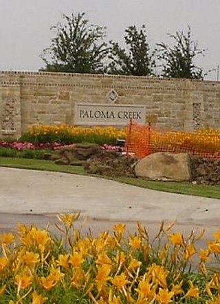
Paloma Creek is a master-planned community in northeastern Denton County, Texas, United States. The community is listed by the U.S. Census Bureau as two separate census-designated places, "Paloma Creek" and "Paloma Creek South", separated by U.S. Highway 380. As of the 2010 census, the Paloma Creek CDP had a population of 2,501, while Paloma Creek South had a population of 2,753. As of 2022, the HOA currently estimates the population to be approximately 20,000.

Foresta is an unincorporated community and a census-designated place (CDP) in Mariposa County, California, within Yosemite National Park.
Bear Creek is a census-designated place in Merced County, California. It is located 3.5 miles (5.6 km) east of Merced, at an elevation of 190 feet. The population was 273 at the 2020 United States census, down from 290 at the 2010 census.
Paloma Creek South is a census-designated place (CDP) in eastern Denton County, Texas, United States. It is part of the Paloma Creek master-planned community. As of the 2010 census, Paloma Creek South had a population of 2,753.
Bear Creek Ranch is a planned community and census-designated place (CDP) in Dallas County, Texas, United States. It was first listed as a CDP in the 2020 census with a population of 1,787.

