South Pasadena Local

Last updated

South Pasadena Local
South Pasadena Daly Street Bridge.jpg
Pacific Electric passenger rail car no.212 passes over the Daly Street Bridge, c.1906
Overview
Owner Southern Pacific Railroad
Locale Southern California
Termini
Stations7
Service
Type Light rail
System Pacific Electric
Operator(s) Pacific Electric
Rolling stock600 Class (1928–1938)
Birney 300 Class (1938–1942)
History
OpenedMay 7, 1895
ClosedOctober 17, 1942 (1942-10-17)
Technical
Track gauge 1,435 mm (4 ft 8+12 in) standard gauge
Old gauge3 ft 6 in (1,067 mm)
Electrification 600  V   DC Overhead lines
Route map

Contents

BSicon uCONTg@Gq.svg
BSicon ulBHF.svg
BSicon ueABZq+r.svg
BSicon uCONTfq.svg
South Pasadena
BSicon uexHST.svg
Meridian Street
BSicon CONTgq.svg
BSicon uxmKRZ.svg
BSicon CONTfq.svg
BSicon uexHST.svg
Ostrich Farm
BSicon uexHST.svg
Mineral Park
BSicon uexhbKRZWae.svg
BSicon uexCONTgq.svg
BSicon uexABZg+r.svg
BSicon uexHST.svg
Avenue 64
BSicon CONTgq.svg
BSicon uxmKRZ.svg
BSicon CONTfq.svg
BSicon uexHST.svg
Garvanza
BSicon uexbWBRUCKE1.svg
BSicon undCONTg@Gq.svg
BSicon unSTRq.svg
BSicon uexSTR.svg
BSicon undCONTf@Fq.svg
  9  
BSicon undCONTg@Gq.svg
BSicon unSTRq.svg
BSicon uexSTR.svg
BSicon undCONTf@Fq.svg
  O  
BSicon CONTgq.svg
BSicon uxmhKRZa.svg
BSicon CONTfq.svg
BSicon uhKBHFxa.svg
General Hospital
terminus
after 1935
BSicon lhSTRe@g.svg
BSicon uABZg+l.svg
BSicon uCONTfq.svg
multiple lines
BSicon uHST.svg
Echandia
BSicon uDST.svg
Macy Carhouse
BSicon unCONTgq.svg
BSicon MSTRq.svg
BSicon lhSTRaeq.svg
BSicon unSTRq.svg
BSicon uSTR.svg
BSicon unCONTfq.svg
Brooklyn Avenue   B  
BSicon CONTgq.svg
BSicon umhKRZa.svg
BSicon CONTfq.svg
BSicon dWASSERq.svg
BSicon uhKRZW.svg
BSicon dWASSERq.svg
BSicon CONTgq.svg
BSicon umhKRZe.svg
BSicon CONTfq.svg
BSicon unCONTgq.svg
BSicon uKRZn.svg
BSicon unCONTfq.svg
  P  
BSicon uCONTgq.svg
BSicon uKRZ.svg
BSicon uCONTfq.svg
BSicon lhSTRa@f.svg
BSicon uABZg+l.svg
BSicon uCONTfq.svg
Southern Division
BSicon uhKINTe.svg
6th/Main Terminal
  F  
multiple lines
 

South Pasadena Local was a local streetcar line operated by the Pacific Electric Railway between Downtown Los Angeles and South Pasadena, California by way of the Arroyo Seco Route. This was one of four lines that connected the two cities.

Route

The South Pasadena Line originated at the Pacific Electric Building in downtown Los Angeles. The double-track railway exited the station on to Main Street and ran in the pavement of city streets: north on Main Street, east on 1st Street, north on Los Angeles Street and east on Aliso Street to the Los Angeles River. The line crossed the river and Mission Road on the Aliso Street Viaduct and ran east in a private right of way (that by 1981 had been obliterated by construction of the San Bernardino Freeway) to Echandia Junction. It then turned north, crossing Mission Road and over the Southern Pacific Railroad Mainline. It then turned east and proceeded in a private right of way along the route of the Golden State Freeway to Daly Street, where the line returned to street running. It then continued north on Daly Street and Pasadena Avenue and then ran northeast on Figueroa Street (as far as York Boulevard on private way, presently York Boulevard and Pasadena Avenue) It crossed the Arroyo Seco on the Garvanza Viaduct and then proceeded to Mission Street. The line continued east in the pavement of Mission Street to reach its terminus at Fair Oaks Avenue.

History

This line was opened on May 7, 1895 by the Pasadena and Los Angeles Railway with narrow gauge rails. [1] The line was rebuilt as standard gauge in 1903 after it was acquired by Pacific Electric, though construction of the Pasadena Short Line relegated the South Pasadena Local to a secondary status. [2] Supplemental service on the north end of the line was provided by the Mission and Fair Oaks Avenue Local Line until 1911. Cars were through-routed with the Watts Line from 1912 to 1923. [3] Service was converted to one-man operation starting in 1931. Routing with the Watts Line began once again in 1932, and the segment of the line between General Hospital and South Pasadena was abandoned at the start of 1935 with cars still running as far at Watts. [3] Through-routing was reduced to shuttle service between the Hospital and Echandia in 1938, covering a distance of about 1,000 feet (300 m) (the shortest service offered by the railroad, though operating in an exclusive right of way). [3] A base headway service was largely maintained until October 17, 1942 when the shuttle was discontinued. [3]

List of major stations

StationMajor connectionsDate openedDate closedCity
South Pasadena Mount Lowe, Pasadena Short Line 19021951 South Pasadena
Echandia Junction Alhambra–San Gabriel, Annandale, Monrovia–Glendora, Mount Lowe, Pasadena Short Line, Pasadena via Oak Knoll, Pomona, Riverside-Rialto, Sierra Madre, Upland–San Bernardino 18951951 Los Angeles
Pacific Electric Building Alhambra–San Gabriel, Annandale, Balboa, Fullerton, Hawthorne-El Segundo, La Habra–Fullerton–Yorba Linda, Long Beach, Monrovia–Glendora, Mount Lowe, Pasadena Short Line, Pasadena via Oak Knoll, Pomona, Riverside–Rialto, San Pedro via Dominguez, San Pedro via Gardena, Santa Ana, Santa Monica Air Line, Sierra Madre, Soldiers' Home, Whittier 19051961

Rolling stock

Hollywood Cars began operations over the line in 1928. [4] Shuttle operations in 1938 were handled by a single Birney 300 Class.

Related Research Articles

<span class="mw-page-title-main">Pacific Electric</span> Southern California transit company

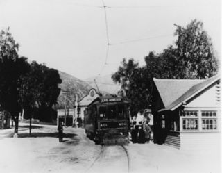
The Pacific Electric Railway Company, nicknamed the Red Cars, was a privately owned mass transit system in Southern California consisting of electrically powered streetcars, interurban cars, and buses and was the largest electric railway system in the world in the 1920s. Organized around the city centers of Los Angeles and San Bernardino, it connected cities in Los Angeles County, Orange County, San Bernardino County and Riverside County.

<span class="mw-page-title-main">Arroyo Seco Parkway</span> Highway in California

The Arroyo Seco Parkway, also known as the Pasadena Freeway, is one of the oldest freeways built in the United States. It connects Los Angeles with Pasadena alongside the Arroyo Seco seasonal river. It is notable not only for being an early freeway, mostly opened in 1940, but for representing the transitional phase between early parkways and modern freeways. It conformed to modern standards when it was built, but is now regarded as a narrow, outdated roadway. A 1953 extension brought the south end to the Four Level Interchange in downtown Los Angeles and a connection with the rest of the freeway system.

<span class="mw-page-title-main">Colorado Boulevard</span> Major east–west street in Los Angeles County, Southern California

Colorado Boulevard is a major east–west street in Southern California. It runs from Griffith Park in Los Angeles east through Glendale, the Eagle Rock section of Los Angeles, Pasadena, and Arcadia, ending in Monrovia. The full route was once various state highways but is now locally maintained in favor of the parallel Ventura Freeway and Foothill Freeway (I-210).

<span class="mw-page-title-main">Arroyo Seco (Los Angeles County)</span> Seasonal watercourse and human settlement in USA

The Arroyo Seco, meaning "dry stream" in Spanish, is a 24.9-mile-long (40.1 km) seasonal river, canyon, watershed, and cultural area in Los Angeles County, California. The area was explored by Gaspar de Portolà who named the stream Arroyo Seco as this canyon had the least water of any he had seen. During this exploration he met the Chief Hahamog-na (Hahamonga) of the Tongva Indians.
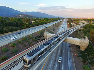
<span class="mw-page-title-main">L Line (Los Angeles Metro)</span> Los Angeles Metro Rail light rail line connecting Los Angeles and its suburb of Azusa

The L Line is a 31-mile (50 km) light rail line running from Azusa to East Los Angeles via Downtown Los Angeles serving several attractions, including Little Tokyo, Union Station, the Southwest Museum, Chinatown, and the shops of Old Pasadena. The line, one of seven in the Metro Rail system, entered service in 2003 and is operated by the Los Angeles County Metropolitan Transportation Authority (Metro). The L Line serves 26 stations.

<span class="mw-page-title-main">Garvanza, Los Angeles</span> Neighborhood of Los Angeles in California, United States

Garvanza is a neighborhood in northeast Los Angeles. Fourteen Los Angeles Historic-Cultural Monuments are located in the neighborhood.

The Annandale Line was an interurban route operated by the Pacific Electric Railway from 1902 to 1928.

<span class="mw-page-title-main">Monrovia–Glendora Line</span> Pacific Electric streetcar route (1902–1951)

The Monrovia–Glendora Line was a route on the Pacific Electric Railway serving the San Gabriel Valley. It operated from 1902 to 1951, supporting nearby real estate development.

<span class="mw-page-title-main">Sierra Madre Line</span>

The Sierra Madre Line was a Pacific Electric interurban route which ran 16.52 miles (26.59 km) from the Pacific Electric Building in Los Angeles to Sierra Madre.

<span class="mw-page-title-main">Upland–San Bernardino Line</span> Pacific Electric streetcar route (1914–1950)

The Upland–San Bernardino Line was an interurban line operated by the Pacific Electric Railway between Downtown Los Angeles and San Bernardino, California. This line also had shorter service that terminated before the end of the line at Baldwin Park, Covina, and San Dimas. Though service along this line in its entirety was discontinued in November 1941, it stands as the fourth-longest rapid transit line in American history, after the Sacramento Northern Chico and Colusa services, and the Pacific Electric's own Riverside–Rialto Line.

<span class="mw-page-title-main">South Hollywood–Sherman Line</span> Pacific Electric street car line (1896–1953)

The South Hollywood–Sherman Line was a suburban route of the Pacific Electric Railway. The line ran between Downtown Los Angeles and the suburb of Sherman. The line was named after Moses Sherman, who built the line and the Sherman street car yard on the line in West LA. The large 5.56-acre (2.25 ha) rail facility was on Santa Monica Boulevard just west of La Cienega Boulevard. The yard had a steam power house, a car barn and a shop building.

<span class="mw-page-title-main">Hollywood Line</span> Pacific Electric streetcar line (1909–1953)

The Hollywood Line was a local streetcar line of the Pacific Electric Railway. It primarily operated between Downtown Los Angeles and Hollywood, with some trips as far away as Beverly Hills and West Los Angeles. It was the company's busiest route prior to the opening of the Hollywood Subway. Designated as route 32, the line operated from 1909 until 1953.

<span class="mw-page-title-main">Long Beach Line</span> Pacific Electric interurban route in California

The Long Beach Line was a major interurban railway operated by the Pacific Electric Railway between Los Angeles and Long Beach, California via Florence, Watts, and Compton. Service began in 1902 and lasted until 1961, the last line of the system to be replaced by buses. However, the Southern Pacific Transportation Company continued to operate freight on the tracks, as the Union Pacific Railroad still does between Amoco and Dominguez Junction, and in 1990 the Southern California Rapid Transit District opened the Blue Line light rail along the same right-of-way.

<span class="mw-page-title-main">Sierra Vista Line</span> Pacific Electric streetcar line (1895–1951)

The Sierra Vista Line was a streetcar route mostly operated by the Pacific Electric Railway. It ran from 1895 to 1951 as the short turn making local stops along the Pasadena Short Line on the outside tracks of the Northern Division quadruple-track system.

J was a streetcar line in Los Angeles, California. It was operated by the Los Angeles Railway from 1911 to 1945, by Los Angeles Transit Lines from 1945 to 1958, and by the Los Angeles Metropolitan Transit Authority from 1958 to 1963.

<span class="mw-page-title-main">F (Los Angeles Railway)</span>

F was a streetcar line in Los Angeles, California. It was operated by the Los Angeles Railway from 1911 to 1955.

<span class="mw-page-title-main">W (Los Angeles Railway)</span>

W was a streetcar line in Los Angeles, California. It was operated by the Los Angeles Railway (LARy) from 1895 to 1956.

<span class="mw-page-title-main">Huntington Drive</span> United States street in Los Angeles

Huntington Drive is a major thoroughfare that begins in the Rose Hills community in Los Angeles, California and heads east/northeast to Irwindale, California. The street was named after railroad magnate Henry Huntington. It also served as one of the only thoroughfares between Los Angeles and Pasadena in the early 1900s. Portions of Huntington Drive were part of U.S. Route 66. The road has a wide median that was originally one of the lines of the Pacific Electric Railway.

<span class="mw-page-title-main">Cable cars in Los Angeles</span> Form of street railway extant 1885 to 1902

Cable car street railways first began operating in Los Angeles in 1885 and lasted until 1902, when the lines were electrified and electric streetcars were introduced largely following the cable car routes. There were roughly 25 miles (40 km) of routes, connecting 1st and Main in what was then the Los Angeles Central Business District as far as the communities known today as Lincoln Heights, Echo Park/Filipinotown, and the Pico-Union district.

<span class="mw-page-title-main">Venice Boulevard Line</span>

The Venice Boulevard Line was a local streetcar line of the Pacific Electric. It operated between Downtown Los Angeles and Vineyard Junction, where riders could transfer to interurban cars. Nearly all Venice Short Line cars did not accept local passengers, leaving this as the primary streetcar service along its namesake boulevard.

References

Definition of Free Cultural Works logo notext.svg  This article incorporates text from a free content work. Licensed under the public domain as a work of the State of California .( license statement/permission ). Text taken from 1981 Inventory of Pacific Electric Routes , California Department of Transportation , Los Angeles County Metropolitan Transportation Authority . To learn how to add open license text to Wikipedia articles, please see this how-to page. For information on reusing text from Wikipedia, please see the terms of use.

  1. "The New Line". The Los Angeles Times . May 7, 1895. p. 10. Retrieved December 11, 2022 via Newspapers.com. Lock-green.svg
  2. "South Pasadena Local Lines". Electric Railway Historical Association of Southern California. Retrieved February 13, 2021.
  3. 1 2 3 4 Veysey, Laurence R. (June 1958). A History Of The Rail Passenger Service Operated By The Pacific Electric Railway Company Since 1911 And By Its Successors Since 1953 (PDF). LACMTA (Report). Los Angeles, California: Interurbans. pp. 12, 13, 86, 138. ASIN   B0007F8D84. OCLC   6565577.
  4. "Modern cars to be placed in operation on South Pasadena line of Pacific Electric". Foothill Review. August 24, 1928. p. 8. Retrieved December 11, 2022 via Newspapers.com. Lock-green.svg