Fullerton Line

Last updated

Fullerton
PELogo.svg
Overview
Owner Southern Pacific Railroad
LocaleLos Angeles, the Gateway Cities and Orange County
Termini
Stations40
Service
Type Interurban
System Pacific Electric
Operator(s) Pacific Electric
Rolling stockPE 220 Class (last used)
Ridership100,105 (1926)
History
Opened1917
ClosedJanuary 22, 1938 (passenger)
c.1940s–1962 (freight)
Technical
Number of tracks1–4
Track gauge 4 ft 8+12 in (1,435 mm) standard gauge
Electrification 600 V DC Overhead lines
Route map

Contents

BSicon udCONTg.svg
BSicon uSTR.svg
  B    F    G    O  
 
BSicon undCONTg@Gq.svg
BSicon uINT.svg
BSicon unSTRq.svg
BSicon undCONTf@Fq.svg
Pacific Electric Building
Edendale Local
BSicon undCONTg@Gq.svg
BSicon uKRZn.svg
BSicon undCONTf@Fq.svg
  H    J    R    S  
BSicon undCONTg@Gq.svg
BSicon uABZgnr.svg
  B    F    G    O  
BSicon uABZg+l.svg
BSicon udCONTfq.svg
multiple
lines
BSicon undCONTg@Gq.svg
BSicon uKRZn.svg
BSicon undCONTf@Fq.svg
  U  
BSicon uBHF.svg
Amoco
BSicon udCONTgq.svg
BSicon uABZgr.svg
BSicon undCONTg@Gq.svg
BSicon lINT.svg
BSicon uKRZn.svg
BSicon undCONTf@Fq.svg
Vernon Avenue
  V  
BSicon uBHF.svg
Slauson Junction
BSicon udCONTgq.svg
BSicon uABZgr.svg
multiple
lines
BSicon uHST.svg
Dozier
BSicon undCONTg@Gq.svg
BSicon uHST.svg
BSicon unSTRq.svg
BSicon undCONTf@Fq.svg
Huntington Park
  J  
BSicon uHST.svg
Miles
BSicon uHST.svg
Fruitland
BSicon uHST.svg
Bell
BSicon uHST.svg
Greening
BSicon uHST.svg
Baker
BSicon uHST.svg
Walker
BSicon uhbKRZWae.svg
BSicon uHST.svg
Laguna
BSicon uHST.svg
Gage
BSicon uHST.svg
Rio Hondo
BSicon uhbKRZWae.svg
BSicon uHST.svg
McCampbell
BSicon uHST.svg
Downey Road
BSicon uHST.svg
Rivera
BSicon uHST.svg
Burke
BSicon uhbKRZWae.svg
BSicon uHST.svg
Guirado
BSicon dCONTgq.svg
BSicon umKRZ.svg
BSicon dCONTfq.svg
BSicon uBHF.svg
Los Nietos
BSicon uABZgl.svg
BSicon udCONTfq.svg
BSicon uHST.svg
Valla
BSicon uHST.svg
Hazzard
BSicon uHST.svg
Walnut Avenue
BSicon uHST.svg
Adams
BSicon uHST.svg
Bethel
BSicon uHST.svg
Colima
BSicon uHST.svg
Scott
BSicon uHST.svg
Leffingwell
BSicon uHST.svg
Toler
BSicon uHST.svg
Des Moines
BSicon uHST.svg
Leuhm
BSicon uBHF.svg
La Habra
BSicon uHST.svg
Loan Junction
BSicon uABZgl.svg
BSicon udCONTfq.svg
BSicon uHST.svg
Alta Mar
BSicon uHST.svg
North Bastanchury
BSicon uHST.svg
Bastanchury
BSicon uHST.svg
South Bastanchury
BSicon uHST.svg
Spadra Road
BSicon uHST.svg
Harvard Avenue
BSicon HUBa.svg
BSicon uKBHFe.svg
Fullerton
BSicon dCONTgq.svg
BSicon HUBe.svg
BSicon BHFq.svg
BSicon dCONTfq.svg
Fullerton
Santa Fe
BSicon TRAIN3.svg

The Fullerton Line was an interurban route of the Pacific Electric Railway. It ran between Downtown Los Angeles and Fullerton, California. It opened in 1917 and hosted passenger service until 1938; the line was retained for freight for some time thereafter. After abandonment, the right of way between La Habra and Fullerton was mostly converted to a rail trail or built over.

History

The line, among the electric railway's final expansions, [1] was not originally intended for passenger service unless a connection to Orange was completed. Despite this, the route was opened for service in 1917. [lower-alpha 1] [2] [3] Pacific Electric spent $425,000 on the extension from La Habra to Fullerton ($9.71 million in 2022 adjusted for inflation). [4]

The route was not a significant source of passenger traffic, but did generate revenue by hauling citrus fruit from the area. [4] PE reported losses on the line of $1,610 for travel in the year 1934 (equivalent to $35,220in 2022). [5] In September 1935, service was reduced to one daily shuttle trip running between Fullerton and Laon Junction, then the inbound trip reversing to Yorba Linda. [3] PE discontinued passenger service to Fullerton on January 22, 1938. [3] [6] [7] Landowners along the line petitioned for its total closure in 1939, [8] but freight traffic continued until the late 1940s or as late as about 1962. [4] [9]

One of the more prominent landmarks on the line was a concrete arch bridge over Harbor Boulevard that was emblazoned with a message welcoming visitors to Fullerton. [9] The bridge was razed in 1964 to ease clearances for trucks. [10]

Part of the former right of way became a section of the Juanita Cooke Greenbelt & Trail. [2] The Southeast Gateway Line light rail project is expected to use a section of the line between Slauson and the former Los Angeles and Salt Lake Railroad right of way. The right of way through Fullerton had been sold off and largely developed by 2023. [9]

Route

The Fullerton Line followed the Long Beach Line from Los Angeles south to Slauson Junction (south of Slauson Boulevard) where it branched off in an easterly direction to Whittier and Yorba Linda. From there, the double track line ran easterly, in private way between dual roadways of Randolph Street, through Huntington Park, Vernon, Bell, and Maywood to reach the Los Angeles River. Crossing the river, the double track in private way followed intermittent sections of Randolph Street through Bell Gardens and Commerce, and crossed the Rio Hondo south of Slauson Avenue.

The line continued easterly, south and parallel to, Slauson Avenue, across the Pico Rivera area and the San Gabriel River into Los Nietos, where the line crossed the Atchison, Topeka and Santa Fe Railway Third District main line (Los Nietos) at Norwalk Boulevard. The single track La Habra–Fullerton–Yorba Linda Line branched easterly in private way off the Whittier Line at Los Nietos, crossed Norwalk Boulevard and went through Whittier at the south edge of the city limits. After crossing Mills Avenue the track ran adjacent to and north of Lambert Road until crossing 1st Street. Here the line turned easterly through La Habra to Laon Junction (3rd Avenue at College Street), where the single track Fullerton Line branched to the south.

The track traversed the West Coyote Hills, crossing the Union Pacific line and an AT&SF spur before descending into Fullerton and crossing over Harbor Boulevard on a concrete arch bridge. [9] [11] The right of way then turned south to cut through the Fullerton College campus on what was called "Boxcar Avenue". [9] After crossing Commonwealth Avenue, the tracks swung around a small car yard to briefly run west on Santa Fe Avenue before arriving at the Fullerton depot. [12]

List of major stations

StationMajor connectionsDate openedDate closedCity
Pacific Electric Building Alhambra–San Gabriel, Annandale, Balboa, Hawthorne–El Segundo, La Habra–Yorba Linda, Long Beach, Monrovia–Glendora, Mount Lowe, Pasadena Short Line, Pasadena via Oak Knoll, Pomona, Redlands, Redondo Beach via Gardena, Riverside–Rialto, San Pedro via Dominguez, San Pedro via Gardena, Santa Ana, Santa Monica Air Line, Sierra Madre, Soldiers' Home, South Pasadena Local, Upland–San Bernardino, Whittier
Los Angeles Railway B, H, J, R, 7, and 8
19051961Los Angeles
Amoco[ dubious ] Balboa, Hawthorne–El Segundo, La Habra–Yorba Linda, Long Beach, Redondo Beach via Gardena, San Pedro via Dominguez, San Pedro via Gardena, Santa Ana, Santa Monica Air Line, Soldiers' Home, Whittier 19021961
Slauson Junction Balboa, Hawthorne–El Segundo, La Habra–Yorba Linda, Long Beach, Redondo Beach via Gardena, San Pedro via Dominguez, San Pedro via Gardena, Santa Ana, Whittier 19021961
Los Nietos La Habra–Yorba Linda, Whittier 19031941 Santa Fe Springs
La Habra La Habra–Yorba Linda 19111938 La Habra
Fullerton Atchison, Topeka, and Santa Fe Railroad 19171938 Fullerton

Notes

  1. Veysey gives two dates for the possible start of service: September 30 and December 7

Related Research Articles

<span class="mw-page-title-main">Venice Boulevard</span> Thoroughfare in Los Angeles

Venice Boulevard is a major east–west thoroughfare in Los Angeles, running from the ocean in the Venice district, past the I-10 intersection, into downtown Los Angeles. It was originally known as West 16th Street under the Los Angeles numbered street system.

<span class="mw-page-title-main">Slauson station (A Line)</span> Los Angeles Metro Rail station

Slauson station is an elevated light rail station on the A Line of the Los Angeles Metro Rail system. The station is located within the historic right-of-way of the Pacific Electric Railway and elevated over the intersection of Slauson Avenue, after which the station is named, in the unincorporated Los Angeles County community of Florence.

<span class="mw-page-title-main">South Pasadena Local</span>

South Pasadena Local was a local streetcar line operated by the Pacific Electric Railway between Downtown Los Angeles and South Pasadena, California by way of the Arroyo Seco Route. This was one of four lines that connected the two cities.

<span class="mw-page-title-main">Monrovia–Glendora Line</span> Pacific Electric streetcar route (1902–1951)

The Monrovia–Glendora Line was a route on the Pacific Electric Railway serving the San Gabriel Valley. It operated from 1902 to 1951, supporting nearby real estate development.

<span class="mw-page-title-main">Glendale–Burbank Line</span> Pacific Electric streetcar route (1904–1955)

Glendale–Burbank is a defunct Pacific Electric railway line that was operational from 1904 to 1955 in Southern California, running from Downtown Los Angeles to Burbank via Glendale. Short lines terminated Downtown and in North Glendale, including the popular Edendale Local.

<span class="mw-page-title-main">Sierra Madre Line</span>

The Sierra Madre Line was a Pacific Electric interurban route which ran 16.52 miles (26.59 km) from the Pacific Electric Building in Los Angeles to Sierra Madre.
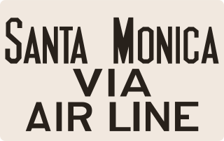
<span class="mw-page-title-main">Upland–San Bernardino Line</span> Pacific Electric streetcar route (1914–1950)

The Upland–San Bernardino Line was an interurban line operated by the Pacific Electric Railway between Downtown Los Angeles and San Bernardino, California. This line also had shorter service that terminated before the end of the line at Baldwin Park, Covina, and San Dimas. Though service along this line in its entirety was discontinued in November 1941, it stands as the fourth-longest rapid transit line in American history, after the Sacramento Northern Chico and Colusa services, and the Pacific Electric's own Riverside–Rialto Line.

<span class="mw-page-title-main">Westgate Line</span> Pacific Electric streetcar line (1906–1940)

The Westgate Line was a suburban route operated by the Pacific Electric Railway from 1911 to 1940. This line was one of four lines connecting Downtown Los Angeles and Santa Monica that did not run through Hollywood. The line is notable for taking a circuitous route towards its end, along San Vicente Boulevard, mainly because it was built to encourage construction of new homes near Pacific Palisades.

<span class="mw-page-title-main">Balboa Line</span> Pacific Electric streetcar line (1904-1950)

The Balboa Line was the southernmost route of the Pacific Electric Railway. It ran between Downtown Los Angeles and the Balboa Peninsula in Orange County by way of North Long Beach, though the route was later cut back to the Newport Dock. It was designated as route 17.

<span class="mw-page-title-main">South Hollywood–Sherman Line</span> Pacific Electric street car line (1896–1953)

The South Hollywood–Sherman Line was a suburban route of the Pacific Electric Railway. The line ran between Downtown Los Angeles and the suburb of Sherman. The line was named after Moses Sherman, who built the line and the Sherman street car yard on the line in West LA. The large 5.56-acre (2.25 ha) rail facility was on Santa Monica Boulevard just west of La Cienega Boulevard. The yard had a steam power house, a car barn and a shop building.

<span class="mw-page-title-main">Whittier Line</span> Pacific Electric interurban route in California

The Whittier Line was a Pacific Electric interurban line which traveled between Los Angeles and Whittier via Huntington Park, Rivera, and Los Nietos. Due to its indirect route, the line was eventually replaced by bus service on Whittier Boulevard.

<span class="mw-page-title-main">La Habra–Fullerton–Yorba Linda Line</span> Pacific Electric interurban route in California

La Habra–Fullerton–Yorba Linda Line was a Pacific Electric interurban line which traveled between Los Angeles and Yorba Linda.

<span class="mw-page-title-main">Redondo Beach via Gardena Line</span> Pacific Electric streetcar line (1911–1940)

Redondo via Gardena was a line of the Pacific Electric Railway. One of two routes to Redondo Beach, this one was faster than the Redondo Beach via Playa del Rey Line as a result of its routing along the quadruple-tracked Watts main line.

<span class="mw-page-title-main">San Pedro via Gardena Line</span> Pacific Electric streetcar route (1903–1940)

San Pedro via Gardena was an interurban line of the Pacific Electric Railway. This was the railway's original route to San Pedro. The line was essential in the establishment of light industry in Torrance. The route closely paralleled the present-day Harbor Transitway.

<span class="mw-page-title-main">Hollywood Line</span> Pacific Electric streetcar line (1909–1953)

The Hollywood Line was a local streetcar line of the Pacific Electric Railway. It primarily operated between Downtown Los Angeles and Hollywood, with some trips as far away as Beverly Hills and West Los Angeles. It was the company's busiest route prior to the opening of the Hollywood Subway. Designated as route 32, the line operated from 1909 until 1954.

<span class="mw-page-title-main">Long Beach Line</span> Pacific Electric interurban route in California

The Long Beach Line was a major interurban railway operated by the Pacific Electric Railway between Los Angeles and Long Beach, California via Florence, Watts, and Compton. Service began in 1902 and lasted until 1961, the last line of the system to be replaced by buses.

<span class="mw-page-title-main">Venice Short Line</span> Los Angeles streetcar route (1897-1950)

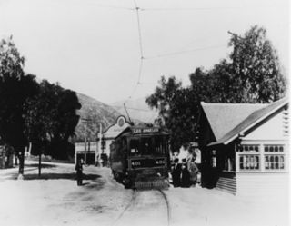
The Venice Short Line was a Pacific Electric (PE) interurban railway line in Los Angeles which traveled from downtown Los Angeles to Venice, Ocean Park, and Santa Monica via Venice Boulevard. The route was especially busy on Sundays, as Venice was PE's most popular beachfront destination.

<span class="mw-page-title-main">Watts Line</span>

The Watts Line was a local line of the Pacific Electric Railway that operated between the Pacific Electric Building in Downtown Los Angeles and the Watts Station at 103rd Street in Watts. It was the primary local service for the Southern District, which also included the Long Beach, San Pedro, Santa Ana and Whittier interurban lines. The route operated along the Southern Division's Four Tracks route, with the Watts Line using the outer tracks and the Long Beach line and other limited stop lines using the inner tracks.

<span class="mw-page-title-main">Riverside–Arlington Line</span> Pacific Electric streetcar route (1893–1943)

The Riverside–Arlington Line is a former Pacific Electric interurban railway line in the Inland Empire. The route provided suburban service between San Bernardino and Arlington with a later extension to Corona. It operated between 1893 and 1943.

<span class="mw-page-title-main">Venice–Inglewood Line</span> Historic rail route in California

The Venice–Inglewood Line is a former Pacific Electric interurban railway line in Los Angeles County, California. Service was very sparse, providing a suburban route between Venice and Inglewood.

References

Definition of Free Cultural Works logo notext.svg  This article incorporates text from a free content work. Licensed under the public domain as a work of the State of California .( license statement/permission ). Text taken from 1981 Inventory of Pacific Electric Routes , California Department of Transportation , . Los Angeles County Metropolitan Transportation Authority .

  1. Crump, Spencer (1977). Ride the big red cars: How trolleys helped build southern California. Trans-Anglo Books. p. 101. ISBN   0-87046-047-1. OCLC   3414090.
  2. 1 2 Yanity, Brian (May 16, 2019). "Fullerton, Rail Town: The Pacific Electric Railway". Fullerton Observer. Retrieved June 1, 2020.
  3. 1 2 3 Veysey, Laurence R. (June 1958). A History Of The Rail Passenger Service Operated By The Pacific Electric Railway Company Since 1911 And By Its Successors Since 1953 (PDF). LACMTA (Report). Los Angeles, California: Interurbans. pp. 28–29. ASIN   B0007F8D84. OCLC   6565577.
  4. 1 2 3 "Pacific Electric Depot, 1918 - Il Ghiotto Restaurant". City of Fullerton. Archived from the original on October 31, 2020. Retrieved June 1, 2020.
  5. "Curtailment Of P. E. Service To Brea Requested". Santa Ana Register. May 24, 1935. p. 2 via Newspapers.com. Open Access logo PLoS transparent.svg
  6. "La Habra-Yorba Linda-Fullerton Line". Electric Railway Historical Association of Southern California. Retrieved June 1, 2020.
  7. "Pacific Electric Railway: "Comfort, Speed, Safety"". American-rails.com. Retrieved June 1, 2020.
  8. "Fullerton May Lose Rail Line". Los Angeles Times. October 29, 1939. p. 52 via Newspapers.com. Open Access logo PLoS transparent.svg
  9. 1 2 3 4 5 "Fullerton Heritage Present: The Pacific Electric Railway Depot". Fullerton Observer. October 9, 2023. Retrieved November 10, 2023.
  10. "Still intersecting FJC was "Boxcar Avenue," the Pacific Electric Railway's right-of-way through the campus". Fullerton College Library. 2012. Retrieved June 1, 2020.
  11. Coyote Hills (Map). 1935. Retrieved November 10, 2023.
  12. Anaheim (Map). 1949. Retrieved November 10, 2023.
Template:Attached KML/Fullerton Line
KML is not from Wikidata