
Bassetlaw is a local government district in north Nottinghamshire, England. Its council is based in the town of Worksop; the other towns in the district are Retford, Tuxford and Harworth Bircotes. The district also contains numerous villages and surrounding rural areas.

North Leverton with Habblesthorpe is a village and civil parish in the English county of Nottinghamshire. It is about 5 miles or 8 km east of Retford. The population as at the 2011 Census was 1,047, and in the Census 2021 it had increased to 1,079.
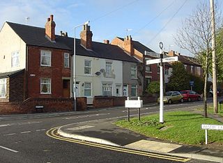
Awsworth is a village and civil parish in the Borough of Broxtowe, Nottinghamshire, England. Its population of 2,266 in the 2001 census and 2,204 in that of 2011, further decreasing to 2,166 for the 2021 census. It is a component of the Greater Nottingham area, between Kimberley, Nottinghamshire and Ilkeston, Derbyshire. It has been a civil parish since 1894.
Bilsthorpe is a village and civil parish in the Newark and Sherwood district of Nottinghamshire, England. According to the 2001 census it had a population of 3,076, increasing to 3,375 at the 2011 census, and dropping slightly to 3,365 at the 2021 census. It is located near the junction of the A614 and A617, around 5 miles south of Ollerton, 9 miles east of Mansfield and 6 miles north-west of Southwell.

Greater Eston is part of the Borough of Redcar and Cleveland, North Yorkshire, England. The name is used by the borough council to describe the centres of Eston, Grangetown, Normanby, Ormesby, South Bank and Teesville.

Hawton is an English hamlet and civil parish in Nottinghamshire, about two miles (3.2 km) south of town of Newark-on-Trent, near the River Devon, a tributary of the River Trent. Its population was recorded as 147 in the 2011 census. Hawton alone reported 80 residents at the 2021 census.

Hoveringham is a small village and civil parish in Nottinghamshire, about 10 miles (16 km) northeast of the county town of Nottingham and on the west side of the River Trent, and just off the A612 trunk road to Southwell. The population of the civil parish as taken at the 2011 census was 359, decreasing to 308 at the 2021 census. The adjacent area has extensive sand and gravel deposits which have been quarried there for many years.

Caunton is a village and civil parish in the Newark and Sherwood district of Nottinghamshire on the A616, six miles (9.7 km) north-west of Newark-on-Trent, in the NG23 postcode. The population of the civil parish at the 2011 census was 483, and this increased to 508 at the 2021 census.
Kirklington is a village and civil parish in the Newark and Sherwood district of Nottinghamshire, England. The population as of the 2011 census was 400, falling to 388 at the 2021 census. Kirklington lies on the A617 road between Newark and Mansfield.

Haughton is a hamlet in the English county of Nottinghamshire.

Kneesall is a village and civil parish in the East Midlands of England in the county of Nottinghamshire. The population of the civil parish at the 2011 census was 221, increasing slightly to 227 at the 2021 census. Forming part of the Newark and Sherwood district, Kneesall is situated on the A616 road between Newark-on-Trent and Ollerton. The village is three miles from neighbouring Eakring and four miles from Laxton.

Preston Rural North is an electoral ward in the City of Preston, Lancashire, England. The ward is the largest by area in the city, containing the smaller and smallest villages from the northern areas of Preston, from Woodplumpton bordering the M55 motorway junction at Broughton, to Beacon Fell at the border of the borough of Wyre.

The Milton Keynes urban area or Milton Keynes Built-up Area is a designation established by the United Kingdom's Office for National Statistics. Milton Keynes has no statutory boundary: the 1967 designated area only determined the area assigned to the Milton Keynes Development Corporation for development. The wider urban area outside that designation includes Newport Pagnell and Woburn Sands as well as Aspley Guise (Bedfordshire) and part of Stoke Hammond civil parish.
Stainborough is a civil parish in the Metropolitan Borough of Barnsley in South Yorkshire, England. At the 2001 census it had a population of 399, reducing slightly to 390 at the 2011 Census.

Fernwood is a village and civil parish in the Newark and Sherwood district of Nottinghamshire, England. The parish, which then included Balderton, had a population of 10,298 in 2001. It is a suburb of Newark-on-Trent. The population of the civil parish was given as 2,190 in the 2011 census, Balderton by that time was a separate civil parish. Fernwood itself increased to 3,054 at the 2021 census.
Heck is a civil parish in the English county of North Yorkshire. The population of this civil parish at the census 2011 was 201, a slight drop on the 2001 census figure of 209.

Preston, commonly known as the City of Preston, is a local government district with city status in Lancashire, England. It lies on the north bank of the River Ribble and has a population of 147,617 (2021). The neighbouring districts are Ribble Valley, South Ribble, Fylde and Wyre.

Gunthwaite is a hamlet in the Metropolitan Borough of Barnsley in South Yorkshire, England. It is in the civil parish of Gunthwaite and Ingbirchworth and is on the boundary of Kirklees in West Yorkshire. At the 2001 Census, the parish had a population of 400, increasing to 460 at the 2011 Census, and now estimated to be around 600.
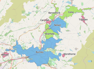
The Burnley built-up area is an urban area or conurbation which extends from the town of Burnley to Padiham, Brierfield, Nelson, Barrowford and Colne in Lancashire, England. The area takes in parts of the boroughs of Burnley and Pendle, and also small parts of Hyndburn and Ribble Valley. It also includes a number of villages such as Blacko, Trawden and Worsthorne. In 2011 the area was recorded at having a population of 149,422. It is the third most populous urban area in Lancashire after Preston and Blackpool, with slightly more people than the urban areas of Cambridge or York.

The Wrexham Built-up area is an area of land defined by the United Kingdom Office for National Statistics (ONS) for population monitoring purposes. It is an urban conurbation fully within Wrexham County Borough and consists of the urban area centred on the city of Wrexham. Until the 2021 census, it also included the historically industrial settlements to the west including Gwersyllt, Rhostyllen, Brymbo, Bradley and New Broughton.


