
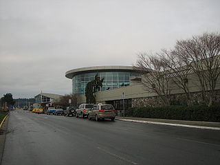
Vancouver International Airport is an international airport located on Sea Island in Richmond, British Columbia, serving the city of Vancouver and the Lower Mainland region. It is located 12 km (7.5 mi) from Downtown Vancouver. YVR is the second busiest airport in Canada by passenger traffic, behind Toronto Pearson International Airport in Ontario. As a trans-Pacific hub, the airport has more direct flights to China than any other airport in North America or Europe. It is a hub for Air Canada and WestJet. Vancouver International Airport is one of eight Canadian airports that have US Border Pre-clearance facilities. It is also one of the few major international airports to have a terminal for scheduled float planes.

Skimboarding or skimming is a boardsport in which a skimboard is used to glide across the water's surface to meet an incoming breaking wave, and ride it back to shore. There are currently 3 U.S. based competitive organizations including Premier Skim, Skim USA, and the United Skim Tour. Wave-riding skimboarders perform a variety of surface and air maneuvers, at various stages of their ride, out to, and back with, the wave. Some of these are known as "wraps", "big spins", "360 shove-its" and "180s". Unlike surfing, skimboarding begins on the beach by dropping the board onto the thin wash of previous waves. Skimboarders use their momentum to skim out to breaking waves, which they then catch back into shore in a manner similar to surfing.
Victoria International Airport serves Victoria, British Columbia, Canada. It is 12 nautical miles north northwest of Victoria on the Saanich Peninsula, with the bulk of the airport in North Saanich, and a small portion of the airfield extending into Sidney. The airport is run by the Victoria Airport Authority. YYJ has many nonstop daily flights to Vancouver International Airport, which is a major airport serving many global routes. Additionally, Victoria International has nonstop service to Seattle (SEA), Toronto (YYZ), Montreal, Calgary (YYC), Edmonton (YEG), and several smaller cities in British Columbia and Yukon. The airport also has seasonal nonstop service to several Mexican resort destinations. Non-stop service between Victoria and the United States decreased by 50% at the beginning of September 2019 when Delta Airlines permanently ended its three daily flights to Seattle, after which only Alaska Airlines continued to fly the route.

HVDC Vancouver Island is a de-energized high-voltage direct current interconnection between Arnott Substation (ARN) in Delta, British Columbia at 49°5′31″N123°2′31″W on the Canadian mainland, and the Vancouver Island Terminal (VIT) in Duncan, British Columbia on Vancouver Island at 48°49′39″N123°42′55″W. It went into operation in 1968 and was extended in 1977. HVDC Vancouver Island consists of three overhead line sections with a total length of 42 kilometres and two submarine cable sections with a length of 33 kilometres. Pole 1 ceased operation in 2014, and Pole 2 ceased operation in 2016. The infrastructure remains in place and portions may be re-used in the future.

Galiano Island is one of the Southern Gulf Islands located between Vancouver Island and the Lower Mainland of British Columbia, Canada. Located on the west side of the Strait of Georgia, the island is bordered by Mayne Island to the southeast, Salt Spring Island to the west and Valdes Island to the northwest. Galiano is part of the Capital Regional District Electoral Area G, and has a permanent population of 1,396 inhabitants as of 2021.
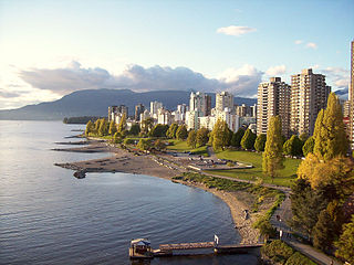
English Bay is an open bay northwest of the Burrard Peninsula in British Columbia, Canada, extending from the headland between Siwash Rock and Prospect Point on Vancouver's Downtown peninsula in the northeast, to the northwestern tip of Point Grey in the southwest. The bay encompasses the coasts of Stanley Park, the West End, Kitsilano, West Point Grey and the University Endowment Lands, and makes up the southeastern portion of the outer Burrard Inlet. There is a narrow inlet named False Creek at its eastern end.
Collinson Point Provincial Park is a provincial park on Galiano Island, British Columbia, Canada. It is located between Mount Galiano and the western approaches to Active Pass. The area is 23.68 hectares, with approximately 500 metres of waterfront.
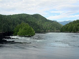
Dionisio Point Provincial Park is a provincial park campground in the southern Gulf Islands of British Columbia, Canada. It is located at the northwestern tip of Galiano Island, across Porlier Pass from Valdes Island.

Sea Island is an island in the Fraser River estuary in the city of Richmond, British Columbia, Canada. It is located south of the city of Vancouver and northwest of Lulu Island.
Saturna Island is a mountainous island, about 31 square kilometres (12 sq mi) in size, in the Southern Gulf Islands chain of British Columbia, Canada. It is situated to be approximately midway between the Lower Mainland of B.C. and Vancouver Island, and is the most easterly of the Gulf Islands. It is surrounded on three sides by the Canada–United States border. To the north is Point Roberts, Washington, and to the east and south are the San Juan Islands. There is a First Nations reserve on the island for the Tsayout and Tseycum Nations. The island has a permanent population of around 350, however, this number increases during the summer season.

Sea Island Centre is an at-grade station on the Canada Line of Metro Vancouver's SkyTrain rapid transit system. The station is located on Sea Island in Richmond, British Columbia.

Dionisio Alcalá Galiano was a Spanish naval officer, cartographer, and explorer. He mapped various coastlines in Europe and the Americas with unprecedented accuracy using new technology such as chronometers. He commanded an expedition that explored and mapped the Strait of Juan de Fuca and the Strait of Georgia, and made the first European circumnavigation of Vancouver Island. He reached the rank of brigadier and died during the Battle of Trafalgar.

Jericho Beach, known originally as iy'a'l'mexw in Squamish, a Vancouver beach, is located west of the seaside neighbourhood of Kitsilano. It is surrounded by Jericho Beach Park, a grassy area with a pond, which is a picnic destination. Jericho Beach is the home of the Jericho Sailing Centre Association.

Valdes Island is one of the Gulf Islands located in the Strait of Georgia, British Columbia, Canada. It is across Porlier Pass from Galiano Island, which lies to the southeast. It has an area of 23 square kilometres, and is 1.6 kilometres wide by 16 kilometres in length. The island is popular with kayakers, boaters and has historically been the site of several human settlements.

Zuma Beach is a county beach at 30000 Pacific Coast Highway (PCH) in Malibu, California. One of the largest and most popular beaches in Los Angeles County, California, it is known for its long, wide sands and excellent surf. It consistently ranks among the healthiest beaches for clean water conditions in Los Angeles County.
Cordero Channel is a strait in British Columbia, Canada, located between the mainland and Vancouver Island, among the Discovery Islands north of the Strait of Georgia. Cordero Channel runs north of Sonora Island, East Thurlow Island, and part of West Thurlow Island. Its eastern end connects to the mouth of Bute Inlet and to Calm Channel, at Stuart Island. Its west end is marked by the mouth of Loughborough Inlet, beyond which the channel is called Chancellor Channel, which continues west to Johnstone Strait.

Tofino is a town of approximately 2,516 residents on the west coast of Vancouver Island in the Canadian province of British Columbia. The District of Tofino is located at the western terminus of Highway 4 on the tip of the Esowista Peninsula at the southern edge of Clayoquot Sound. It is situated in the traditional territory of the Tla-o-qui-aht First Nations and is called Načiks in the Nuu-chah-nulth language.
O'Donohue Park is a public green space located in the Far Rockaway neighborhood on the Rockaway Peninsula of Queens in New York City. The park is located at the eastern tip of the Rockaway Beach and Boardwalk.


