Spenazuma, Arizona

Last updated

Spenazuma, Arizona
USA Arizona location map.svg
Red pog.svg
Spenazuma
Location in the state of Arizona
Usa edcp location map.svg
Red pog.svg
Spenazuma
Spenazuma (the United States)
Coordinates: 32°57′17″N110°11′44″W / 32.95472°N 110.19556°W / 32.95472; -110.19556
Country United States
State Arizona
County Graham
Founded:1898
Abandoned:1899
Time zone UTC-7 (MST (no DST))

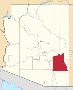
Spenazuma was a short-lived mining town, now a ghost town, in Graham County, Arizona, United States. The townsite is now privately owned, and the site of a working ranch.

Contents

History

The town of Spenazuma was part of an elaborate swindle by an east coast con man, Richard C. Flower, to sell shares in the Spenazuma Mining Company. In 1898, Flower bought some nearby mining claims, laid out the townsite of Spenazuma, and sold shares in eastern states on the pretense that the Spenazuma Mining Company owned gold mines of immense value. Several trainloads of eastern investors were brought to Spenazuma to sustain the illusion.

It is unclear how large the mining town was during its brief life, although friendly newspaper accounts credit it with several stores and businesses, and regular stagecoach service to the railroad station at Geronimo, Arizona.

The swindle collapsed after an investigation by Arizona Republican reporter George Smalley in 1899. The town was quickly deserted. Flower ostensibly dropped out of the company management, although the remaining management immediately started another mining swindle at Aura, Arizona, now also a ghost town. [1] [2]

Geography

The townsite is at 32°57′17″N110°11′44″W / 32.95472°N 110.19556°W / 32.95472; -110.19556 , at an elevation of 3840 feet above sea level.

Related Research Articles

<span class="mw-page-title-main">Congress, Arizona</span> CDP in Yavapai County, Arizona

Congress is a census-designated place (CDP) in Yavapai County, Arizona, United States. Once a gold-mining center for the Congress Mine and then a ghost town, Congress now serves as a retirement and bedroom community for nearby Wickenburg. The population was 1,811 at the 2020 census.

<span class="mw-page-title-main">Swansea, Arizona</span> Ghost town in La Paz County, Arizona

Swansea is a ghost town in La Paz County in the U.S. state of Arizona. It was settled circa 1909 in what was then the Arizona Territory. It served as a mining town as well as a location for processing and smelting the copper ore taken from the nearby mines.

<span class="mw-page-title-main">Fairbank, Arizona</span> Ghost town in Cochise County, Arizona

Fairbank is a ghost town in Cochise County, Arizona, next to the San Pedro River. First settled in 1881, Fairbank was the closest rail stop to nearby Tombstone, which made it an important location in the development of southeastern Arizona. The town was named for Chicago investor Nathaniel Kellogg Fairbank who partially financed the railroad, and was the founder of the Grand Central Mining Company, which had an interest in the silver mines in Tombstone. Today Fairbank is located within the San Pedro Riparian National Conservation Area.

<span class="mw-page-title-main">Gilman, Colorado</span> Town in Colorado, United States

Gilman is an abandoned mining town in southeastern Eagle County, Colorado, United States. The Gilman post office operated from November 3, 1886, until April 22, 1986. The U.S. Post Office at Minturn now serves Gilman postal addresses.

<span class="mw-page-title-main">Clinton Creek</span> Ghost town in Yukon, Canada

Clinton Creek is a ghost town in Yukon. It was a small company-owned asbestos mining town in western Yukon near the confluence of the Yukon and Fortymile rivers. It operated by the Cassiar Asbestos Corporation, which also operated the asbestos mine in Cassiar, British Columbia, from 1967 to 1978, when it was closed and all the buildings were auctioned off.

<span class="mw-page-title-main">Charleston, Arizona</span> Ghost town in Arizona, United States

Charleston is a ghost town in Cochise County in the southeastern part of the U.S. state of Arizona. It was occupied from the late-1870s through the late-1880s, and was located in what was then known as the Arizona Territory. Located on the west bank of the San Pedro River, Charleston's economy was based on milling silver ore mined from nearby Tombstone in the community of Millville, located directly across the river.

<span class="mw-page-title-main">Contention City, Arizona</span> Ghost town in Arizona, United States

Contention City or Contention is a ghost mining town in Cochise County in the southeastern part of the U.S. state of Arizona. It was occupied from the early-1880s through the late-1880s in what was then known as the Arizona Territory. Only a few foundations now remain of this boomtown which was settled and abandoned with the rise and fall of silver mining in and around the area of Tombstone.

<span class="mw-page-title-main">Tiger, Arizona</span> Former populated place in Pinal County, Arizona

Tiger is a former populated place in Pinal County in the U.S. state of Arizona. The town was settled as Schultzcirca 1881 in what was then the Arizona Territory, then later reestablished as Tiger after World War I.

<span class="mw-page-title-main">Cleator, Arizona</span> Ghost town in Yavapai County, Arizona

Cleator, formerly Turkey Creek or Turkey, is a near ghost town and small community in Yavapai County, Arizona, in the Southwestern United States.

Picacho is an unincorporated community in Imperial County, California. It is located on the Colorado River 29 miles (47 km) south-southeast of Palo Verde, at an elevation of 203 feet.

<span class="mw-page-title-main">Lake Valley, Sierra County, New Mexico</span>

Lake Valley was a silver-mining town in Sierra County, U.S. state of New Mexico.

<span class="mw-page-title-main">Smoky Hill City, Kansas</span> Ghost town in Ellis County, Kansas

Smoky Hill City is a ghost town in Lookout Township, Ellis County, Kansas, United States. It lies approximately 12 miles (19 km) southwest of Hays.

<span class="mw-page-title-main">Sego, Utah</span> Ghost town in Utah, United States

Sego is a ghost town in Grand County, Utah, United States. It lies in the narrow, winding Sego Canyon, in the Book Cliffs some 5 miles (8.0 km) north of Thompson Springs. Formerly an important eastern Utah coal mining town, Sego was inhabited about 1910–1955. The town is accessed via the grade of the Ballard & Thompson Railroad, a spur from the Denver and Rio Grande Western built by the founders of the town to transport the coal.

<span class="mw-page-title-main">Helvetia, Arizona</span> Ghost town in Pima County, Arizona

Helvetia is a ghost town in Pima County, Arizona, United States that was settled in 1891 and abandoned in the early 1920s. Helvetia is an ancient name for Switzerland. Today, only the Ray Mine and cemetery are visitable, as the rest of the town has been fenced off due to active mining operations.

<span class="mw-page-title-main">Harshaw, Arizona</span> Ghost town in Arizona, United States

Harshaw is a ghost town in Santa Cruz County in the southeastern part of the U.S. state of Arizona. The town was settled in the 1870s, in what was then Arizona Territory. Founded as a mining community, Harshaw is named after the cattleman-turned-prospector David Tecumseh Harshaw, who first successfully located silver in the area. At the town's peak near the end of the 19th century, Harshaw's mines were among Arizona's highest producers of ore, with the largest mine, the Hermosa, yielding approximately $365,455 in bullion over a four-month period in 1880.

Christmas is an uninhabited mining community in Gila County, Arizona, United States. The mine which led to creation of the town was staked on Christmas Day 1902, prompting the name. During the three decades in which the town's post office operated it was a popular destination for holiday mail seeking a "Christmas" postmark. The mine is also the location where the minerals apachite, junitoite, and ruizite were first discovered.

<span class="mw-page-title-main">Twin Buttes, Pima County, Arizona</span> Town

Twin Buttes is a populated place on the east flank of the Sierrita Mountains approximately twenty miles south of Tucson, in Pima County, Arizona, United States. Named after a prominent hill located next to the town, Twin Buttes was founded as a small mining town circa 1903 and abandoned around 1930. Much of the actual town site is now buried underneath mine tailings, and all that remains is the Twin Buttes Cemetery.

<span class="mw-page-title-main">Hale Ranch</span> Cattle ranch in Santa Cruz County, Arizona

The Hale Ranch is a working cattle ranch headquartered in the ghost town of Harshaw, in the Patagonia Mountains of southeastern Arizona.

<span class="mw-page-title-main">Highland Park, Yavapai County, Arizona</span> Populated place in Arizona, United States

Highland Park, also known as Highland Pines, is a populated place situated near Prescott and within the Prescott National Forest, in Yavapai County, Arizona, United States. Highland Pines is the promotional name associated with the Highland Park areas several subdivisions. In the Arizona Territorial era up to 1912, and Statehood until around the late 1920s, this particular area of land acted as a cattle ranch with a mining history, lies within the Thumb Butte Mining District, which appears to be initially platted by the Arizona Corporation Highland Pine Properties Inc. beginning in the late 1950s.

Sundad is an unincorporated area in the far west of Maricopa County, Arizona, United States, along the border of Yuma County. It has an estimated elevation of 965 feet (294 m) above sea level. It is located north of Agua Caliente and east of Sacation Flats.

References

  1. Plazak, Dan (February 1, 2006). A Hole in the Ground with a Liar at the Top . Salt Lake: University of Utah Press. pp.  159–165. ISBN   0-87480-840-5.
  2. Donaldson, W. Scott (December 2002). Arizona Mining Scams and Unassayable Ore Projects of the Late 20th Century (PDF). Arizona Department of Mines and Mineral Resources. p. 3.