St. Catherine's Lighthouse

Last updated

St Catherine's Lighthouse
CLight-wyrdlight-6712.jpg
The lighthouse, with fog-signal tower attached
Isle of Wight UK relief location map.jpg
Lighthouse icon centered.svg
Isle of Wight
Location St. Catherine's Point
Isle of Wight
England
Coordinates 50°34′32.4″N1°17′51.9″W / 50.575667°N 1.297750°W / 50.575667; -1.297750 Coordinates: 50°34′32.4″N1°17′51.9″W / 50.575667°N 1.297750°W / 50.575667; -1.297750
Year first constructedc.1323 (first)
Year first lit1838 (current)
Automated1997
Construction ashlar
Tower shapehexagonal tower
Markings / patternwhite tower and lantern
Tower height27 m (89 ft)
Focal height41 m (135 ft)
Current lens2nd order four panel catadioptric
Intensity821,000 candela
Range25 nmi (46 km; 29 mi)
Characteristic Fl W 5s.
Admiralty numberA0774
NGA number1064
ARLHS numberENG-143
Managing agentTrinity House [1]
HeritageGrade II listed building  Blue pencil.svg

St. Catherine's Lighthouse is a lighthouse located at St Catherine's Point at the southern tip of the Isle of Wight. It is one of the oldest lighthouse locations in Great Britain.

Lighthouse structure designed to emit light to aid navigation

A lighthouse is a tower, building, or other type of structure designed to emit light from a system of lamps and lenses and to serve as a navigational aid for maritime pilots at sea or on inland waterways.

St Catherines Point

St. Catherine's Point is the southernmost point on the Isle of Wight. It is close to the village of Niton and the point where the Back of the Wight changes to the Undercliff of Ventnor.

Isle of Wight County and island of England

The Isle of Wight is a county and the largest and second-most populous island in England. It is in the English Channel, between 2 and 5 miles off the coast of Hampshire, separated by the Solent. The island has resorts that have been holiday destinations since Victorian times, and is known for its mild climate, coastal scenery, and verdant landscape of fields, downland and chines.

Contents

Origins

The first lighthouse was established on St. Catherine's Down in 1323 on the orders of the Pope, after a ship ran aground nearby and its cargo was either lost or plundered. Once part of St. Catherine's Oratory, its octagonal stone tower can still be seen today on the hill to the west of Niton. It is known locally as the "Pepperpot". [2] Nearby there are the footings of a replacement lighthouse begun in 1785, but this was never completed because the hill is prone to dense fog. [3] It is sometimes called the "salt pot". [4]

St. Catherines Down chalk down on the Isle of Wight

St. Catherine's Down is a chalk down on the Isle of Wight, located near St Catherine's Point, the southernmost point on the island. The Down rises to 240 metres at its highest point, between the towns of Niton and Chale.

Pope John XXII pope from 1316 to his death in 1334

Pope John XXII, born Jacques Duèze, was Pope from 7 August 1316 to his death in 1334.

St. Catherines Oratory medieval lighthouse on the Isle of Wight, England

St. Catherine's Oratory is a medieval lighthouse on St. Catherine's Down, above the southern coast of the Isle of Wight. It was built by Lord of Chale Walter de Godeton as an act of penance for plundering wine from the wreck of St. Marie of Bayonne in Chale Bay on 20 April 1313. The tower is known locally as the "Pepperpot" because of its likeness.

History

The lighthouse c.1910 St Catherine's Lighthouse c1910 - Project Gutenberg eText 17296.jpg
The lighthouse c.1910

The new lighthouse, built by Trinity House in 1838, was constructed as a 40-metre (130 ft) stone tower. When first built the light was oil-fuelled; its lamp, with four concentric wicks, was set within a large (first-order) fixed dioptric lens, built by Cookson & co. and surmounted by 250 mirrors (which were later replaced with prisms). [5] It was first lit on 1 March 1840; [6] however, the light was often obscured by fog, which led in due course to the height of the tower being reduced by 13-metre (43 ft) in 1875. At the same time the lamp was increased from four wicks to six and a system of 'dioptric mirrors' (prisms) was installed to redirect light from the landward side of the lamp out to sea. [7]

Trinity House private corporation governed under a Royal Charter

The Corporation of Trinity House of Deptford Strond, known as Trinity House, is a private corporation governed under a Royal Charter.

Fresnel lens type of compact lens

A Fresnel lens is a type of compact lens originally developed by French physicist Augustin-Jean Fresnel for lighthouses.

In 1866 a Daboll trumpet fog signal was installed in a building on the cliff edge; it used a caloric engine to sound a reed attached to an acoustic horn.

Daboll trumpet

A Daboll trumpet is an air trumpet foghorn which was developed by an American, Celadon Leeds Daboll, of New London, Connecticut. It was basically a small coal-fired hot air engine, which compressed air in a cylinder on top of which was a reed horn.

Reed pipe

A reed pipe is an organ pipe that is sounded by a vibrating brass strip known as a reed. Air under pressure is directed towards the reed, which vibrates at a specific pitch. This is in contrast to flue pipes, which contain no moving parts and produce sound solely through the vibration of air molecules. Reed pipes are common components of pipe organs.

In the 1880s the decision was taken to convert the St Catherine's light to electric power. In 1888 a carbon arc lamp was installed, linked to a powerful set of De Méritens magneto-electric machines, powered by three Robey non-condensing compound steam engines. (St Catherine's was the last English lighthouse to be provided with an arc lamp). [8] A new optic was also provided (a second-order 16-sided revolving lens) along with a subsidiary apparatus which redirected light from the rear above the main lens to form a red sector light directed towards the Needles. [7] As well as a new Engine House, more cottages were built, to accommodate the additional staff required to operate the generating plant. [9]

Magneto electricity-producing machine

A magneto is an electrical generator that uses permanent magnets to produce periodic pulses of alternating current. Unlike a dynamo, a magneto does not contain a commutator to produce direct current. It is categorized as a form of alternator, although it is usually considered distinct from most other alternators, which use field coils rather than permanent magnets.

Robey & Co

Robey and Co. was an engineering company based in Lincoln, England which can be traced back to at least 1849.

Compound steam engine type of steam engine where steam is expanded in two or more stages

A compound steam engine unit is a type of steam engine where steam is expanded in two or more stages. A typical arrangement for a compound engine is that the steam is first expanded in a high-pressure (HP) cylinder, then having given up heat and losing pressure, it exhausts directly into one or more larger-volume low-pressure (LP) cylinders. Multiple-expansion engines employ additional cylinders, of progressively lower pressure, to extract further energy from the steam.

A new fog signal house was also built in 1888; in it a pair of double-noted 5-inch sirens were installed, sounding through a pair of upright horns, which emerged through the roof and were angled out to sea. Compressed air for the sirens was piped underground from the engine house, where the three engines were linked to an air compressor by way of a common drive shaft; [10] compressed air was also used to power the mechanism that turned the lens. The sirens sounded two blasts every minute: a higher note followed by a low note. [9]

Drive shaft mechanical component for transmitting torque and rotation

A drive shaft, driveshaft, driving shaft, tailshaft, propeller shaft, or Cardan shaft is a mechanical component for transmitting torque and rotation, usually used to connect other components of a drive train that cannot be connected directly because of distance or the need to allow for relative movement between them.

In 1901 a series of trials of different sirens and reeds attached to trumpets of different sizes and designs took place at St Catherine's (which had sufficient engine power to produce the required volume of compressed air). The tests were overseen by Lord Rayleigh, scientific adviser to Trinity House, whose distinctive and eponymous design of fog signal trumpet was installed at several different fog signal stations (though not at St Catherine's itself) in the wake of the trials. [10]

In 1904 the 16-sided optic was removed from St Catherine's (and installed instead in South Foreland Lighthouse); the current 4-sided optic was installed in its place. [11] At the same time the red sector light was reconfigured, to shine from a window lower down in the tower, marking Atherfield Ledge. [12] The arc lamp was decommissioned in the 1920s; by this time it was the last operational arc lamp in a lighthouse in the UK (it is now displayed as an exhibit in Southsea Castle.) [13]

By 1932 the fog horn house was being undermined by erosion; it was demolished and a second (smaller) tower was then built alongside the lighthouse to house a new more powerful 12-inch siren. On 1 June 1943 a bombing raid destroyed the engine house, killing the three duty keepers. [14] As part of the post-war repairs, a diaphone was installed in place of the siren. This was itself replaced by a 'supertyfon' air horn in 1962, when new engines and compressors were also installed; the fog signal was discontinued in 1987. [10]

Present day

View of the lighthouse, looking south west out to the English Channel St Catherine's Lighthouse, Isle of Wight, UK.jpg
View of the lighthouse, looking south west out to the English Channel

Today, the lighthouse has a range of 25 nautical miles (46 km; 29 mi) and is the third-most powerful of all the lights maintained by Trinity House. [12] Trinity House provides tours of the lighthouse year round. Furthermore, cottages around the lighthouse can be rented out as holiday accommodation.

See also

Related Research Articles

Longships Lighthouse lighthouse in Cornwall, England

Longships Lighthouse is an active 19th century lighthouse about 1.25 mi (2.01 km) off the coast of Land's End in Cornwall, England. It is the second lighthouse to be built on Carn Bras, the highest of the Longships islets which rises 39 feet (12 m) above high water level. In 1988 the lighthouse was automated, and the keepers withdrawn. It is now remotely monitored from the Trinity House Operations & Planning Centre in Harwich.

Souter Lighthouse lighthouse

Souter Lighthouse is a lighthouse located in the village of Marsden in South Shields, Tyne & Wear, England. Souter was the first lighthouse in the world to be actually designed and built specifically to use alternating electric current, the most advanced lighthouse technology of its day.

Split Rock Lighthouse lighthouse in Minnesota, United States

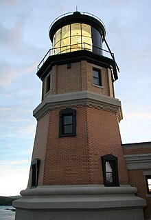
Split Rock Lighthouse is a lighthouse located southwest of Silver Bay, Minnesota, USA on the North Shore of Lake Superior. The structure was designed by lighthouse engineer Ralph Russell Tinkham and was completed in 1910 by the United States Lighthouse Service at a cost of $75,000, including the buildings and the land. It is considered one of the most picturesque lighthouses in the United States.

Pendeen Lighthouse lighthouse in Cornwall, England

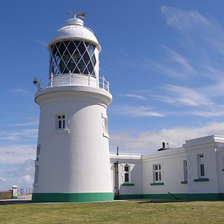
Pendeen Lighthouse, also known as Pendeen Watch is located 2 kilometres (1.2 mi) to the north of Pendeen in west Cornwall, England, United Kingdom. It is located within the Aire Point to Carrick Du SSSI, the Cornwall Area of Outstanding Natural Beauty and the Penwith Heritage Coast. The South West Coast Path passes to the south.

Baily Lighthouse lighthouse in County Dublin, Ireland

The Baily Lighthouse is a lighthouse on the southeastern part of Howth Head in County Dublin, Ireland. It is maintained by the Commissioners of Irish Lights.

Trevose Head Lighthouse lighthouse in St. Merryn, Cornwall, England

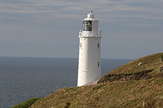
Trevose Head Lighthouse is a lighthouse on Trevose Head on the north Cornish coast at grid reference SW850766 lying to the WSW of Padstow and was sited here as there was previously no light from Land's End to Lundy and it would be visible from Cape Cornwall to Hartland Point.

St Anthonys Lighthouse lighthouse in Gerrans, Cornwall, England

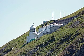
St Anthony's Lighthouse is the lighthouse at St Anthony Head, on the eastern side of the entrance to Falmouth harbour, Cornwall, UK. The harbour is also known as Carrick Roads and is one of the largest natural harbours in the world.

Lizard Lighthouse lighthouse in Landewednack, Cornwall, England

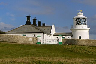
The Lizard Lighthouse is a lighthouse at Lizard Point in Cornwall, England, built to guide vessels passing through the English Channel. It was often the welcoming beacon to persons returning to England, where on a clear night, the reflected light could be seen 100 mi (160 km) away.

South Foreland Lighthouse grade II listed lighthouse at St. Margarets Bay, Dover, Kent, England

South Foreland Lighthouse is a Victorian lighthouse on the South Foreland in St. Margaret's Bay, Dover, Kent, England, used to warn ships approaching the nearby Goodwin Sands. Built in 1843, it went out of service in 1988 and is currently owned by the National Trust. It is notable as having been the first lighthouse to use an electric light, and was the site chosen by Guglielmo Marconi for his pioneering experiments in wireless radio transmissions.

Longstone Lighthouse lighthouse on one of the Farne Islands, England

Longstone Lighthouse is an active 19th century lighthouse located on Longstone Rock in the outer group of the Farne Islands off the Northumberland Coast, England. Completed in 1826, it was originally called the Outer Farne Lighthouse, and complemented the earlier Inner Farne Lighthouse. The lighthouse is best known for the 1838 wreck of the Forfarshire and the role of Grace Darling, the lighthouse keeper's daughter, in rescuing survivors.

Start Point Lighthouse lighthouse in Stokenham, South Hams, Devon, England

Start Point lighthouse was built in 1836 to protect shipping off Start Point in south Devon, England. Open to the public in summer months, it is owned and operated by Trinity House. It has been designated by English Heritage as a grade II listed building.

Bull Point Lighthouse lighthouse in Devon, England

Bull Point Lighthouse is a lighthouse on Bull Point, about one mile (1.6 km) north of the village of Mortehoe, on the northern coast of Devon, England. The lighthouse provides a visual aid to the villages of Mortehoe, Woolacombe and Ilfracombe, and warns of the inhospitable and rocky coast that lines the area.

Hartland Point Lighthouse lighthouse in Hartland, Torridge, Devon, England

Hartland Point Lighthouse is a Grade II listed building at Hartland Point, Devon, England. The point marks the western limit of the Bristol Channel with the Atlantic Ocean continuing to the west. Trinity House, the lighthouse authority for England and Wales, have a lighthouse on the tip of the peninsula.

Needles Lighthouse lighthouse at the Needles, Isle of Wight, England

The Needles Lighthouse is an active 19th century lighthouse on the outermost of the chalk rocks at The Needles on the Isle of Wight in the United Kingdom, near sea level. Designed by James Walker, for Trinity House at a cost of £20,000. It was completed in 1859 from granite blocks, stands 33.25 metres (109.1 ft) high and is a circular tower with straight sides. It replaced an earlier light tower on top of a cliff overhanging Scratchell's Bay, which was first lit on 29 September 1786.

Whitby Lighthouse grade II listed lighthouse in the United kingdom

Whitby Lighthouse is a lighthouse operated by Trinity House. It is on Ling Hill, on the coast to the south-east of Whitby, beyond Saltwick Bay. To distinguish it from the two lighthouses in Whitby itself it is sometimes known as Whitby High lighthouse

Anvil Point Lighthouse lighthouse

The Anvil Point Lighthouse is a lighthouse located near Swanage in Dorset, southern England.

Lowestoft Lighthouse lighthouse in Waveney, Suffolk, England

Lowestoft Lighthouse is a lighthouse operated by Trinity House located to the north of the centre of Lowestoft in the English county of Suffolk. It stands on the North Sea coast close to Ness Point, the most easterly point in the United Kingdom. It acts as a warning light for shipping passing along the east coast and is the most easterly lighthouse in the UK.

Flamborough Head Lighthouse lighthouse in Flamborough, East Riding of Yorkshire, England

Flamborough Head Lighthouse is an active lighthouse located at Flamborough, East Riding of Yorkshire. England. Flamborough Head Lighthouse acts as a waypoint for passing deep sea vessels and coastal traffic, and marks Flamborough Head for vessels heading towards Scarborough and Bridlington.

Lynmouth Foreland Lighthouse lighthouse in Countisbury, North Devon, Devon, England

Lynmouth Foreland Lighthouse is located on Foreland Point. It was completed in 1900 to assist vessels passing through the Bristol Channel, and is a round brick tower painted white. The light is 67 metres (220 ft) above the high tide, and flashes 4 times every 15 seconds; the optic is very similar to that installed in Pendeen Lighthouse the same year.

Orfordness Lighthouse grade II listed lighthouse in the United kingdom

Orfordness Lighthouse is a decommissioned lighthouse on Orford Ness, in Suffolk, England. The 30 metres (98 ft) tower was completed in 1792. The light had a range of 25 nautical miles. It was equipped with an AIS transmitter with MMSI 992351016.

References

  1. St. Catherine's The Lighthouse Directory. University of North Carolina at Chapel Hill. Retrieved 26 April 2016
  2. Woodman and Wilson (2002). The Lighthouses of Trinity House. Bradford on Avon: Reed. ISBN   1-904050-00-X.
  3. "History of the lighthouse at St Catherine's Point". National Trust. Retrieved 1 May 2019.
  4. "A colourful history behind St Catherine's Oratory". National Trust. Retrieved 1 May 2019.
  5. Davenport Adams, W. H. (1891). The Story of our Lighthouses and Lightships: Descriptive and Historical (PDF). London, Edinburgh & New York: Thomas Nelson & Sons. p. 122. Retrieved 27 February 2019.
  6. "Lighthouse management : the report of the Royal Commissioners on Lights, Buoys, and Beacons, 1861, examined and refuted Vol. 2". p. 81.
  7. 1 2 "1892 Institution of Mechanical Engineers: Visits to Works (13: St Catherine's Lighthouse)". Grace's Guide. Retrieved 3 March 2019.
  8. Schiffer, Michael Bryan (2008). Power Struggles: Scientific Authority and the Creation of Practical Electricity before Edison. Cambridge, Massachusetts: MIT Press. p. 278.
  9. 1 2 Woodman, Richard; Wilson, Jane (2002). The Lighthouses of Trinity House. Bradford-on-Avon, Wilts.: Thomas Reed. pp. 96–97.
  10. 1 2 3 Renton, Alan (2001). Lost Sounds: The Story of Coast Fog Signals. Caithness, Scotland: Whittles.
  11. Wikisource:1911 Encyclopædia Britannica/Lighthouse
  12. 1 2 "St Catherine's Lighthouse". Trinity House. Retrieved 3 March 2019.
  13. "Southsea Castle Lighthouse". Waymarking.com. Retrieved 16 March 2019.
  14. "St Catherine's Lighthouse". Red Funnel. Retrieved 26 March 2019.