St. Margaret's Bay, Nova Scotia (administrative district)

Last updated
St. Margarets Bay
Administrative District
Novascotiahrm-smb.png
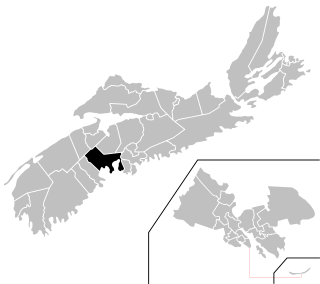
Location of St. Margarets Bay planning area of municipal Halifax.
Canada Nova Scotia location map 2.svg
Red pog.svg
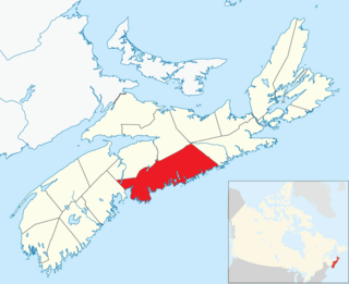
St. Margarets Bay
Location within Nova Scotia
Coordinates: 44°38′40″N63°40′34″W / 44.6444°N 63.6762°W / 44.6444; -63.6762 Coordinates: 44°38′40″N63°40′34″W / 44.6444°N 63.6762°W / 44.6444; -63.6762
CountryFlag of Canada.svg  Canada
ProvinceFlag of Nova Scotia.svg  Nova Scotia
Municipality Halifax Regional Municipality
Founded1612 (Head of St. Margarets Bay)
Communities Black Point, Boutiliers Point, French Village, Glen Haven, Glen Margaret, Hackett's Cove, Head of St. Margaret's Bay, Hubbards, Hubley, Indian Harbour, Ingramport, Lewis Lake, Peggys Cove, Queensland, Seabright, Simms Settlement, Tantallon, Upper Tantallon
Government
  CouncilWestern Region Community Council
Time zone UTC−4 (AST)
  Summer (DST) UTC−3 (ADT)
Area code(s) 902
Part of a series about Places in Nova Scotia

St. Margaret's Bay is the westernmost administrative planning district of the Halifax Regional Municipality in the Canadian province of Nova Scotia.

Nova Scotia Province of Canada

Nova Scotia is one of Canada's three Maritime Provinces, and one of the four provinces that form Atlantic Canada. Its provincial capital is Halifax. Nova Scotia is the second-smallest of Canada's ten provinces, with an area of 55,284 square kilometres (21,300 sq mi), including Cape Breton and another 3,800 coastal islands. As of 2016, the population was 923,598. Nova Scotia is Canada's second-most-densely populated province, after Prince Edward Island, with 17.4 inhabitants per square kilometre (45/sq mi).

It is a rural area located on the southwestern part of Halifax County comprising those communities in the county located on the eastern and northern shores of St. Margaret's Bay through to the county line, terminating at the community of Hubbards. It borders on Hants County to the north and on Lunenburg County to the west. [1]

Halifax County, Nova Scotia County in Nova Scotia, Canada

Halifax County is a county in the Canadian province of Nova Scotia. The Municipality of the County of Halifax was the municipal government of Halifax County, apart from the separately incorporated towns and cities therein. The Municipality was dissolved in 1996, together with those town and city governments, in their amalgamation into Halifax Regional Municipality.

St. Margarets Bay, Nova Scotia bay on the Atlantic coast of Nova Scotia

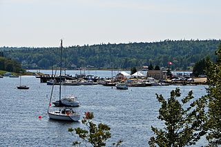
St. Margarets Bay is a bay located on the Atlantic coast of Nova Scotia, Canada on the border of Halifax County and Lunenburg County.

Hubbards, Nova Scotia Rural Community in Nova Scotia, Canada

Hubbards is an unincorporated Canadian rural community on the South Shore of Nova Scotia.

Related Research Articles

Dartmouth, Nova Scotia Urban Community in Nova Scotia, Canada

Dartmouth is a former city and urban community located in the Halifax Regional Municipality of Nova Scotia, Canada. Dartmouth is located on the eastern shore of Halifax Harbour. Dartmouth has been nicknamed the City of Lakes, after the large number of lakes located within its boundaries.

Halifax West Federal electoral district

Halifax West is a federal electoral district in Nova Scotia, Canada, that has been represented in the House of Commons of Canada since 1979. Its population in 2011 was 87,275.

Halifax, Nova Scotia Provincial capital municipality in Nova Scotia, Canada

Halifax, also known as the Halifax Regional Municipality (HRM), is the capital of the Canadian province of Nova Scotia. The municipality had a population of 403,131 in 2016, with 316,701 in the urban area centred on Halifax Harbour. The regional municipality consists of four former municipalities that were amalgamated in 1996: Halifax, Dartmouth, Bedford, and Halifax County.

Peggys Cove, Nova Scotia Community in Nova Scotia, Canada

Peggy's Cove is a small rural community located on the eastern shore of St. Margarets Bay in Nova Scotia's Halifax Regional Municipality, which is the site of Peggys Point Lighthouse.

South Shore—St. Margarets Federal electoral district

South Shore—St. Margarets is a federal electoral district in Nova Scotia, Canada, that has been represented in the House of Commons of Canada since 1968. It covers the South Shore region of Nova Scotia.

Halifax Regional Council

Halifax Regional Council is the governing body of Halifax, formally known as the Halifax Regional Municipality (HRM). Halifax is governed by a mayor-council system, where councillors are elected from sixteen geographic districts though a first past the post system and the Mayor is elected via a municipality wide first past the post vote. Halifax Regional Council was formed in 1996 and consisted of twenty-three councillors and one mayor. It was reduced in size to sixteen councillors and the mayor in 2012. The council meets at Halifax City Hall.

Armdale is a neighbourhood of Halifax, Nova Scotia, Canada.

Chester-St. Margarets

Chester—St. Margaret's is a provincial electoral district in Nova Scotia, Canada, that elects one member of the Nova Scotia House of Assembly. It is located on the South Shore.

Aspotogan Peninsula peninsula

The Aspotogan Peninsula is a peninsula in the eastern part of Lunenburg County, Nova Scotia, separating St. Margarets Bay in the east from Mahone Bay in the west. The peninsula was originally settled by second generation French immigrants on the east side and by second generation German immigrants on the west side. Traditionally fishing was a major industry for communities throughout the peninsula, however other primary industries such as farming and forestry were historically important as well. Shipping and shipbuilding were secondary and tertiary industries that also came into prominence during the 19th and early 20th centuries.

Rockingham is a community located in Nova Scotia's Halifax Regional Municipality.

Chebucto Peninsula

The Chebucto Peninsula is a Canadian peninsula located in central Nova Scotia entirely within the Halifax Regional Municipality on the Atlantic coast.

The Halifax Regional Municipality (HRM) in Nova Scotia, Canada has a widely varied geography.

Timberlea-Prospect

Timberlea—Prospect is a provincial electoral district in Nova Scotia, Canada, that elects one member of the Nova Scotia House of Assembly. Its Member of the Legislative Assembly (MLA) since 2013 has been Iain Rankin of the Nova Scotia Liberal Party.

Timberlea, Nova Scotia

Timberlea is a community located on the rural/suburban fringe of the Halifax Regional Municipality in Nova Scotia, Canada, along the St. Margaret's Bay Rd, which extends from the Armdale Rotary to the Head of St. Margaret's Bay. It begins about 8 miles/13 km from downtown Halifax. The name means a broad meadow in a forest.

Fairview, Nova Scotia human settlement in Canada

Fairview is a former community and current neighbourhood within the urban core of Halifax in Nova Scotia, Canada.

Government in Halifax, Nova Scotia

Halifax, formally known as Halifax Regional Municipality, is located in Nova Scotia, Canada. The municipality is governed by a mayor and a sixteen-person Regional Council, who are elected by geographic district; municipal elections occur every leap year.

Prospect, Nova Scotia Community in Nova Scotia, Canada

Prospect is a Canadian coastal community on the Chebucto Peninsula in Halifax Regional Municipality, Nova Scotia, Canada.

St. Margaret's is a suburb of Annapolis in Anne Arundel County, Maryland, United States on the scenic Broadneck Peninsula. The ZIP code is 21409.

References

  1. "Planning Districts 1 and 3 (St. Margaret's Bay) Area Plan". Halifax. Retrieved 4 July 2017.