St. Thomas, North Dakota

Last updated

St. Thomas, North Dakota
St. Thomas, North Dakota.jpg
St. Thomas, North Dakota
ND Pembina County St Thomas.svg
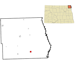
Location of St. Thomas, North Dakota
Coordinates: 48°37′11″N97°26′50″W / 48.61972°N 97.44722°W / 48.61972; -97.44722
CountryUnited States
State North Dakota
County Pembina
Founded1881
Area
[1]
  Total1.01 sq mi (2.63 km2)
  Land1.01 sq mi (2.63 km2)
  Water0.00 sq mi (0.00 km2)
Elevation
[2]
843 ft (257 m)
Population
 (2020) [3]
  Total323
  Estimate 
(2022) [4]
317
  Density318.23/sq mi (122.85/km2)
Time zone UTC-6 (Central (CST))
  Summer (DST) UTC-5 (CDT)
ZIP codes
58276
Area code 701
FIPS code 38-70260
GNIS feature ID1036252 [2]

St. Thomas is a city in Pembina County, North Dakota, United States. The population was 323 at the 2020 census. [3] The city, located in the Red River Valley region.

Contents

History

St. Thomas was laid out in 1881. [5] The city was named after St. Thomas, Ontario. [6]

A U.S. post office has been in operation at St. Thomas since 1881 and is open weekdays. [7]

The St. Thomas Public School was established in 1882. St. Thomas Elementary School and St. Thomas High School offered classes for pre-kindergarten through 12th grade through the 2020-21 school year. The three-person class of 2021 was the last class to graduate from St. Thomas Public School. Pre-K-12th grade students from St. Thomas now attend school in Grafton, ND (in the newly consolidated Grafton School District #18). [8]

Geography

According to the United States Census Bureau, the city has a total area of 1.06 square miles (2.75 km2), all land. [9]

Demographics

Historical population
CensusPop.Note
1890 477
1900 66138.6%
1910 513−22.4%
1920 500−2.5%
1930 59519.0%
1940 503−15.5%
1950 56612.5%
1960 66016.6%
1970 508−23.0%
1980 5283.9%
1990 444−15.9%
2000 4470.7%
2010 331−26.0%
2020 323−2.4%
2022 (est.)317 [4] −1.9%
U.S. Decennial Census [10]
2020 Census [3]

2020 census

As of the census of 2020, there were 323 people lived in St. Thomas. Three-quarters of those residents were born in or near the town itself. It is a racially and ethnically diverse town, where 16% of residents are Latino, 8% are Indigenous, and most other residents are white. According to the census, every man who lives in the town owns his home, and 75% of women do too.

2010 census

As of the census of 2010, there were 331 people, 150 households, and 107 families residing in the city. The population density was 312.3 inhabitants per square mile (120.6/km2). There were 182 housing units at an average density of 171.7 per square mile (66.3/km2). The racial makeup of the city was 94.6% White, 0.6% Native American, 4.5% from other races, and 0.3% from two or more races. Hispanic or Latino of any race were 19.6% of the population.

There were 150 households, of which 27.3% had children under the age of 18 living with them, 53.3% were married couples living together, 9.3% had a female householder with no husband present, 8.7% had a male householder with no wife present, and 28.7% were non-families. 27.3% of all households were made up of individuals, and 11.3% had someone living alone who was 65 years of age or older. The average household size was 2.21 and the average family size was 2.63.

The median age in the city was 46.1 years. 19.6% of residents were under the age of 18; 5.7% were between the ages of 18 and 24; 21.7% were from 25 to 44; 35.2% were from 45 to 64; and 17.8% were 65 years of age or older. The gender makeup of the city was 52.6% male and 47.4% female.

Notable people

Related Research Articles

<span class="mw-page-title-main">Walsh County, North Dakota</span> County in North Dakota, United States

Walsh County is a county in the U.S. state of North Dakota. As of the 2020 census, the population was 10,563. Its county seat is Grafton.

<span class="mw-page-title-main">Towner County, North Dakota</span> County in North Dakota, United States

Towner County is a county in the U.S. state of North Dakota. As of the 2020 census, the population is 2,162. Its county seat is Cando. It is south of the Canada–US border with Manitoba.

<span class="mw-page-title-main">Pembina County, North Dakota</span> County in North Dakota, United States

Pembina County is a county in the U.S. state of North Dakota. At the 2020 census its population was 6,844. The county seat is Cavalier.

<span class="mw-page-title-main">Cavalier County, North Dakota</span> County in North Dakota, United States

Cavalier County is a county in the U.S. state of North Dakota. It is south of the Canada–US border with Manitoba. As of the 2020 census, the population was 3,704. Its county seat is Langdon. The city of Cavalier is in nearby Pembina County.

<span class="mw-page-title-main">St. Vincent, Minnesota</span> City in Minnesota, United States

St. Vincent is a hamlet in Kittson County, Minnesota, United States. The population was 57 at the 2020 census.

<span class="mw-page-title-main">Reeder, North Dakota</span> City in North Dakota, United States

Reeder is a city in Adams County, North Dakota, United States. The population was 125 at the 2020 census.

<span class="mw-page-title-main">Underwood, North Dakota</span> City in North Dakota, United States

Underwood is a city in McLean County, North Dakota, United States. The population was 784 at the 2020 census.

<span class="mw-page-title-main">Bathgate, North Dakota</span> City in North Dakota, United States

Bathgate is a city in Pembina County, North Dakota, United States. It sits on the banks of the Tongue River. The population was 47 at the 2020 census. Bathgate was founded in 1881. In 1908, the North Dakota School for the Blind was placed in Bathgate. The building still stands and is now occupied by a publishing company. Bathgate was the childhood home of former world-champion speed skater and figure skater Norval Baptie.

<span class="mw-page-title-main">Cavalier, North Dakota</span> City in North Dakota, United States

Cavalier is the largest city in Pembina County, North Dakota, United States. It is the county seat of Pembina County. The population was 1,246 at the 2020 census. Cavalier was founded in 1875 and became the county seat in 1911.

<span class="mw-page-title-main">Crystal, North Dakota</span> City in North Dakota, United States

Crystal is a city in Pembina County, North Dakota, United States. The population was 116 at the 2020 census. Crystal was founded in 1879.

<span class="mw-page-title-main">Drayton, North Dakota</span> City in North Dakota, United States

Drayton is a city in Pembina County, North Dakota, United States. The population was 757 at the 2020 census. Drayton was founded in 1878.

<span class="mw-page-title-main">Hamilton, North Dakota</span> City in North Dakota, United States

Hamilton is a city in Pembina County, North Dakota, United States. The population was 46 at the 2020 census.

<span class="mw-page-title-main">Mountain, North Dakota</span> City in North Dakota, United States

Mountain is a city in Thingvalla Township, Pembina County, North Dakota, United States. The population was 80 at the 2020 census. Mountain was founded in 1884.

<span class="mw-page-title-main">Neche, North Dakota</span> City in North Dakota, United States

Neche is a city in Pembina County, North Dakota, United States. It sits on the banks of the Pembina River. The population was 344 at the 2020 census.

<span class="mw-page-title-main">Pembina, North Dakota</span> City in North Dakota, United States

Pembina is a city in Pembina County, North Dakota, United States. The population was 512 at the 2020 census. Pembina is located 2 miles (3.2 km) south of the Canada–US border. Interstate 29 passes on the west side of Pembina, leading north to the Canada–US border at Emerson, Manitoba and south to the cities of Grand Forks and Fargo. The Pembina–Emerson Border Crossing is the busiest between Surrey–Blaine, and Windsor–Detroit, and the fifth busiest along the Canada-United States border. It is one of three 24-hour ports of entry in North Dakota, the others being Portal and Dunseith. The Noyes–Emerson East Border Crossing, located 2 miles (3.2 km) to the east on the Minnesota side of the Red River, also processed cross-border traffic until its closure in 2006.

<span class="mw-page-title-main">Walhalla, North Dakota</span> City in North Dakota, United States

Walhalla is a city in Pembina County, North Dakota, United States. It sits on the banks of the Pembina River, five miles from the border with Manitoba (Canada) and approximately 45 mi (72 km) from the border with Minnesota. The population was 893 at the 2020 census.

<span class="mw-page-title-main">Belcourt, North Dakota</span> CDP in North Dakota, United States

Belcourt is a census-designated place (CDP) in Rolette County, North Dakota, United States. It is within the Turtle Mountain Indian Reservation. The population was 1,510 at the 2020 census.

<span class="mw-page-title-main">Dunseith, North Dakota</span> City in North Dakota, United States

Dunseith is a city in Rolette County, North Dakota, United States. The population was 632 at the 2020 census. Dunseith is best known for its proximity to the International Peace Garden. The port of entry at the Peace Garden is one of three 24-hour ports in North Dakota. Dunseith is also the home of the world's largest turtle sculpture, the "W'eel Turtle", made of more than 2,000 wheels painted green.

<span class="mw-page-title-main">Grafton, North Dakota</span> City in North Dakota, United States

Grafton is a city in the State of North Dakota and is the county seat of Walsh County. As of the 2020 Census, the city of Grafton had a population of 4,170, making it the 16th most populous city in North Dakota. Grafton was founded in 1881.

<span class="mw-page-title-main">Tioga, North Dakota</span> City in North Dakota, United States

Tioga is a city in Williams County, North Dakota, United States. The population was 2,202 at the 2020 census.

References

  1. "ArcGIS REST Services Directory". United States Census Bureau. Retrieved September 20, 2022.
  2. 1 2 U.S. Geological Survey Geographic Names Information System: St. Thomas, North Dakota
  3. 1 2 3 "Explore Census Data". United States Census Bureau . Retrieved November 12, 2023.
  4. 1 2 "City and Town Population Totals: 2020-2022". United States Census Bureau. November 12, 2023. Retrieved November 12, 2023.
  5. "Cities". County of Pembina, North Dakota. Archived from the original on February 18, 2015. Retrieved October 26, 2015.{{cite web}}: CS1 maint: unfit URL (link)
  6. Federal Writer's Project of the Works Progress Administration for the State of North Dakota (1977). The WPA Guide To 1930s North Dakota (2nd ed.). State Historical Society of North Dakota. p. 188. ISBN   1891419145.
  7. "Pembina County". Jim Forte Postal History. Retrieved October 25, 2015.
  8. Thingelstad, Pete (2021). STHS, Final Curtain Call, Senior Graduates 1899-2021. St. Thomas, ND: self published. p. 4.
  9. "US Gazetteer files 2010". United States Census Bureau. Archived from the original on January 12, 2012. Retrieved June 14, 2012.
  10. United States Census Bureau. "Census of Population and Housing" . Retrieved August 30, 2013.