Bathgate, North Dakota

Last updated

Bathgate, North Dakota
ND School for the Blind.jpg
North Dakota School for the Blind in 1908
ND Pembina County Bathgate.svg
Coordinates: 48°52′49″N97°28′26″W / 48.88028°N 97.47389°W / 48.88028; -97.47389
CountryUnited States
State North Dakota
County Pembina
Founded1881
Area
[1]
  Total0.28 sq mi (0.72 km2)
  Land0.28 sq mi (0.72 km2)
  Water0.00 sq mi (0.00 km2)
Elevation
[2]
820 ft (250 m)
Population
 (2020)
  Total47
  Density169.68/sq mi (65.50/km2)
Time zone UTC-6 (CST)
  Summer (DST) UTC-5 (CDT)
ZIP code
58216
Area code 701
FIPS code 38-05260
GNIS feature ID1035924 [2]

Bathgate is a city in Pembina County, North Dakota, United States. It sits on the banks of the Tongue River. The population was 47 at the 2020 census. [3] Bathgate was founded in 1881. In 1908, the North Dakota School for the Blind was placed in Bathgate. [4] The building still stands and is now occupied by a publishing company. Bathgate was the childhood home of former world-champion speed skater and figure skater Norval Baptie. [5]

Contents

History

Bathgate was originally called Bayview, and was laid out under that name in 1879. [6] The present name, after Bathgate, Scotland, was adopted in 1881. [7] A post office called Bathgate has been in operation since that year. [8]

In June 1909, Bathgate experienced an 11-hour thunderstorm that destroyed several buildings and killed a number of horses. [9]

Geography

According to the United States Census Bureau, the town has a total area of 0.27 square miles (0.70 km2), all land. [10]

Demographics

Historical population
CensusPop.Note
1890 377
1900 64170.0%
1910 328−48.8%
1920 3527.3%
1930 292−17.0%
1940 3126.8%
1950 209−33.0%
1960 175−16.3%
1970 133−24.0%
1980 67−49.6%
1990 7511.9%
2000 66−12.0%
2010 43−34.8%
2020 479.3%
2021 (est.)46 [11] −2.1%
U.S. Decennial Census [12]
2020 Census [3]

2010 census

As of the census of 2010, there were 43 people, 22 households, and 11 families residing in the town. The population density was 159.3 inhabitants per square mile (61.5/km2). There were 25 housing units at an average density of 92.6 per square mile (35.8/km2). The racial makeup of the town was 95.3% White and 4.7% Native American. Hispanic or Latino of any race were 2.3% of the population.

There were 22 households, of which 27.3% had children under the age of 18 living with them, 40.9% were married couples living together, 4.5% had a female householder with no husband present, 4.5% had a male householder with no wife present, and 50.0% were non-families. 45.5% of all households were made up of individuals, and 22.7% had someone living alone who was 65 years of age or older. The average household size was 1.95 and the average family size was 2.64.

The median age in the town was 49.5 years. 18.6% of residents were under the age of 18; 2.4% were between the ages of 18 and 24; 23.3% were from 25 to 44; 37.2% were from 45 to 64; and 18.6% were 65 years of age or older. The gender makeup of the city was 51.2% male and 48.8% female.

2000 census

As of the census of 2000, there were 66 people, 25 households, and 18 families residing in the town. The population density was 206.2 inhabitants per square mile (79.6/km2). There were 28 housing units at an average density of 87.5 per square mile (33.8/km2). The racial makeup of the town was 83.33% White, 13.64% Native American, and 3.03% from two or more races.

There were 25 households, out of which 32.0% had children under the age of 18 living with them, 68.0% were married couples living together, 4.0% had a female householder with no husband present, and 28.0% were non-families. 28.0% of all households were made up of individuals, and 8.0% had someone living alone who was 65 years of age or older. The average household size was 2.64 and the average family size was 3.28.

In the city, the population was spread out, with 30.3% under the age of 18, 6.1% from 18 to 24, 33.3% from 25 to 44, 18.2% from 45 to 64, and 12.1% who were 65 years of age or older. The median age was 36 years. For every 100 females, there were 78.4 males. For every 100 females age 18 and over, there were 84.0 males.

The median income for a household in the town was $36,250, and the median income for a family was $51,250. Males had a median income of $37,750 versus $17,083 for females. The per capita income for the city was $13,593. There were 8.7% of families and 4.5% of the population living below the poverty line, including no under eighteens and 33.3% of those over 64.

Related Research Articles

<span class="mw-page-title-main">St. Vincent, Minnesota</span> City in Minnesota, United States

St. Vincent is a hamlet in Kittson County, Minnesota, United States. The population was 57 at the 2020 census.

<span class="mw-page-title-main">Portal, North Dakota</span> City in North Dakota, United States

Portal is a city in Burke County, North Dakota, United States. The population was 125 at the 2020 census. Portal was founded in 1893.

<span class="mw-page-title-main">Canton City, North Dakota</span> City in North Dakota, United States

Canton City, also known as Hensel, is a town located on the east edge of Park Township in Pembina County, North Dakota, United States. The population was 31 at the 2020 census.

<span class="mw-page-title-main">Cavalier, North Dakota</span> City in North Dakota, United States

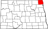
Cavalier is the largest city in Pembina County, North Dakota, United States. It is the county seat of Pembina County. The population was 1,246 at the 2020 census. Cavalier was founded in 1875 and became the county seat in 1911.

<span class="mw-page-title-main">Crystal, North Dakota</span> City in North Dakota, United States

Crystal is a city in Pembina County, North Dakota, United States. The population was 116 at the 2020 census. Crystal was founded in 1879.

<span class="mw-page-title-main">Drayton, North Dakota</span> City in North Dakota, United States

Drayton is a city in Pembina County, North Dakota, United States. The population was 757 at the 2020 census. Drayton was founded in 1878.

<span class="mw-page-title-main">Hamilton, North Dakota</span> City in North Dakota, United States

Hamilton is a city in Pembina County, North Dakota, United States. The population was 46 at the 2020 census.

<span class="mw-page-title-main">Mountain, North Dakota</span> City in North Dakota, United States

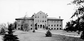
Mountain is a city in Thingvalla Township, Pembina County, North Dakota, United States. The population was 80 at the 2020 census. Mountain was founded in 1884.

<span class="mw-page-title-main">Neche, North Dakota</span> City in North Dakota, United States

Neche is a city in Pembina County, North Dakota, United States. It sits on the banks of the Pembina River. The population was 344 at the 2020 census.

<span class="mw-page-title-main">Walhalla, North Dakota</span> City in North Dakota, United States

Walhalla is a city in Pembina County, North Dakota, United States. It sits on the banks of the Pembina River, five miles (8 km) from the border with Manitoba (Canada) and approximately 45 mi (72 km) from the border with Minnesota. The population was 893 at the 2020 census.

<span class="mw-page-title-main">Dunseith, North Dakota</span> City in North Dakota, United States

Dunseith is a city in Rolette County, North Dakota, United States. The population was 632 at the 2020 census. Dunseith is best known for its proximity to the International Peace Garden. The port of entry at the Peace Garden is one of three 24-hour ports in North Dakota. Dunseith is also the home of the world's largest turtle sculpture, the "W'eel Turtle", made of more than 2,000 wheels painted green.

<span class="mw-page-title-main">Claremont, South Dakota</span> Town in South Dakota, United States

Claremont is a town in Brown County, South Dakota, United States. The population was 108 at the 2020 census.

<span class="mw-page-title-main">Stratford, South Dakota</span> Town in South Dakota, United States

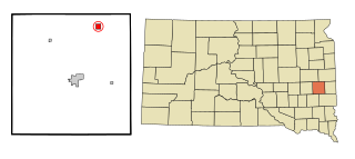
Stratford is a town in southern Brown County, South Dakota, United States. The population was 57 at the 2020 census.

<span class="mw-page-title-main">Westport, South Dakota</span> Town in South Dakota, United States

Westport is a town in western Brown County, South Dakota, United States. The population was 88 at the 2020 census.

<span class="mw-page-title-main">Onaka, South Dakota</span> Town in South Dakota, United States

Onaka is a town in Faulk County, South Dakota, United States. The population was 13 at the 2020 census.

<span class="mw-page-title-main">Orient, South Dakota</span> Town in South Dakota, United States

Orient is a town in Faulk County, South Dakota, United States. The population was 51 at the 2020 census.

<span class="mw-page-title-main">Revillo, South Dakota</span> Town in South Dakota, United States

Revillo is a town in southeastern Grant County, South Dakota, United States. The population was 99 at the 2020 census.

<span class="mw-page-title-main">Lake City, South Dakota</span> Town in South Dakota, United States

Lake City is a town in Marshall County, South Dakota, United States. The population was 45 at the 2020 census. Fort Sisseton Historic State Park, whose fort is listed on the National Register of Historic Places, is located nearby.

<span class="mw-page-title-main">Corona, South Dakota</span> Town in South Dakota, United States

Corona is a town in Roberts County, South Dakota, United States. The population was 69 at the 2020 census.

<span class="mw-page-title-main">Ortley, South Dakota</span> Town in South Dakota, United States

Ortley is a town in Roberts County, South Dakota, United States. The population was 50 according to the 2020 census.

References

  1. "ArcGIS REST Services Directory". United States Census Bureau. Retrieved September 20, 2022.
  2. 1 2 U.S. Geological Survey Geographic Names Information System: Bathgate, North Dakota
  3. 1 2 "Explore Census Data". United States Census Bureau . Retrieved July 16, 2022.
  4. "Start of our School". ndsb.k12.nd.us. Archived from the original on September 21, 2007. Retrieved November 19, 2007.
  5. Helm, Merry (November 26, 2003). "Norval Baptie". Dakota Datebook. Prairie Public Radio. Archived from the original on January 10, 2008. Retrieved November 20, 2007.
  6. Roth Olstad, Geneva (2000). Main Street, North Dakota. Arcadia Publishing. p. 17. ISBN   978-0-7385-0760-6.
  7. "Cities". County of Pembina, North Dakota. Archived from the original on February 18, 2015. Retrieved October 26, 2015.
  8. "Pembina County". Jim Forte Postal History. Retrieved October 25, 2015.
  9. Jackson, William (2021). Dakota Mysteries & Oddities, 2022 Edition. Dickinson, ND: Valley Star Publications. pp. 68–69. ISBN   978-0-9677349-9-6.
  10. "US Gazetteer files 2010". United States Census Bureau. Archived from the original on February 20, 2011. Retrieved June 14, 2012.
  11. "City and Town Population Totals: 2020-2021". United States Census Bureau. July 16, 2022. Retrieved July 16, 2022.
  12. United States Census Bureau. "Census of Population and Housing" . Retrieved August 30, 2013.