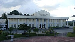
Sual

Last updated
Sual
Municipality of Sual
Sual Pangasinan 2.JPG
Street in Sual
06192jfHighway Churches Pangasinan Bridge Labrador Sual Alaminos Landmarksfvf 08.JPG
Sual Pangasinan.png
Ph locator pangasinan sual.png
Map of Pangasinan with Sual highlighted
OpenStreetMap
Sual
Philippines location map (square).svg
Red pog.svg
Sual
Location within the Philippines
Coordinates: 16°03′58″N120°05′45″E / 16.0661°N 120.0958°E / 16.0661; 120.0958
Country Philippines
Region Ilocos Region
Province Pangasinan
District 1st district
Founded May 20, 1805
Barangays 19 (see Barangays)
Government
[1]
  Type Sangguniang Bayan
   Mayor Liseldo D. Calugay
   Vice Mayor Dioneil G. Caburao
   Representative Arnold D. Celeste
   Municipal Council
Members
   Electorate 31,640 voters (2022)
Area
[2]
  Total
130.16 km2 (50.26 sq mi)
Elevation
77 m (253 ft)
Highest elevation
387 m (1,270 ft)
Lowest elevation
0 m (0 ft)
Population
 (2020 census) [3]
  Total
39,091
  Density300/km2 (780/sq mi)
   Households
10,084
Economy
   Income class 1st municipal income class
   Poverty incidence
22.73
% (2021) [4]
   Revenue 409.6 million (2020)
   Assets 2,678 million (2020)
   Expenditure 308.7 million (2020)
   Liabilities 1,240 million (2020)
Service provider
  ElectricityCentral Pangasinan Electric Cooperative (CENPELCO)
Time zone UTC+8 (PST)
ZIP code
2403
PSGC
IDD : area code +63(0)75
Native languages Pangasinan
Ilocano
Tagalog

Sual, officially the Municipality of Sual (Pangasinan : Baley na Sual; Ilocano : Ili ti Sual; Tagalog : Bayan ng Sual), is a municipality in the province of Pangasinan, Philippines. According to the 2020 census, it has a population of 39,091 people. [3]

Contents

The Philippines largest coal power plant, the 1200 megawatt Sual Power Station, is located in this municipality. It used to be owned by Mirant Services LLC.

Sual is one of the towns where the Spanish galleon brought their goods to trade.

Sual is 25 kilometers (16 mi) from Lingayen and 231 kilometers (144 mi) from Manila.

History

Sual used to be a part of a town called San Isidro Labrador de Tobuang (now called Labrador). However, Sual would separate from this town when an issue was decreed by the Spanish Governor-General Rafael María de Aguilar y Ponce de León. Naval Base Lingayen built a PT boat base at Sual in 1945.

Maritime issues

In January 2008, Bolinao Mayor Alfonso Celeste said the local government will file damage suit against Indonesian owners of the barge APOL 3003. The University of the Philippines Marine Science Institute (UPMSI) stated that the environmental damage was 54.9 million. The barge towed by a tug boat from Indonesia to the power plant in Sual on November 27 when Typhoon Mina destroyed its anchor and rope, then hurled it to Ilog Malino reef, spilling 95% of its coal cargo. The hard coal spill spread to 33 hectares (82 acres) of coral and sea grass areas. [5]

Geography

Barangays

Sual is politically subdivided into 19 barangays. Each barangay consists of puroks and some have sitios.

  • Baquioen
  • Baybay Norte
  • Baybay Sur
  • Bolaoen
  • Cabalitian
  • Calumbuyan
  • Camagsingalan
  • Caoayan
  • Capantolan
  • Macaycayawan
  • Paitan East
  • Paitan West
  • Pangascasan
  • Poblacion
  • Santo Domingo
  • Seselangen
  • Sioasio East
  • Sioasio West
  • Victoria

Climate

Climate data for Sual, Pangasinan
MonthJanFebMarAprMayJunJulAugSepOctNovDecYear
Mean daily maximum °C (°F)31
(88)
31
(88)
31
(88)
33
(91)
32
(90)
32
(90)
30
(86)
30
(86)
30
(86)
31
(88)
31
(88)
31
(88)
31
(88)
Mean daily minimum °C (°F)21
(70)
21
(70)
22
(72)
24
(75)
24
(75)
24
(75)
23
(73)
23
(73)
23
(73)
23
(73)
23
(73)
22
(72)
23
(73)
Average precipitation mm (inches)5.1
(0.20)
11.6
(0.46)
21.1
(0.83)
27.7
(1.09)
232.9
(9.17)
350.8
(13.81)
679.8
(26.76)
733.1
(28.86)
505
(19.9)
176.6
(6.95)
67.2
(2.65)
17.7
(0.70)
2,828.6
(111.38)
Average rainy days333414182325221584142
Source: World Weather Online [6]

Demographics

Population census of Sual
YearPop.±% p.a.
1903 2,986    
1918 4,286+2.44%
1939 6,396+1.92%
1948 7,458+1.72%
1960 9,412+1.96%
1970 12,528+2.90%
1975 14,367+2.78%
1980 15,796+1.91%
1990 19,594+2.18%
1995 20,929+1.24%
2000 25,832+4.62%
2007 29,925+2.05%
2010 31,216+1.55%
2015 34,149+1.73%
2020 39,091+2.69%
Source: Philippine Statistics Authority [7] [8] [9] [10]

Economy

Poverty incidence of Sual

10
20
30
40
2006
36.70
2009
26.69
2012
11.80
2015
13.53
2018
10.10
2021
22.73

Source: Philippine Statistics Authority [11] [12] [13] [14] [15] [16] [17] [18]

Government

Local government

Sual, belonging to the first congressional district of the province of Pangasinan, is governed by a mayor designated as its local chief executive and by a municipal council as its legislative body in accordance with the Local Government Code. The mayor, vice mayor, and the councilors are elected directly by the people through an election which is being held every three years.

Elected officials

Members of the Municipal Council
(2019–2022) [19]
PositionName
CongressmanArnold F. Celeste
MayorLiseldo De. Calugay
Vice-MayorDioneil G. Caburao
CouncilorsDionisio G. Caburao Jr.
John Christopher A. Arcinue
Raymundo C. Edrosolan
Alex I. Osana
Danilo B. Vinluan
Jenibelle Ayra C. Tomagoy
Gregorio G. Garcia Jr.
Michael John C. Millan

Tourism

Related Research Articles

<span class="mw-page-title-main">Binmaley</span> Municipality in Pangasinan, Philippines

Binmaley, officially the Municipality of Binmaley, is a municipality in the province of Pangasinan, Philippines. According to the 2020 census, it has a population of 86,881 people.

<span class="mw-page-title-main">Anda, Pangasinan</span> Municipality in Pangasinan, Philippines

Anda, officially the Municipality of Anda, is a municipality in the province of Pangasinan, Philippines. Unique in this part of the province, The Sambalic language of Bolinao or Binubolinao is primarily spoken in the municipality and the adjacent town of Bolinao. According to the 2020 census, it has a population of 41,548 people.

<span class="mw-page-title-main">Villasis</span> Municipality in Pangasinan, Philippines

Villasis, officially the Municipality of Villasis, is a municipality in the province of Pangasinan, Philippines. According to the 2020 census, it has a population of 65,047 people.

<span class="mw-page-title-main">Santo Tomas, La Union</span> Municipality in La Union, Philippines

Santo Tomas, officially the Municipality of Santo Tomas, is a municipality in the province of La Union, Philippines. According to the 2020 census, it has a population of 40,846 people.

<span class="mw-page-title-main">Alaminos, Pangasinan</span> Component city in Pangasinan, Philippines

Alaminos, officially the City of Alaminos, is a component city in the province of Pangasinan, Philippines, and is known for being the home of the Hundred Islands National Park, which is composed of 124 islands and is located off the coast of Barangay Lucap. According to the 2020 census, it has a population of 99,397 people. The city is named after Juan Alaminos y de Vivar, a former governor-general of the Philippines.

<span class="mw-page-title-main">Asingan</span> Municipality in Pangasinan, Philippines

Asingan, officially the Municipality of Asingan, is a municipality in the province of Pangasinan, Philippines. According to the 2020 census, it has a population of 57,811 people.

<span class="mw-page-title-main">Bani, Pangasinan</span> Municipality in Pangasinan, Philippines

Bani, officially the Municipality of Bani, is a municipality in the province of Pangasinan, Philippines. According to the 2020 census, it has a population of 52,603 people.

<span class="mw-page-title-main">Basista</span> Municipality in Pangasinan, Philippines

Basista, officially the Municipality of Basista, is a municipality in the province of Pangasinan, Philippines. According to the 2020 census, it has a population of 37,679 people.

<span class="mw-page-title-main">Bolinao</span> Municipality in Pangasinan, Philippines

Bolinao, officially the Municipality of Bolinao, is a municipality in the province of Pangasinan, Philippines. According to the 2020 census, it has a population of 83,979 people.

<span class="mw-page-title-main">Infanta, Pangasinan</span> Municipality in Pangasinan, Philippines

Infanta, officially the Municipality of Infanta, is a municipality in the province of Pangasinan, Philippines. According to the 2020 census, it has a population of 26,242 people.

<span class="mw-page-title-main">Labrador, Pangasinan</span> Municipality in Pangasinan, Philippines

Labrador, officially the Municipality of Labrador, is a municipality in the province of Pangasinan, Philippines. According to the 2020 census, it has a population of 26,811 people.

<span class="mw-page-title-main">Laoac</span> Municipality in Pangasinan, Philippines

Laoac, officially the Municipality of Laoac, is a municipality in the province of Pangasinan, Philippines. According to the 2020 census, it has a population of 34,128 people.

<span class="mw-page-title-main">Manaoag</span> Municipality in Pangasinan, Philippines

Manaoag, officially the Municipality of Manaoag, is a municipality in the province of Pangasinan, Philippines. According to the 2020 census, it has a population of 76,045 people.

<span class="mw-page-title-main">Mangatarem</span> Municipality in Pangasinan, Philippines

Mangatarem, officially the Municipality of Mangatarem, is a municipality in the province of Pangasinan, Philippines. According to the 2020 census, it has a population of 79,323 people.

<span class="mw-page-title-main">San Quintin, Pangasinan</span> Municipality in Pangasinan, Philippines

San Quintin, officially the Municipality of San Quintin, is a municipality in the province of Pangasinan, Philippines. According to the 2020 census, it has a population of 33,980 people.

<span class="mw-page-title-main">Santa Maria, Pangasinan</span> Municipality in Pangasinan, Philippines

Santa Maria, officially the Municipality of Santa Maria, is a municipality in the province of Pangasinan, Philippines. According to the 2020 census, it has a population of 34,220 people.

<span class="mw-page-title-main">Tayug</span> Municipality in Pangasinan, Philippines

Tayug, officially the Municipality of Tayug, is a municipality in the province of Pangasinan, Philippines. According to the 2020 census, it has a population of 45,241 people.

<span class="mw-page-title-main">Umingan</span> Municipality in Pangasinan, Philippines

Umingan, officially the Municipality of Umingan, is a municipality in the province of Pangasinan, Philippines. According to the 2020 census, it has a population of 77,074 people.

<span class="mw-page-title-main">Urbiztondo</span> Municipality in Pangasinan, Philippines

Urbiztondo, officially the Municipality of Urbiztondo, is a municipality in the province of Pangasinan, Philippines. According to the 2020 census, it has a population of 55,557 people.

<span class="mw-page-title-main">San Carlos, Pangasinan</span> Component city in Pangasinan, Philippines

San Carlos, officially the City of San Carlos, is a component city in the province of Pangasinan, Philippines. According to the 2020 census, it has a population of 205,424 people. It is the most populated city in Pangasinan and the entire Ilocos Region.

References

  1. Municipality of Sual | (DILG)
  2. "2015 Census of Population, Report No. 3 – Population, Land Area, and Population Density" (PDF). Philippine Statistics Authority. Quezon City, Philippines. August 2016. ISSN   0117-1453. Archived (PDF) from the original on May 25, 2021. Retrieved July 16, 2021.
  3. 1 2 Census of Population (2020). "Region I (Ilocos Region)". Total Population by Province, City, Municipality and Barangay. Philippine Statistics Authority . Retrieved 8 July 2021.
  4. "PSA Releases the 2021 City and Municipal Level Poverty Estimates". Philippine Statistics Authority. 2 April 2024. Retrieved 28 April 2024.
  5. Inquirer.net, Bolinao to sue barge owners for coal spill Archived 2009-03-12 at the Wayback Machine
  6. "Sual, Pangasinan: Average Temperatures and Rainfall". World Weather Online. Retrieved 31 October 2015.
  7. Census of Population (2015). "Region I (Ilocos Region)". Total Population by Province, City, Municipality and Barangay. Philippine Statistics Authority . Retrieved 20 June 2016.
  8. Census of Population and Housing (2010). "Region I (Ilocos Region)" (PDF). Total Population by Province, City, Municipality and Barangay. National Statistics Office . Retrieved 29 June 2016.
  9. Censuses of Population (1903–2007). "Region I (Ilocos Region)". Table 1. Population Enumerated in Various Censuses by Province/Highly Urbanized City: 1903 to 2007. National Statistics Office.
  10. "Province of Pangasinan". Municipality Population Data. Local Water Utilities Administration Research Division. Retrieved 17 December 2016.
  11. "Poverty incidence (PI):". Philippine Statistics Authority. Retrieved December 28, 2020.
  12. "Estimation of Local Poverty in the Philippines" (PDF). Philippine Statistics Authority. 29 November 2005.
  13. "2003 City and Municipal Level Poverty Estimates" (PDF). Philippine Statistics Authority. 23 March 2009.
  14. "City and Municipal Level Poverty Estimates; 2006 and 2009" (PDF). Philippine Statistics Authority. 3 August 2012.
  15. "2012 Municipal and City Level Poverty Estimates" (PDF). Philippine Statistics Authority. 31 May 2016.
  16. "Municipal and City Level Small Area Poverty Estimates; 2009, 2012 and 2015". Philippine Statistics Authority. 10 July 2019.
  17. "PSA Releases the 2018 Municipal and City Level Poverty Estimates". Philippine Statistics Authority. 15 December 2021. Retrieved 22 January 2022.
  18. "PSA Releases the 2021 City and Municipal Level Poverty Estimates". Philippine Statistics Authority. 2 April 2024. Retrieved 28 April 2024.
  19. "2019 National and Local Elections" (PDF). Commission on Elections. Retrieved March 6, 2022.