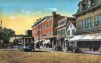
Suffolk Traction Company

Last updated
Suffolk Traction Company
Overview
OwnerPatchogue Electric Light Company
Locale Sayville, Patchogue,
Holtsville, and vicinity.
Service
Type Horsecar, then Streetcar
History
Opened1909
Closed1919
Technical
Track gauge 4 ft 8+12 in (1,435 mm)
Minimum radius (?)
Electrification Batteries

The Suffolk Traction Company is a former streetcar system in Suffolk County, New York. It operated primarily between Patchogue and Holtsville, but also included a route that served Blue Point, Bayport, and Sayville. It was opened in 1909 and ceased operations in 1919.

Contents

Main Line

The four current roads that originally carried the trolley line between Patchogue and Holtsville are South Ocean Avenue, North Ocean Avenue, and what today is Old North Ocean Avenue. The PD Tower at Patchogue Railroad Station served as a control tower for both the Long Island Railroad and the trolleys. Traction Boulevard (also known as Suffolk Traction Boulevard) continued the line, which crossed over the southeast corner of Canaan Lake and headed in a northwesterly direction. North of the Patchogue Highlands area, the paved road became a dirt trail and carried the former ROW towards Holtsville Station. The trolleys that used the road were storage battery cars that ran down the center of the street.

North of Holtsville, Suffolk Traction planned an extension through Farmingville, Selden, Terryville, Echo (now Port Jefferson Station), and eventually Port Jefferson. Unfortunately, the company went bankrupt, even as a bridge was being built over the LIRR Main Line for the Suffolk Traction Main Line on the way to Port Jefferson.

The ROW was abandoned, and much of it was sold to private and public developers later in the 20th century, although the road was still depicted on numerous maps. The dirt trail was visible where it crossed Woodside Avenue and then disappeared entirely at the latter-day site of the town dump where it was obliterated (see below). It picked up again in the woods on the east side of Waverly Avenue just south of Katz's Farm which was located directly south of the LIRR station in Holtsville. The ROW ran along the edge of Katz's Farm so was not discernible.

The Town of Brookhaven installed a landfill on part of the former ROW, leaving a portion of it as an entrance at Blue Point Road. The landfill was transformed into a town park in the early to mid-1970s. During a 2009 repaving project of North Ocean Avenue by the Village of Patchogue Department of Public Works, the former trolley tracks were uncovered and removed for preservation. [1]


Other branches

Besides the main line, Suffolk Traction Company had the Bayport-Blue Point Line between Sayville Railroad Station and Patchogue at Bicycle Path, a section of which is currently NY 112. The line was originally owned by the South Shore Traction Company and ran primarily along Middle Road, Blue Point Avenue, and Montauk Highway. It served the LIRR stations in Sayville, Bayport, Blue Point and Patchogue. A proposed eastbound extension into Bellport and Brookhaven was also on the books, but collapsed along with the Port Jefferson extension of the main line.

A third line called the Sayville Line ran exclusively within Sayville, from the Railroad Station along Sayville's Railroad Avenue, Montauk Highway, and Candee Avenue down to the Great South Bay. This line was originally a horse-drawn trolley, and like the Sayville to Patchogue Line, it was originally owned by the South Shore Traction Company.


Related Research Articles

Montauk Highway is an east–west road extending for 95 miles (153 km) across the southern shore of Long Island in Suffolk County, New York, in the United States. It extends from the Nassau County line in Amityville, where it connects to Merrick Road, to Montauk Point State Park at the very eastern end of Long Island in Montauk. The highway is known by several designations along its routing, primarily New York State Route 27A (NY 27A) from the county line to Oakdale and NY 27 east of Southampton. The portion of Montauk Highway between Oakdale and Southampton is mostly county-maintained as County Route 80 and County Route 85.

<span class="mw-page-title-main">County Route 97 (Suffolk County, New York)</span>

County Route 97 (CR 97) is a major north–south county road in Suffolk County, New York, in the United States. It runs from an intersection with CR 85 in Bayport just west of Blue Point on the south shore of Long Island to a junction with New York State Route 25A (NY 25A) in Stony Brook on the island's north shore. A 5-mile (8.0 km) section of the route from Holbrook to Farmingville is a freeway, while the remainder of the road is an expressway with few at-grade intersections. CR 97 is known as Nicolls Road, named after 17th-century colonial Governor Richard Nicolls.

<span class="mw-page-title-main">County Route 83 (Suffolk County, New York)</span>

County Route 83 (CR 83) is a major north–south county road in Suffolk County, New York, in the United States. It runs from New York State Route 27 exit 52A in North Patchogue to NY 25A in Mount Sinai. The road was to have to run further south along North Ocean Avenue and South Ocean Avenue through the village of Patchogue, but that proposal was canceled. CR 83 is known as North Ocean Avenue south of Granny Road in Medford and as Patchogue–Mount Sinai Road north of that point.

The South Side Railroad of Long Island was a railroad company in the U.S. state of New York. Chartered in 1860 and first opened in 1867 as a competitor to the Long Island Rail Road, it was reorganized in 1874 as the Southern Railroad of Long Island and leased in 1876 to the LIRR. After a reorganization as the Brooklyn and Montauk Railroad in 1879 it was merged in 1889.

<span class="mw-page-title-main">Patchogue station</span>

Patchogue is a station of the Montauk Branch of the Long Island Rail Road in the village of Patchogue, New York. It is on Division Street between West Avenue and South Ocean Avenue. The station is located in the Patchogue-Medford Union Free School District.

<span class="mw-page-title-main">Sayville station</span>

Sayville is a station on the Montauk Branch of the Long Island Rail Road in the village of Sayville, New York, on Depot Street between Greeley Avenue and Railroad Avenue. Ferries to Fire Island board from a port south of the station.

<span class="mw-page-title-main">Sag Harbor Branch</span> Former Long Island Rail Road branch

The Sag Harbor Branch was a branch of the Long Island Rail Road that was the eastern terminal on the south shore line of Long Island from 1869 to 1895 and then was a spur from Bridgehampton to Sag Harbor, New York from 1895 to 1939.

<span class="mw-page-title-main">Harold H. Malkmes Wildlife Education and Ecology Center</span> Park and zoo in Holtsville, New York, US

The Harold H. Malkmes Wildlife Education and Ecology Center is a park, zoo, and ecology site in Holtsville, New York, and operated by the Town of Brookhaven, and located on the site of a former landfill. The official address is 249 Buckley Road, although some of the land owned by the site extends along Blue Point Road and as far south as Woodside Avenue. The ecology center was named for former Town of Brookhaven Superintendent of Highways Harold H. Malkmes (1925-2011), who was still an active member of the Town Government at the time it was opened.

<span class="mw-page-title-main">Holtsville station</span>

Holtsville was a station stop on the Greenport Branch of the Long Island Rail Road. It was located off the southeast corner of the Waverly Avenue grade crossing on the south side of the tracks between Long Island Avenue and Furrows Road in Holtsville, New York.

<span class="mw-page-title-main">Bayport station</span> Railroad station in New York (state)

Bayport was a station stop along the Montauk Branch of the Long Island Rail Road. It was located on Railroad Street between Oakwood and Snedecor Avenues in Bayport, New York, and was the easternmost station along the Montauk Branch in the Town of Islip.

<span class="mw-page-title-main">Blue Point station</span> Railway station in Blue Point, the United States of America

Blue Point was a station stop along the Montauk Branch of the Long Island Rail Road It was located on Martha Avenue on the south side of the tracks in Blue Point, New York, and was the westernmost station along the Montauk Branch in the Town of Brookhaven. Access to the station was through a driveway that emptied onto Blue Point Avenue. The station was originally opened on February 1, 1870, by the South Side Railroad of Long Island and closed on June 1, 1882. The second depot opened around June, 1900, evidently in conjunction with the bridge over Blue Point Avenue. The newer station also had a connection to the South Shore Traction Company trolleys, which were later replaced by Suffolk Traction Company trolleys. Blue Point station closed on September 6, 1980. It was located between Bayport and Patchogue stations, the former of which also closed on the same day. It was located between Bayport and Patchogue stations. The former station site, across from the Blue Point Wine & Liquor store, remains, to this day, gated off, and covered partially in trees, leaves, and weeds.

The Huntington Railroad was established on July 19, 1890 with a trolley line between Huntington Village and Halesite. It was eventually extended to Huntington Railroad Station, then along what is today mostly NY 110 through Melville, Farmingdale, and as far south as the docks of Amityville. Huntington Railroad had only one line throughout its history, although the length varied through the years.

<span class="mw-page-title-main">Northport Traction Company</span>

Northport Traction Company was a trolley service in the Town of Huntington in New York. It ran from 1902 to 1924 and served East Northport and Northport, New York. The company only had one line throughout its history which ran from Northport to Northport Harbor, at what is today Cow Harbor Park. Unlike Huntington Railroad to the west, Northport Traction Company never expanded beyond either Northport or East Northport, and no record exists of any proposal to do so.

The Manhattan and Queens Traction Company, also known as the Manahttan and Queens Transit Company, was a streetcar company operating in Manhattan and Queens County, New York between 1913 and 1937.

References

  1. "Patchogue Village Uncovers Trolley Tracks". Greater Patchogue Historical Society. Archived from the original on June 7, 2009.